


Continued From Agrigentum, Sicilia Part IV
At the very west end of the archaeological park, near the Temple of the Dioscouri, is the entrance to the Giardino della Kolymbethra, a valley located along the north side of the archaeological area. I didn’t visit this on the 2017 trip because I thought having a separate additional entrance was an odd concept. The gardens have a weird opening schedule that is not necessarily tied to the archaeological park, and is not accessible from outside the archaeological park. From November to February it is open daily 10:00 to 16:00, in March through May and October it is open 10:00 to 18:00, in June 10:00 to 19:00, and from July through September from 10:00 to 20:00. Admission is 7 Euros (but can also be purchased in combination with the main entrance ticket). There is a supplemental 15 Euro fee for a guided tour of the hypogeum, part of the 5th century BCE water distribution system. These tours occur a few times a day in July and August and select weekend dates the rest of the year.
I just missed one of the tours for the hypogeum when I arrived, though I’m not sure I would have paid the additional 15 Euros for it anyhow, considering that would mean the entrance and the tour would have cost more than entrance to the archaeological park and museum. Diodorus Siculus describes the Kolymbethra as a large reservoir that was constructed as part of the waterworks built by the architect Phaeax in Agrigentum following the Battle of Himera in 480 BCE. Carthaginian prisoners from the battle were used to build a complex water distribution system through the city. The hypogeum tour is one of these conduits that was part of this system. Whether this valley is the actual Kolymbethra described by Diodorus Siculus is not totally secure, but it seems to be a possibility that generally fits with what is known about it.
Aside from the extra cost hypogeum, there are supposedly other ancient hydraulic elements located in the valley, which is now part of some agricultural/environmental project. There were certainly elements that could have been ancient, but there wasn’t a whole lot of information available on site. A lot of areas were also closed. It was a nice little area that was kind of a welcome break from the largely shade free archaeological area, but the admission was pretty steep for that. The main reason I decided to do the gardens was that they offer the easiest access to the Temple of Vulcan, which is located on a ridge on the north side of the valley. In hindsight, there are probably ways to access the temple from outside the gardens, but the gardens offer a nice path and minimal time on the railway tracks that run alongside the temple.

The identification of the temple as belonging to Vulcan is not based on any archaeological or epigraphic evidence, but rather the interpretation of a literary reference to the temple’s location by Gaius Julius Solinus, writing in the 3rd century CE. The Doric temple was constructed circa 450-425 BCE out of local stone. Today all that remains are a few columns and some parts of the crepidoma and stylobate, but mostly just the foundations. The shape of the temple is pretty well defined by the remains of the foundations, though. There’s a fence around the site, but an opening at the east end. It was somewhat overgrown, though, so there wasn’t much point to wandering around the interior.

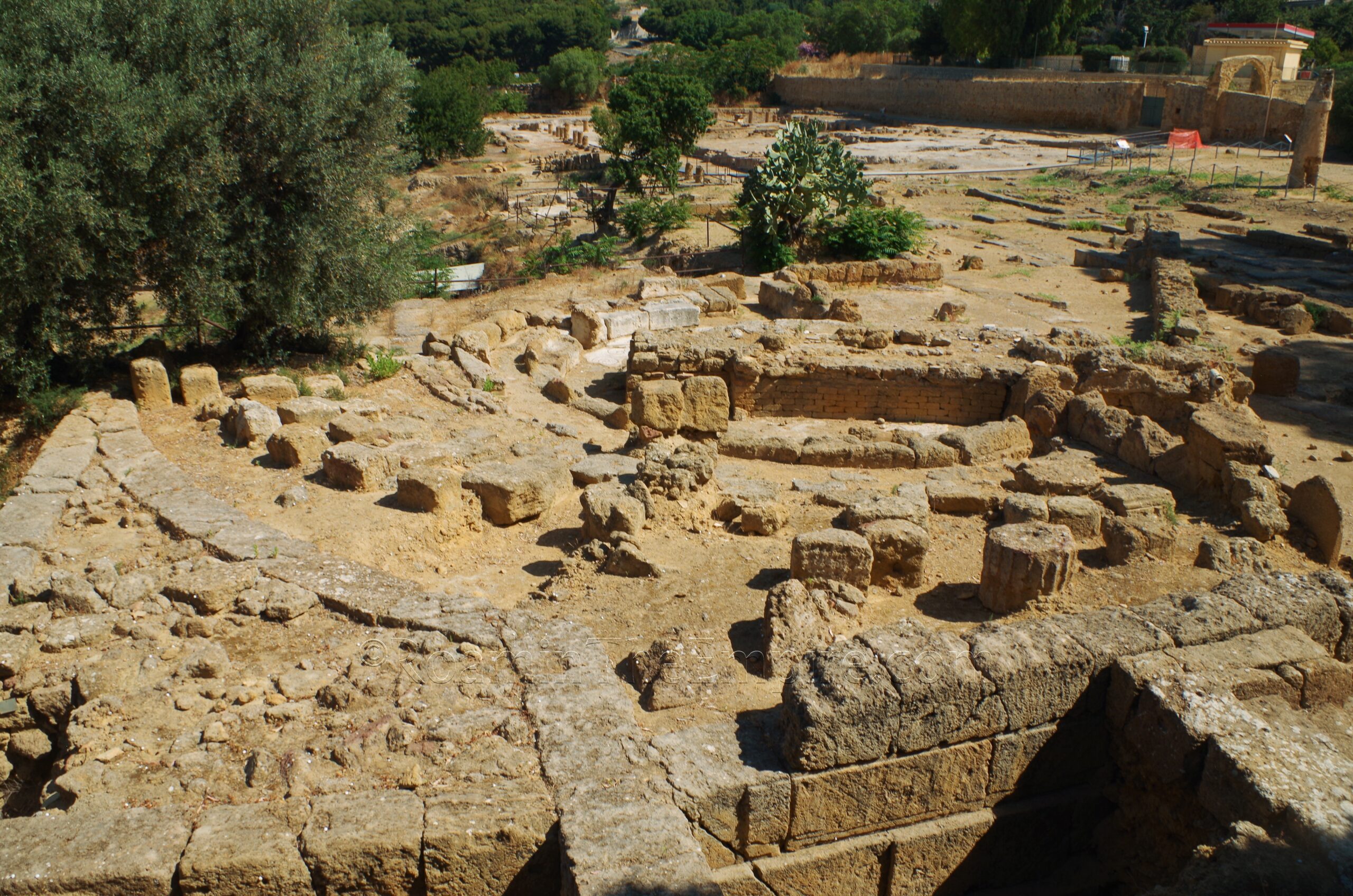
Going back out to the main archaeological site, the western entrance/exit to the site is located at Gate V of Agrigentum. This gate was part of the late 6th century BCE fortification constructions with improvements in the 4th and 3rd centuries BCE. Exiting through Gate V the exterior fortifications are visible on either side of the gate. Off to the left (east) is also the exit of the water channel from the Kolymbethra. Off to the right (west), about 100 meters from the gate along the wall are the remains of an artisan quarter. In particular there are two covered areas and one area that looks fairly recently excavated.

The artisan workshops here began production in the late 6th or early 5th century BCE, around the same time as the fortifications in this area. They seem to have functioned until at least the late 4th century BCE. It is believed that they produced votive terracotta tablets and figures that would be given as offerings at the sanctuaries located inside Gate V. The remains of three kilns have been found here. Under the first (eastern) roofing structure is a fairly intact kiln and also the largest of the three. It was constructed partially carved out of the rocky outcropping. The praefurnium area is located away from the wall with the firing chamber against the wall. The top of the kiln is open and one can see into the firing chamber.

The second kiln is located under the western roof and is more poorly conserved. It is mostly the negative form carved out of the rock with some of the constructed elements scattered around. It was later used as a lime kiln. The third is in the excavated area in front of the eastern roofed area, and is also not well preserved. Cisterns are cut into the rock to the east of the kilns, part of a processing area for the terracotta objects produced in the kiln, but they aren’t very distinguishable. Finally, there’s part of a water channel excavated just before the underpass to leave the archaeological site. Also worth mentioning that in this area, a Roman necropolis is located about 100 meters southeast of the Tomba di Terone. This area is fenced off, with nothing visible from outside. The areas of excavated tombs seem to be largely overgrown as well.

The next point of interest is the ancient agora area of Agrigentum. The agora is located in an excavated area just to the north of the Museo Archeologico Regionale Pietro Griffo. When I visited in 2017, you could look out over the bouleuterion area from the museum, but the area was otherwise closed off, limiting access essentially where the café is. In the intervening years, this has opened up. It is not a ticketed area, but it is on the grounds of the museum, and so it is not accessible when the museum is closed and the exterior gates for the museum grounds are locked. The museum is open year round, daily from 9:00 to 19:00.
The area was developed as the agora in the 6th century BCE. It extended over the whole of the area of the museum, including the ekklesiasterion (discussed in Agrigentum Part I). It remained in use during the Roman period as the forum and underwent a number of interventions over the years of occupation. This northern area of the agora/forum, in particular, received major renovations in the 4th century CE. By the 5th or 6th century CE, it had largely ceased to function and became a dumping ground. As habitation shifted to hill where the modern city is located, the area of the agora remained largely uninhabited until the 13th century CE, when the Monastery of San Nicola, which now houses the museum, was built.
Upon entering the agora area of Agrigentum, immediately toward the west is the complex of the bouleuterion. The building was originally constructed in the 6th century BCE, but took its present form and size by the second half of the 4th century BCE. Most of the remains today of the main structure of the bouleuterion and the adjacent portico and associated buildings to the east date to the Hellenistic period. Capacity was about 300 persons, making it the largest such structure on Sicily. It continued to be used through the Roman period, but perhaps being repurposed as an odeon. The paving stones of the semicircular seating area (which is best visible from the museum overlook rather than the agora archaeological area), as well as some mosaics and other pavements in adjacent areas, dates to the 3rd century CE. The curved marble cornice used in a wall near the entrance of the Chiesa San Nicola (next to the ekklesiasterion in the south part of the museum complex) likely comes from the Roman period of this building.
Continuing in through the gate of the archaeological area, where a raised walkway heads off to the west, the visitor crosses one of the major east-west thoroughfares, plateia E-F. In the Roman period it was the primary east-west street, the decumanus maximus. This is also the road that appears at the very north side of the Hellenistic-Roman Quarter. The walkway then turns down one of the stenopoi/cardines and heads along the east side of the Roman temple.

The simple Roman temple was originally constructed sometime between the middle of the 2nd century BCE and the early 1st century BCE. During the reign of Tiberius, the layout of the area was significantly altered with the addition of a portico surrounding the temple on three sides and a monumental propylon on the south side of the complex. Part of this portico has been reconstructed on the north side of the temple with some of the statues found there on display. Another major change was the placement of a templum rostratum in front of the cella of the temple (south side), and replacing the typical frontal staircase with two small rear-facing staircases along the side of the rostratum. One of these is visible on the west side of the temple. A second stenopos runs along the eastern side of the temple complex.

The final stop for Agrigentum is not that far from everything, but is a little out of the way due to the presence of the run up to the Viadotto Akragas I. On the west side of the viaduct, right near the start is the Pezzino Necropolis. This necropolis had several periods of use between the 6th century BCE and 3rd century BCE. It is believed that this may have been the necropolis that is mentioned by Diodorus Siculus as having its funerary monuments destroyed by the Carthaginian besiegers in 406 BCE in order to gather materials for the siege. Rock hewn tombs are visible on either side of the small dirt road that leads to the necropolis, these in particular dating to the 4th century BCE. Even in antiquity, this necropolis was bisected by an ancient road. The graves are not directly accessible, as the areas are fenced, but they are fairly visible from the road, even though they are a little grown over with vegetation.
There are two other areas where this necropolis is visible, just to the north among the tangle of onramps to the viaduct, as well as a small patch on the opposite side of the viaduct from the main area of the necropolis and about 65 meters north. Neither of these areas are really accessible because there’s no place to stop on these roads and no real pedestrian access. It’s also worth noting that Gates VI and VII of Agrigentum are identified and visible, but I was not able to find good access to them. I have pinned them on the map, though.


Sources:
Barresi, P., M. Liuzzo, and M. Scialfa. “Per una lettura socio economica dei contesti abitativi: la casa I E/F nell’insula I del Quartiere ellenistico-romano di Agrigento.” Agrigento: Archeology of an Ancient City. Urban Form, Sacred and Civil Spaces, Productions, Territory, Giuseppe Lepore and Luigi Maria Caliò (eds.), Heidelberg: Propylaeum, 2021.
Merola, Marco. “Sicily’s Lost Theater.” Archaeology, March/April 2019.
Niccoli, Chiara and Mauro Serio. The Valley of the Temples of Agrigento and Heraclea Minoa, Milan: Skira, 2018.
Pecoraro, Anna Rita. “La casa II D del quartiere ellenistico-romano di Agrigento.” Paesaggi Urbani Tardoantichi: Casi a Confronto, Maria Concetta Parello and Maria Serena Risso (eds.), Bari: Edipuglia, 2016.
Polybius. Historia, 9.27.