


Most Recent Visit: May 2021
About 10 kilometers to the east of Corinth is the city’s Saronic Gulf port, Cenchreae (Kenchreia). According to the 2nd century CE writer Pausanias, the two ports of Corinth, Chenchreae, and its counterpart on the Gulf of Corinth, Lechaion, were named after the sons of the nymph Peirene with Poseidon; Leches and Cenchrias. It is Cenchreae’s namesake, Cenchrias, who is accidentally killed by Artemis and causes Peirene to become a flowing spring of tears and becomes the mythological foundation for the Fountain of Peirene in Corinth.
The actual foundation of Cenchreae is unclear. It certainly existed in the Classical and Hellenistic periods and is attested by writers such as Thucydides, but does not seem to have been much more extensive than a fortified military port. If there was a settlement associated with the pre-Roman port, it appears to have been located a bit farther inland. It doesn’t seem to have been until the Roman re-foundation of Corinth that a settlement really grew up in the area of the actual port. Significant improvements were made to the harbor works during the Augustan period.
Around the time that the Isthmian Games were returned to nearby Isthmia in the middle of the 1st century CE, Cenchreae saw a significant period of growth. Most notably, evidence of civilian occupation around the harbor becomes apparent. By the Hadrianic period, it seems to have been a heavily populated area. Cenchreae features as the setting for the climax of Apuleius’ Metamorphoses. In the novel, Cenchreae is portrayed as a diverse settlement with, notably, an active and thriving cult devoted to Isis, which fuels the final scenes. Pausanias too notes the presence of the Isis cult here, as well as a significant temple dedicated to Aphrodite. The settlement here seems to have largely been abandoned by the 7th century CE, before being reoccupied later.
Getting There: The modern town of Kechries is only about 15 minutes by car from either modern Corinth or ancient Corinth. Unfortunately, while there is apparently a pretty good local bus system in place for the region around Corinth, the online routing and scheduling information is rather poor and makes it difficult to plan such things ahead of time. A personal vehicle is probably best for traveling around the area, including to Kechries. Once there, the few remaining features are pretty close to each other; one can easily park in one place and then walk around to the remains.
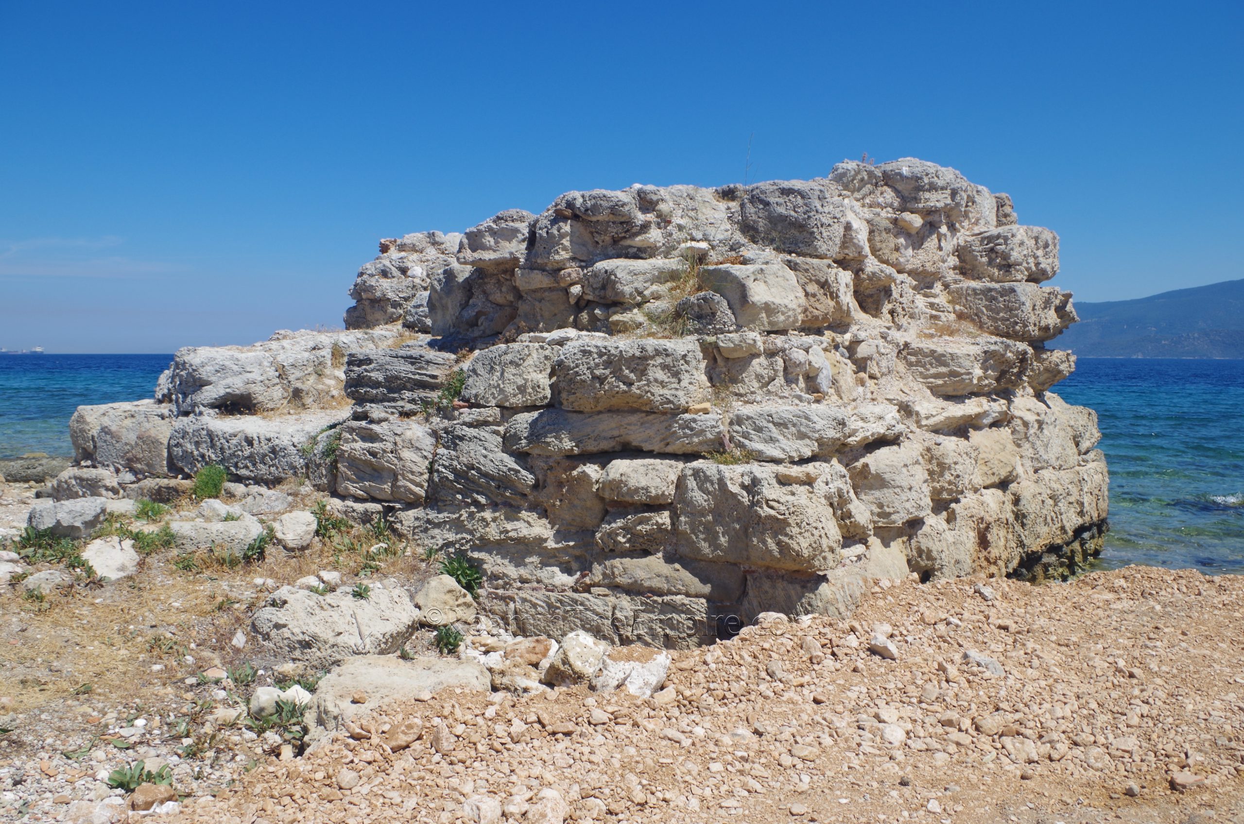
There isn’t a whole lot that remains of Cenchreae but what is here is fairly interesting. The first set of remains is located on what would have been the southern mole of the crescent shaped harbor that was constructed during the early years of the Roman colony at Corinth. There isn’t really an address, but there is a moderately popular beach and small parking lot located adjacent. Because of the size of the parking lot, I actually opted to park at a much larger open area a little bit to the south (about 115 meters), and has access to the area via a short walk along the beach. I’ve pinned both on the map.
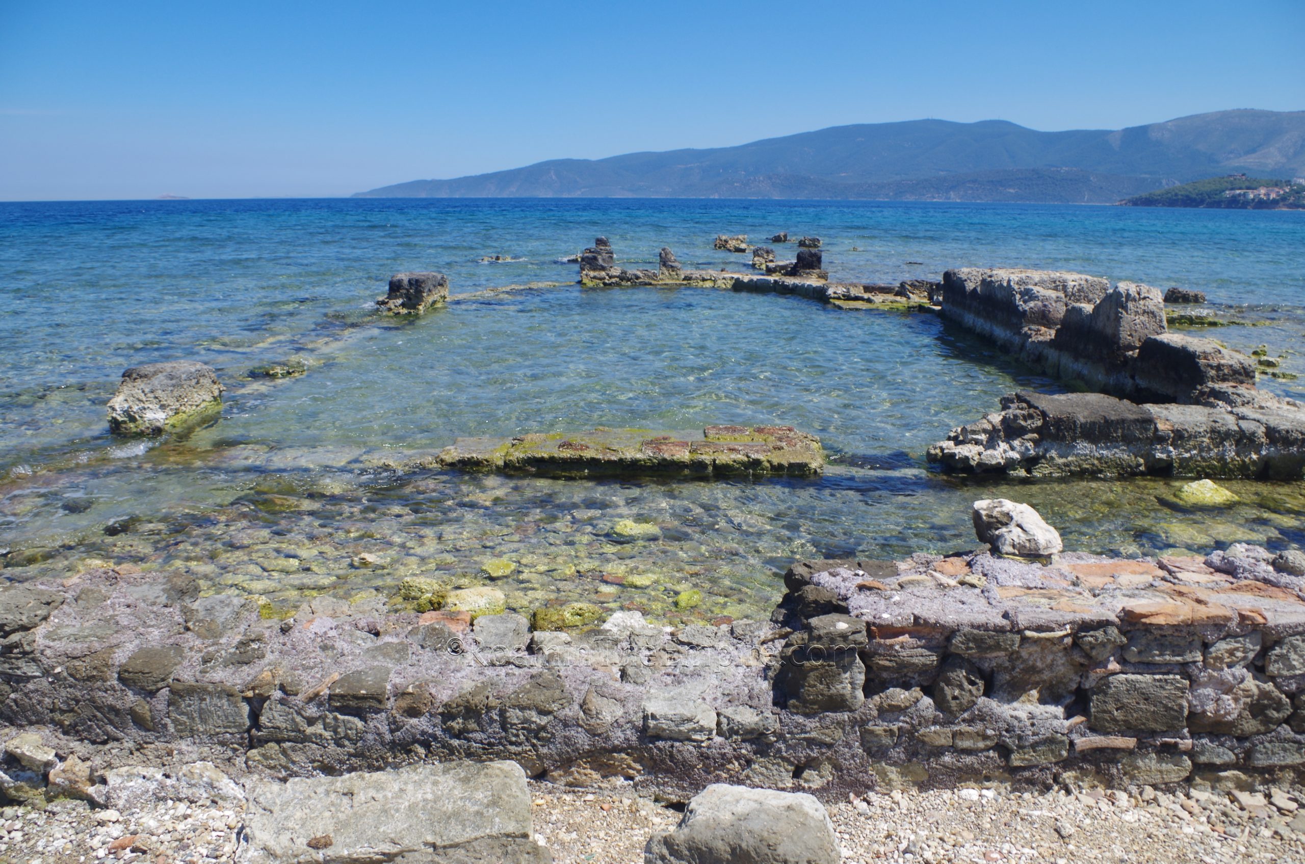
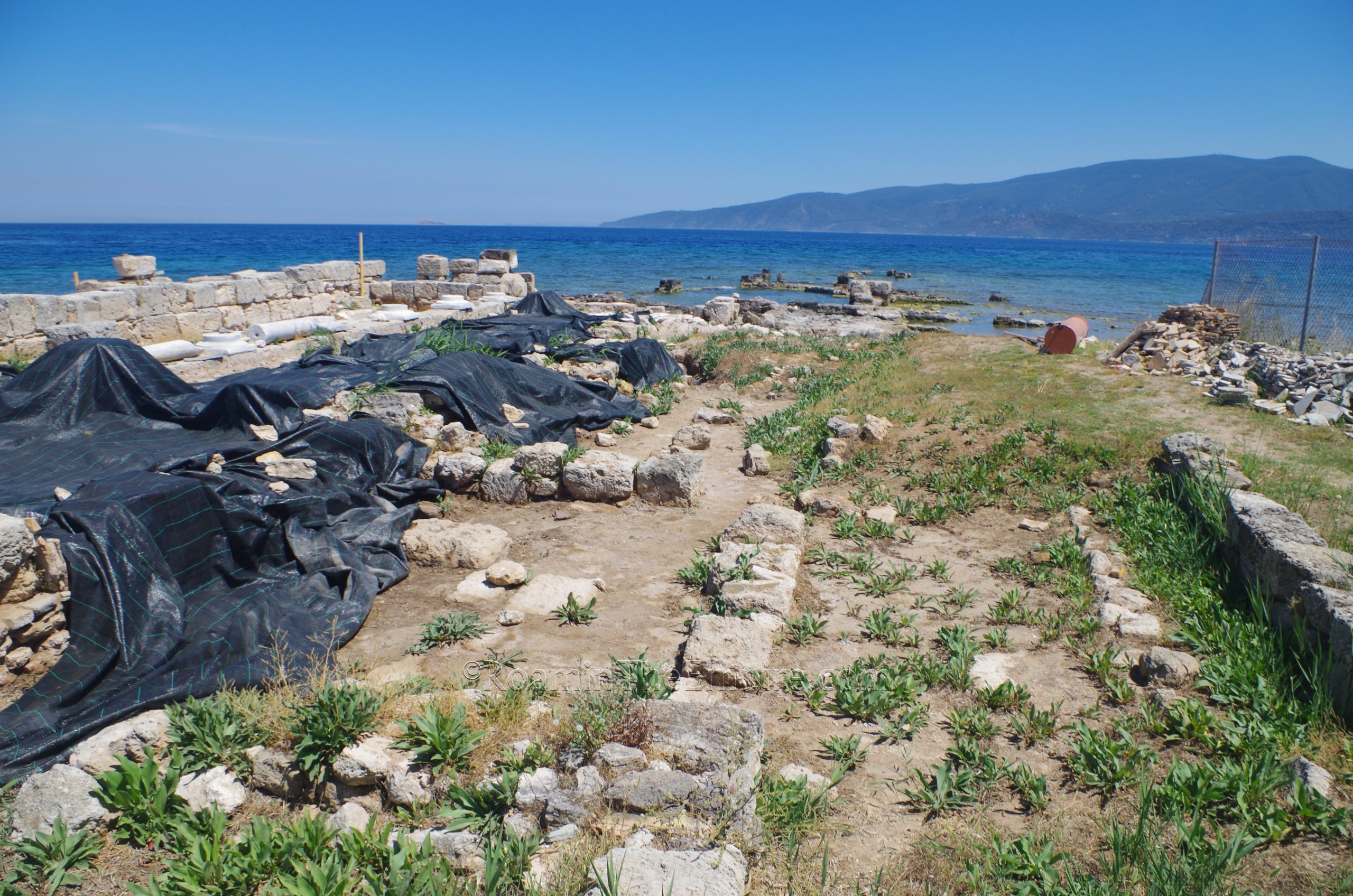
The site itself is technically fenced, but it’s really only fenced on the landward side. The fences do not extend all the way to the water, though. In fact, they basically stop at the beach, and do not fence the site off from the beach, so essentially there is free access. If you approach from the north along the beach, there is a sign that says that access to the site is restricted, though it was obviously not enforced in any meaningful way. From the south, however, there is no such posted warning. There did look to be some recent or ongoing excavations, so care should be taken not to disturb the projects and as always, not to abuse the privilege of visiting unsupervised sites. While some of the site is completely on land, the structures gradually drop off into the water, the result of tectonic activity that has dropped parts of the shoreline up to two meters.
The interpretation of the remains at this location are varied. Completely on the shore, closest to the road is what has been described as being a lighthouse dated to the later Roman period. This is where some of the more recent excavations seemed to be taking place, so perhaps in the near future, there will be some further or better understanding of the exact nature. A bit farther toward the shore is a robust construction that juts a little bit into the water, but is preserved at a higher level than much of what remains around it. This is identified as being a 4th century CE Christian basilica.
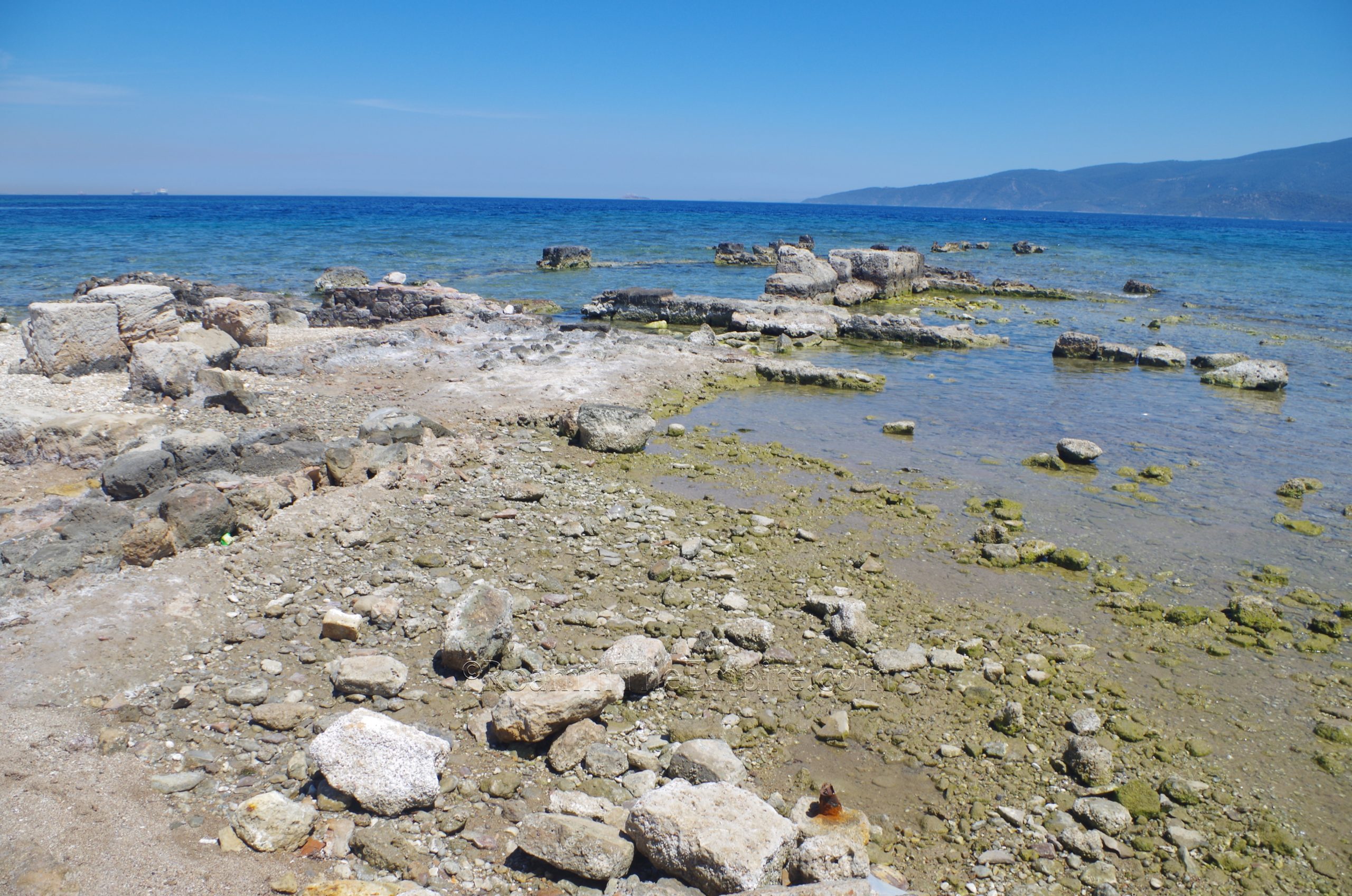
Beyond the basilica, the remains start sinking into the water, many of which seem to be storehouses of some type. One more very identifiable construction can be seen, though, a partially submerged (but still very visible above the water line) apsidal structure. During the original excavations in the 1960’s, this was identified as the Temple of Isis; perhaps the very temple that is mentioned in Apuleius. Pausanias too mentions the presence of a temple to Isis near the harbor of Cenchreae. Subsequent interpretations, however, seemed to dismiss this idea, with some other suppositions being a nymphaeum or perhaps a triclinium or meeting hall for important business meetings. Maybe even just one element of a much larger elite complex. Within this structure, most notably, over 100 glass opus sectile panels were found stored in wooden crates, left there and submerged following an earthquake around 375 CE. The glass panels are now in the nearby Isthmia Archaeological Museum.
The panels seem to have been shipped from Alexandria, and the interpretation of some of these panels as depicting Nilotic scenes have been cited as evidence that the space could have been related to the Isis cult. Others have called the connection into question. One bit of evidence that does heavily favor the Isis theory, though, is the discovery in the immediate area of an inscribed column with the Greek word Ὀργία; literally referring to secret rights or mysteries. This word is interpreted as being an epithet of Isis and was also used by Plutarch to specifically describe the mysteries of Isis and Osiris. Like the panels, the column is now at the Isthmia Archaeological Museum. Beyond the apsidal structure, only bits and pieces of walls jut above the surface of the water, and it’s difficult to see much of anything in the water due to the angle, though satellite map views show there to be some significant remains in the water beyond this.
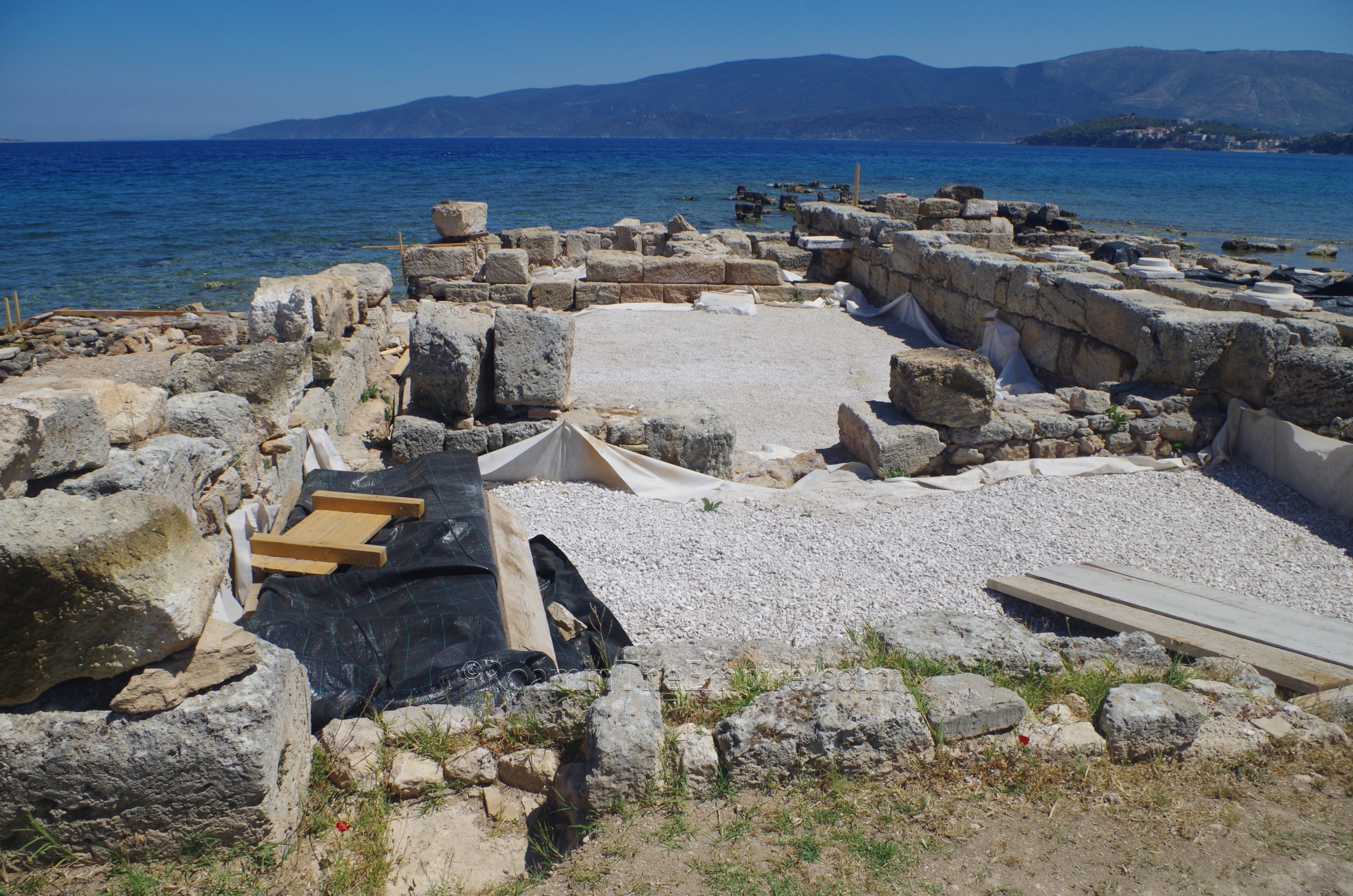
A short walk along the beach northward (or drive; there were some people driving on the road right above the beach) leads to what would have been the northern mole of the harbor. Nothing is really left on the actual mole, as there is in the south. What looks to be a tower is located on the edge of the land before extending out into the area of the north mole, of which the area is clearly visible on satellite maps. Stretching inward from here is a large complex about 65 meters in length. The remains here are fenced, though the fences have numerous holes in them and are obviously not maintained, so, again, care should be exercised not to disturb things, but there doesn’t seem to be any ongoing effort to actually limit access to the site.
This structure has long been identified as the Temple of Aphrodite, though this identification seems to derive mainly from Pausanias’ description of Cenchreae; he noted that the Isis temple and Aphrodite temple were essentially opposite of each other. So if Isis temple is on the south mole, then the Aphrodite temple should theoretically be somewhere on or near the north mole. There does not seem to be any other indication to identify the space as being a temple to Aphrodite or, indeed, having any sort of religious function at all. The building is more likely a wealthy residence. Various building phases between the 1st and 4th centuries CE have been identified.
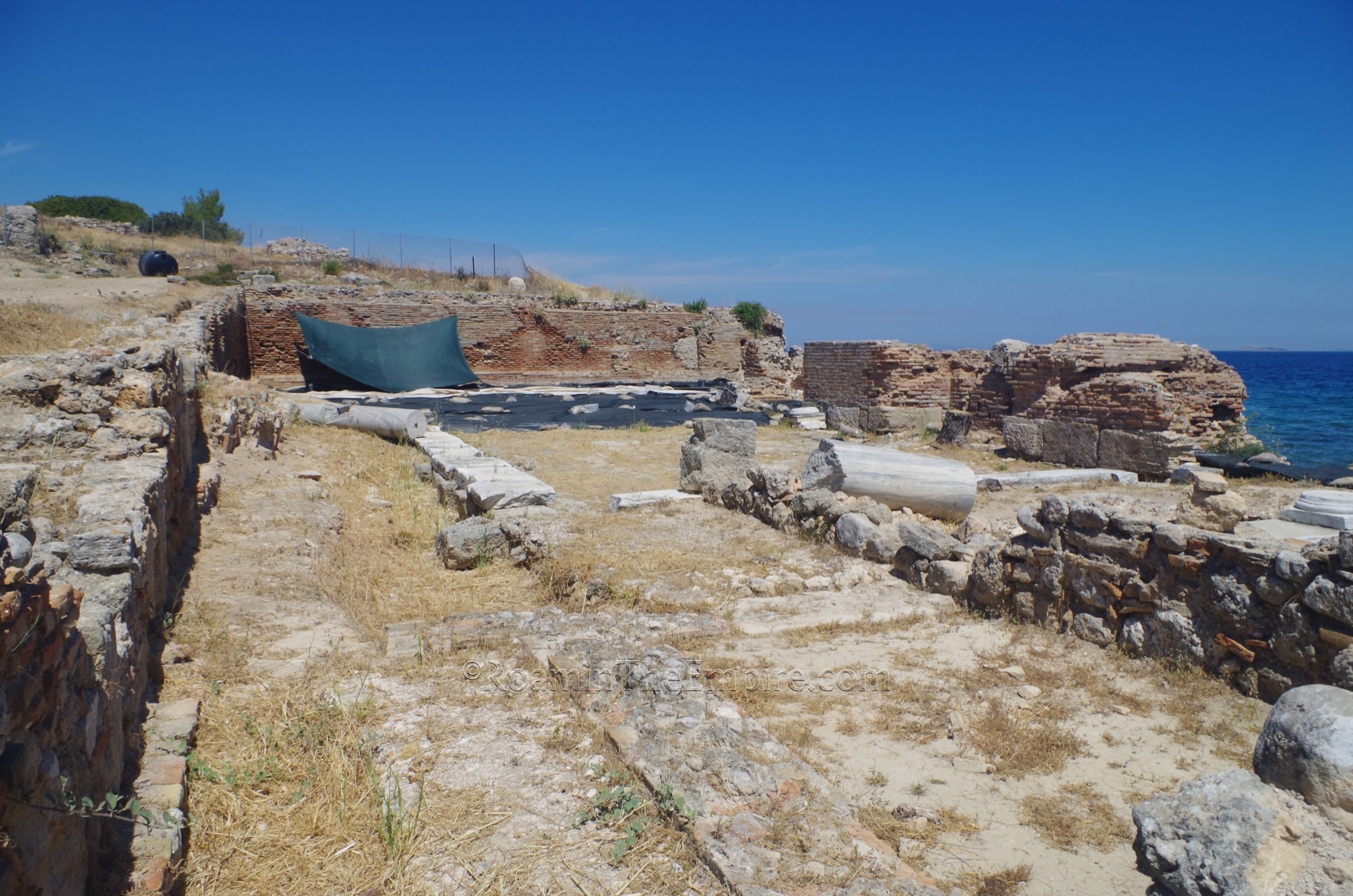
Walking around this area, I noticed there were some remnants of intact marble revetment on the seaward side of the structure. At the far (north) end of the open area that makes up the bulk of the remains here are some intact mosaic pavements. Most of this was covered up when I visited, but there were some areas that were not covered and were visible, revealing some parts of two different patterns of geometric mosaic that made up the flooring of this area of the residence. This room ends with an intact brick wall preserved up to a significant height (a few meters) where the building abuts the hill that rises up from the shore. A bit farther to the north, on that hill, are some Roman era pit graves. But, as was the case that I encountered with a number of sites in the area at that point in the summer, there was really too much overgrowth to get close or see anything.
Cenchreae can honestly be done in probably about an hour, an hour and a half. It’s not very big and the two areas are fairly close together.


 of the southern mole.")


Sources:
Apuleius. Metamorphoses, 10-11.
Moyer, Ian. “Why Cenchreae? The Social Topography of a Desultory Crossing in Apuleius’ Golden Ass.” Phoenix, Vol.70 No. 1/2, Spring-Summer 2018, pp. 129-146.
Pausanias. Hellados Periegesis, 2.2-3.
Rife, Joseph L. “Religion and Society at Roman Kenchreai.” Corinth in Context: Comparative Studies on Religion and Society. Leiden: Brill Publishers, 2010.
Thucydides. Historiai, 4.42.