


Continued From Diocletianopolis, Thracia – Part I
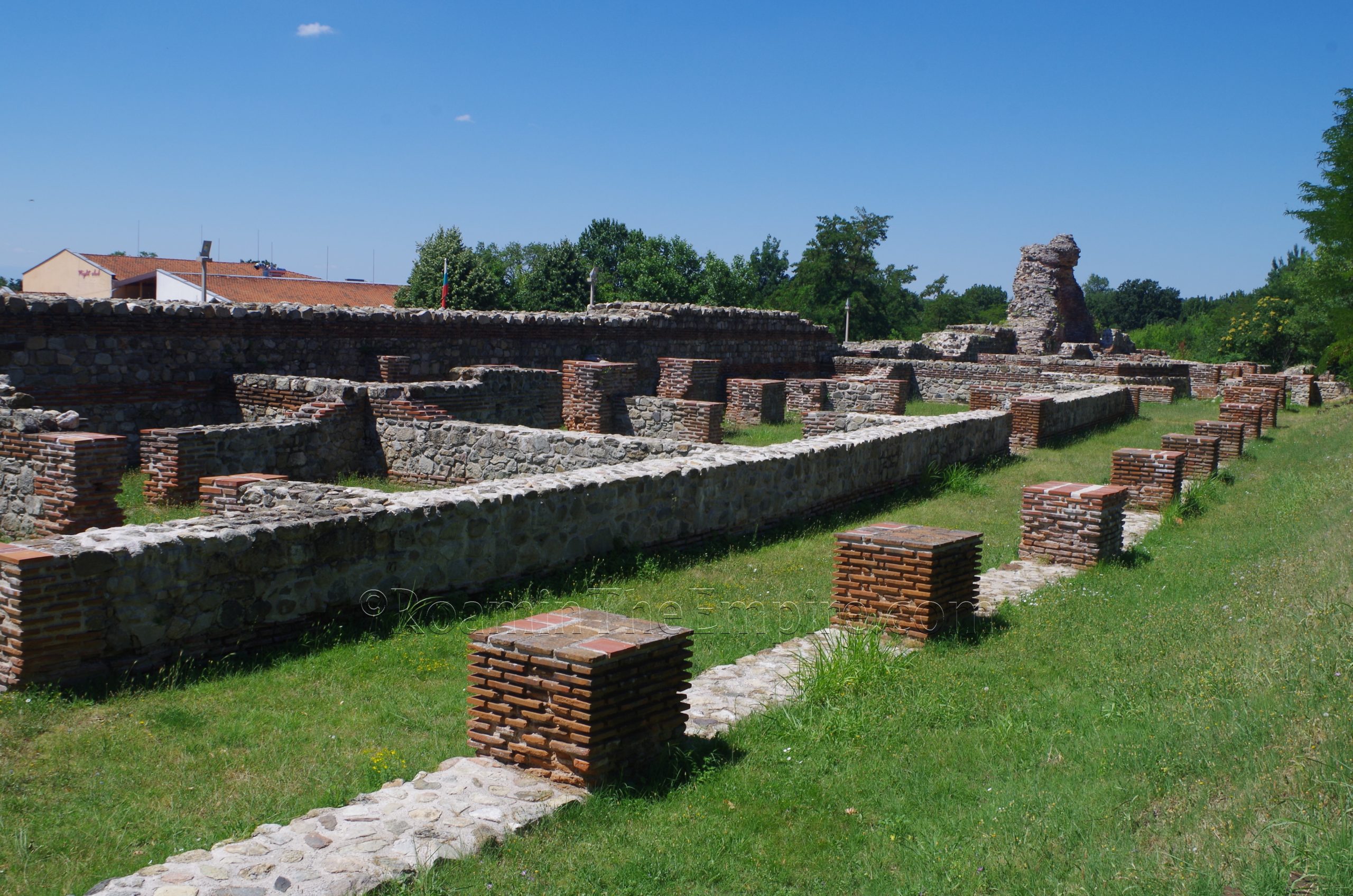
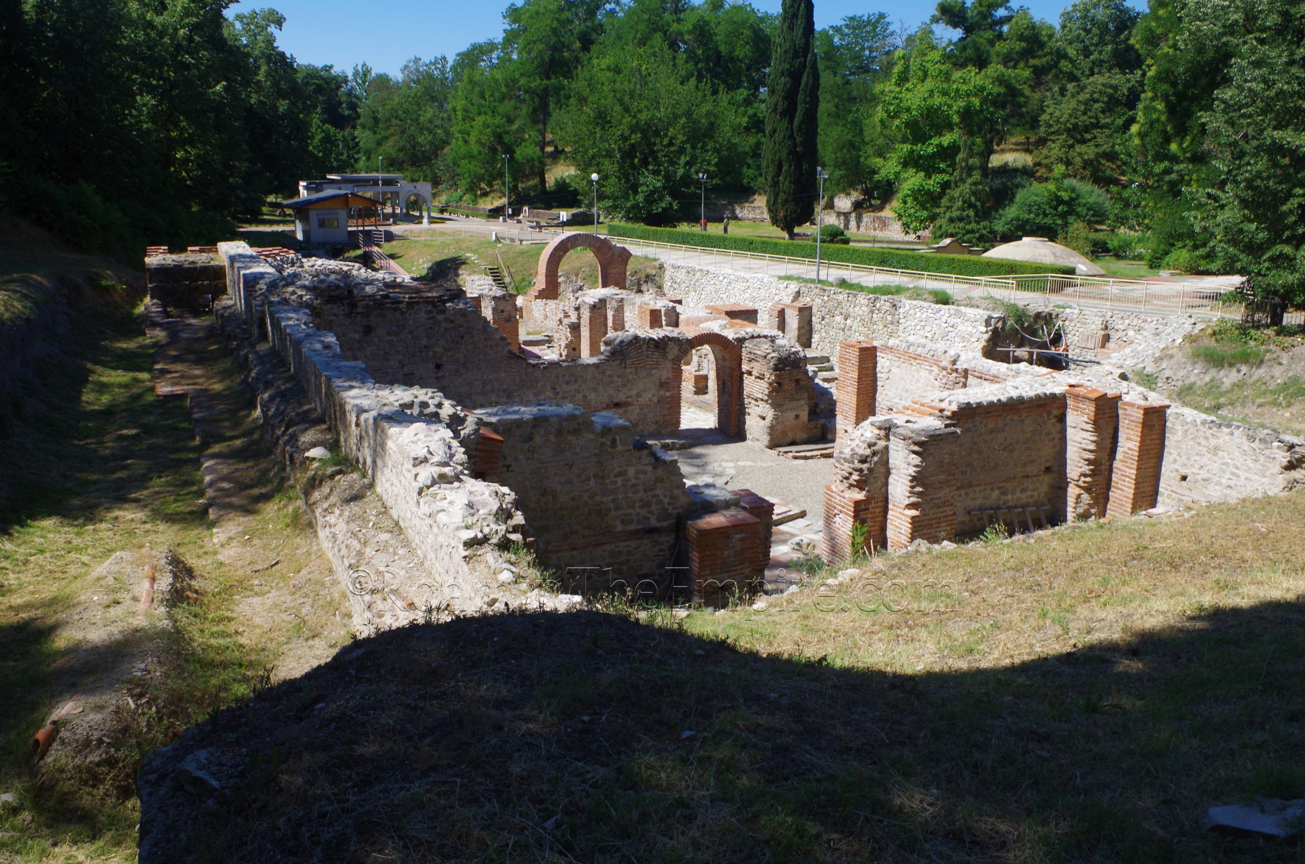
Continuing on at the Camel Gate, inside the Camel Gate, located just to the west, are the remains of barracks abutting the fortification wall. These barracks were constructed in the late 4th or early 5th century CE. Originally the barracks built at this time along nearly the entirety of the southern wall and up along the southern part of the eastern wall. The barracks are estimated to have housed about 600 soldiers, part of a contingent stationed at Diocletianopolis in response to the increasing pressure of invasion and migration following the Gothic and Hun migrations and invasions that had been intermittently threatening area since the 3rd century CE. The barracks here consist of a series of rooms against the wall, with what would appear to be a portico lining the northern side.
The first 65 meters or so west of the Camel Gate is made up of barracks, but farther west there is a bit of a gap and then a separate structure. This also would have originally been part of the barracks. In the middle of the 5th century CE, it appears that a Christian basilica (Basilica No. 1) was constructed in the place of this area of the barracks. The basilica takes up about 26 meters of the barracks space with an apse on the east end of the structure. This is apparently the only double-nave basilica that has been found in the territory of Bulgaria. At the west end of the basilica are about another 35 meters of the barracks, which are of the same form of the barracks on the east side of the basilica. Just beyond the end of what is visible here, would have been the depression where the westernmost of the southern gates of Diocletianopolis was located.

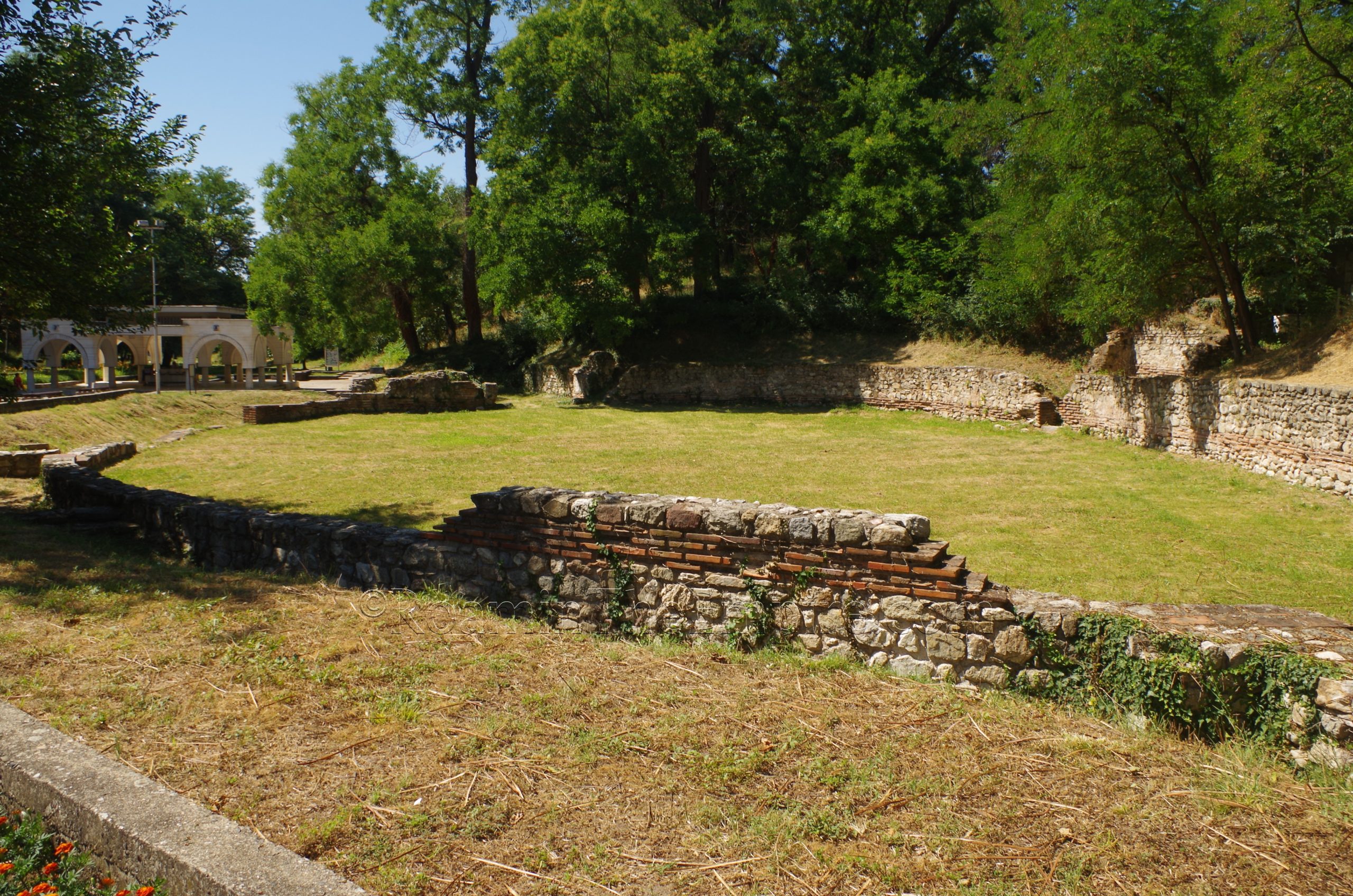
Doubling back to the east end of the barracks near the Camel Gate, there is a path that leads off in a northwestern direction. About 75 meters on along this path is a large complex that is described as being a late Roman residential building. There are essentially two separate domestic structures here that were originally constructed in the last half of the 4th century CE. The first is a roughly 58 x 42 meter residential building centered around a large peristyle courtyard. The bases for the pillars can be seen around the edges of this open space while the living spaces surrounded this, which would have housed a number of separate residences. The entrance was at the east side of the building, which opened up onto a cardo. This entrance is flanked by tabernae. On the north side of this building was a similar, but smaller, residential building also centered around a peristyle courtyard. Both buildings were likely comprised of at least two levels. They seem to have been destroyed during attacks on Diocletianopolis by the Huns in the middle of the 5th century CE, but were then rebuilt.

Back to the Camel Gate, there are also some remains of the barracks on the east side of the gate stretching for about 70 meters. The construction of the modern road that runs on the inside of the walls, however, seems to have led to much of it being destroyed. So there is really only about maybe 7.5 meters of the barracks remaining between the road and the wall.
Back outside the walls of Diocletianopolis, about 100 meters south/southeast from the Camel Gate along Ivan Vazov Boulevard, on the west side of the road, is another Christian basilica. This one is designated as Basilica No. 3. The basilica was built in the latter half of the 4th century BCE and dedicated to St. Stefan, according to a Greek inscription found there and now housed in the archaeological museum. In the mid-5th century CE, the basilica was destroyed by the Huns and it was subsequently rebuilt in the 6th century CE. The basilica is fenced and has a gate, but there are no hours posted, so it is unclear if the gate is ever locked and the basilica inaccessible. Otherwise there is no ticketed entrance.
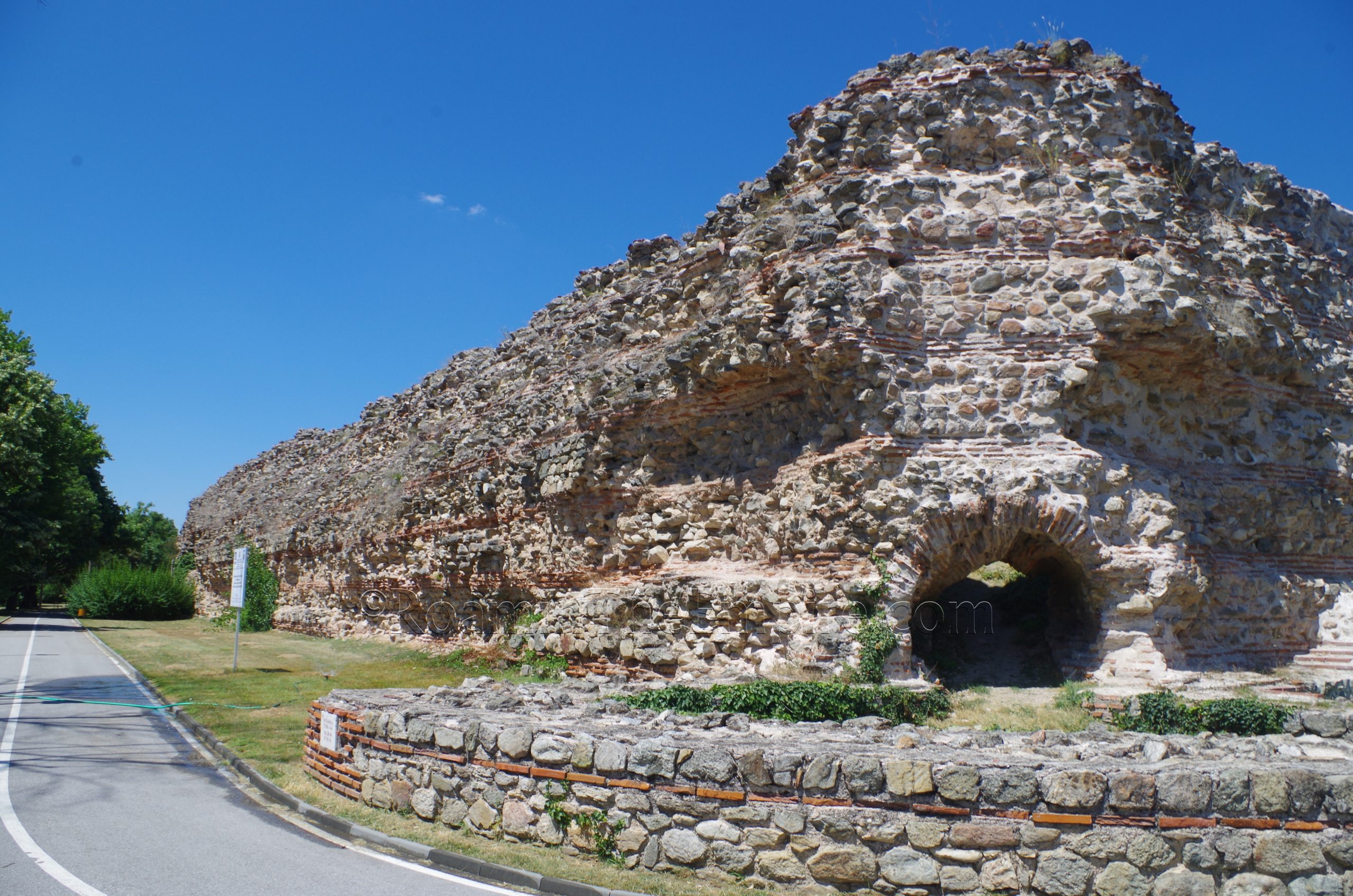
Once again back to Camel Gate, there is a road running inside the walls and a walking path outside the walls. Either way there isn’t much difference other than seeing the towers at the exterior. The walls are preserved at a bit greater height just to the east of the Camel Gate, but at a significantly greater height approaching the southeast corner. There are a few big holes in the walls, though. Right past the corner, as the walls turn back toward the north, about 30 meters in the walls are once again preserved to a relatively low height.
About 125 meters from the southeast corner of the fortifications, some remains can once again be seen just inside the circuit of the walls. These seem to have the same structure as the barracks near the Camel Gate, and although they are not labeled as such, are probably another section of barracks. About 60 meters beyond the barracks is the eastern gate of the city. The eastern gate was repaired after collapsing as part of the late 4th century works on the walls and gates. It was destroyed again in the Hun invasion of the mid-5th century CE, but was immediately repaired. Not much remains of the actual main portal of the gate, aside from a couple meters of the bottom of it. A better state of preservation than the north gate or southwest gate, but not quite as good as the Camel Gate or western gate. One of the pedestrian portals to the south has been reconstructed somewhat, and adjacent to that are the remains of a staircase up the walls.

Continuing along the walls toward the north, there are some sections that are preserved several meters high, and others at less than a meter. Upon reaching the northeast corner of the fortifications, there is another extramural basilica, Basilica No. 8. About a 7 minute walk away, it is located 250 meters east down Hristo Botev Boulevard to General Gurko Boulevard (бул. Генерал Гурко) and then turn south on that street for about 185 meters to arrive at the basilica. This three-aisled basilica with a semi-circular apse was constructed in the 5th century CE. It is open access in a public area, and can be visited at any time.
Back to the northeast corner of the walls, the northern circuit can then be followed about 200 meters back along Hristo Botev Boulevard to our starting point at the north gate. The walls near the northeast corner are actually at an elevated level comparative to the street, but eventually meet the street level. The walls are generally preserved to a relatively low height, as they were in the northwest, but there are a few instance of preservation to a greater height.

From the north gate it’s about a 450 meter walk to the Hisarya Archaeological Museum, located at 8 Alexander Stamboliyski Street (ул. Александър Стамболийски 8).The museum is open daily from 8:00 to 12:30 and 13:30 to 16:30. Admission is 3 Lev, but once again, a 7 Lev combination ticket can be bought which includes the tomb and the baths.
The archaeological museum is relatively small. There are some interesting pieces found locally in excavations of Diocletianopolis. Appropriately the head from a statue or bust of Diocletian. A number of votive reliefs, several of which are dedicated to the nymphs; again appropriately given the presence of the thermal springs here. There are a couple of interesting inscriptions, including the previously mentioned inscription from Basilica No. 3. Otherwise there are a lot of smaller finds; a few bronze pieces and coins as well other miscellaneous objects and terracotta/ceramics. A few of the objects and informational signs have English translations, but not all of them. Much of the information is, not surprisingly, in Bulgarian. Given how off the typical tourist path this stop was, I was pleasantly surprised that there was any English at all. All told, I probably spent about 25 minutes in the museum. A gem and mineral museum in the same complex is included in the admission here.
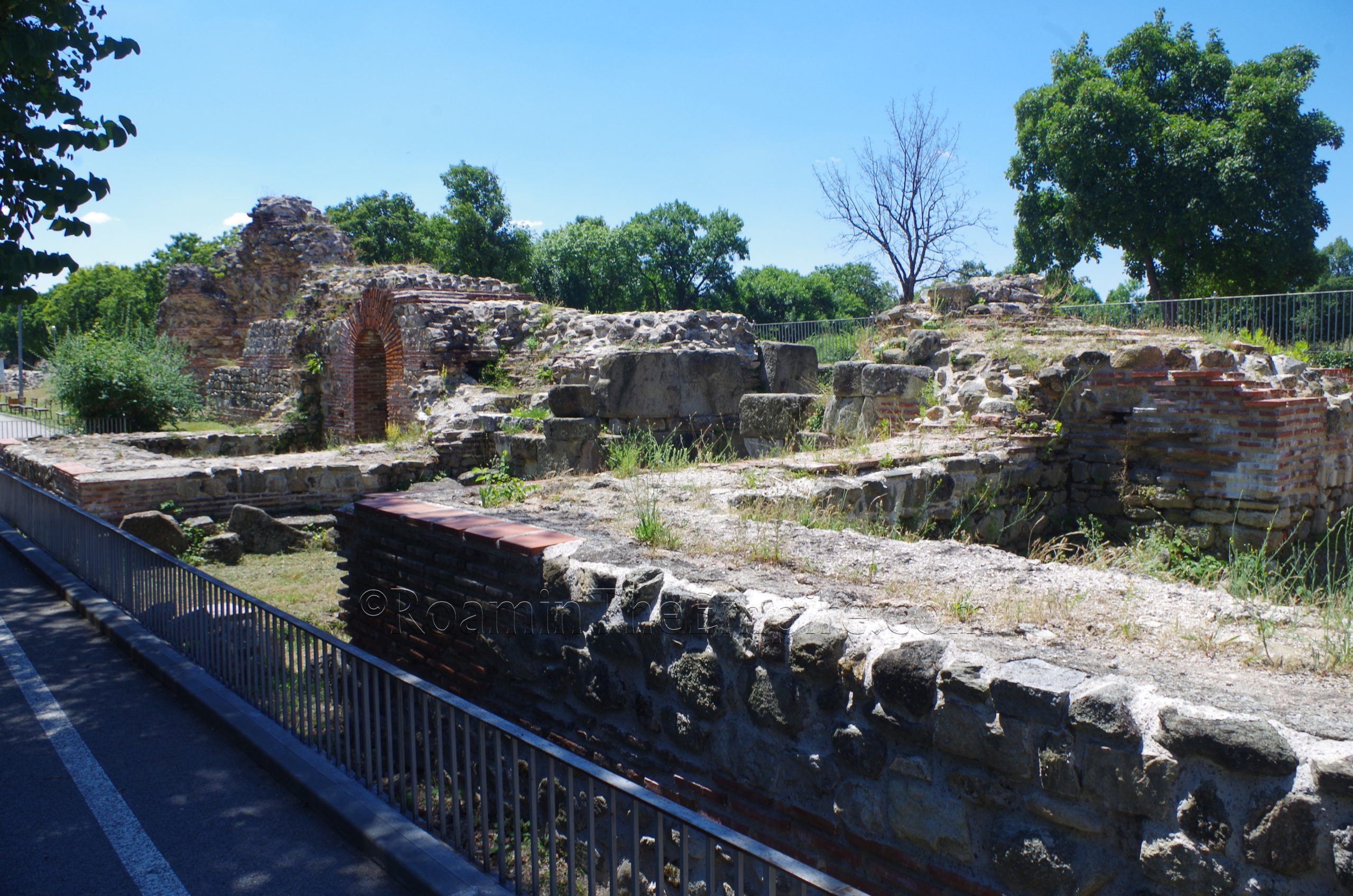
A five minute walk to the southwest via the street just to the south of the museum, and with signs indicating the direction of the Roman Thermae, is the final grouping of vestiges of ancient Diocletianopolis. A walkway off Ivan Vazov Boulevard, directly across from the street that leads here south of the museum, is the Momina Sulza park. Leading into the park about 100 meters is a path, and at the end of this path as it turns toward the south are the remains of a late Roman public building, as it is described. Built in the early 4th century CE, this structure has two levels preserved, though the exact nature of the building seems unclear. The lower level comprised of 5 rooms has some features to suggest the area was vaulted. In the summer, this area is waterlogged and isn’t really accessible, but is visible from a distance. Atop the area behind this lower level are the remains of some wall foundations from the upper level.
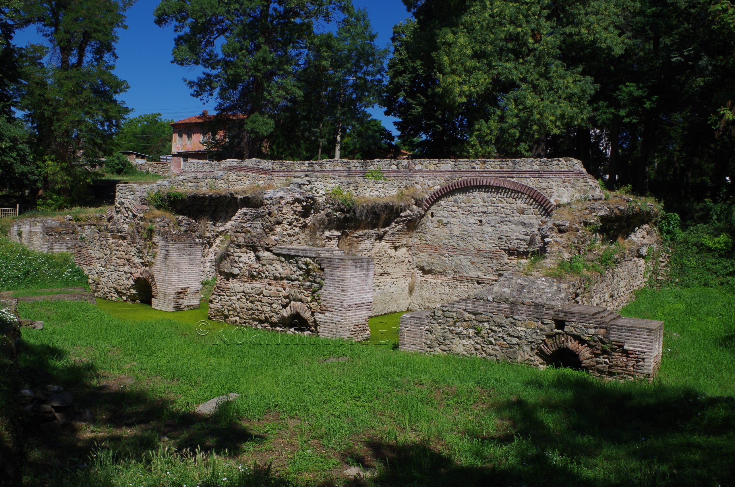
To the south of the public building are the Roman Termi, the baths. The baths are a ticketed site. These are open daily between 9:30 and 13:00 and from 14:00 to 18:00. Admission is 3 Lev, but they are again part of the combination ticket with the tomb and the archaeological museum that costs 7 Lev.
The baths have been for both my visits, and still seem to be at the moment, in a state of ongoing repair and restoration. They are apparently intermittently closed at times as part of these interventions. Work began on the baths, which are located near one of the thermal mineral springs (still publicly accessible and in use today as a water source about 75 meters to the southwest), in the middle of the 2nd century CE, shortly after the area of Diocletianopolis (then Augusta) was declared imperial domain by Hadrian. At first a single caldarium (caldarium 1) with a large central pool and the apodyterium were constructed. The building also functioned as a sanctuary for the Nymphs. A second caldarium (caldarium 2) with a series of smaller pools and the tepidarium were built just to the east in the late 2nd or early 3rd century CE. Additional areas in the north seem to have been built in the 4th century CE. Excavations are ongoing in these parts, with some areas only recently being uncovered and visible, including another room with a large double pool that was had not been identified and was partially unexcavated. Another room with a pool that is now visible was completely unexcavated in 2019. The area to the south of the original apodyterium also seems to be a 4th century CE extension.
Most of the areas that were actually excavated were accessible when I visited. Or at least the rooms could be looked into, if not completely visited. Such as caldarium 1, which has also since been further uncovered, it seems. The pool of caldarium 1 and the two smaller side pools of caldarium 2 are filled with water, with caldarium 1 appearing to be fed from the mineral springs. There’s a helpful sign with a diagram of the baths and explanations in both Bulgarian and English on site.
The final site is located just to the southwest of the baths; the amphitheater of Diocletianopolis. Built in the late 3rd or early 4th century CE on a natural slope, it had a relatively short lifespan and was believed to have been destroyed in a Gothic attack on the city around 376-378 CE. The interior arena space of the amphitheater is somewhat oval in shape, but is not quite precisely so. Rather it has a lot of imperfections to its form. Mostly what is visible are the remains of the podium wall and some foundations of the supports of the cavea. There is no information on site, but there was an information card (with English) in the archaeological museum.
Hisarya and the remains of Diocletianopolis make for a pretty good day trip from Plovdiv. It took me about 3 and a half hours to walk around and see everything. With the travel time to and from Plovdiv, though, it takes the better part of a day for the whole trip by public transportation. Perhaps half a day if one is using a private vehicle. The city is very walkable and nothing is very crowded, even at the height of summer. It’s certainly a bit off the typical tourist circuit, but definitely worth a stop if given the opportunity.


.")


.")


Sources:
Ivanov, Alexander. Spectacle Buildings in Late Antiquity from Bulgaria. Bulgarian Academy of Sciences, November 23, 2022.
Manev, Alexander. The Fortification System of Diocletianopolis During Late Antiquity. Bulgarian Academy of Sciences, November 24, 2022.
Smith, William. Dictionary of Greek and Roman Geography. Walton & Murray, 1870.