


Most Recent Visit: July 2019
Among the modern town of Hisarya, Bulgaria are the remains of what was once the Roman settlement of Diocletianopolis. Habitation at the site of Diocletianopolis seems to date back at least 6,000 years. The prevalent mineral hot springs there likely attracted attention to this particular location. By the 5th century BCE, a Thracian town occupied the site, though its name is unknown. The city also would have fallen under the hegemony of the Odrysian Kingdom in the 5th century BCE. Archaeological finds indicate robust trade with the Greek settlements of the Northern Aegean. At this time. The Odrysian Kingdom was subjugated by the Macedonians in the 4th century BCE, but seems to have regained some nominal independence as a series of entities following a number of conflicts around the middle of the 3rd century BCE.
Around 20 BCE, the Odrysian Kingdom, and with it the settlement that would become Diocletianopolis, became a client kingdom of the Romans. The Romans had direct control of the Thracian coastlines, but left the interior area to the administration of the client state. The client Odrysian Kingdom was not without its own power struggles, but it largely remained loyal to Rome no matter who was in charge. Around 45 CE, however, the Odrysian Kingdom was dissolved and incorporated into the Roman province of Thracia. The settlement at the site of Diocletianopolis would, at that time, be called Augusta and was one of the most important cities of Thracia.
The mineral hot springs of Augusta would lead to the city becoming a popular resort town. Septimus Severus was reported to have visited during his reign. Diocletian visited in 293 CE, and was so taken with the city that he renamed it after himself; Diocletianopolis, City of Diocletian. Pressure from the Gothic groups on the Moesian Limes to the north necessitated the construction of robust fortifications at Diocletianopolis in the 4th century CE. When the limes finally collapsed, the city experienced a sharp decline and was mostly abandoned and destroyed by the 7th century CE. The name of the modern town, Hisarya, is derived from the Arabic word for fortifications, hisar. This is a reference to the vestiges of the Roman fortifications visible at the time, and still visible today.
Getting There: Aside from a personal vehicle, the easiest way to get to Hisarya is a bus from Plovdiv, which is the closest city of significant size. There is a railway station in Hisarya, but disruptions in the line over the last several years have rendered it a less than desirable way to get there, particularly from Plovidiv. Buses run roughly once an hour from the south bus station (Plovdiv Avtogara Yug) in Plovdiv located at 47 Hristo Botev Boulevard. These arrive near the railway station in Hisarya. It takes about 1 hour and tickets are 4.50 Lev each way. There is a similar return schedule, both of which can be found here. If coming by personal vehicle, there is ample free parking areas near the archaeological museum, which is relatively central to the archaeological remains scattered through the modern town and easily within walking distance.
The archaeological remains of Diocletianopolis are fairly extensive. When coming from the railway station or the bus stop, the first thing encountered is the northern segment of the circuit of the fortification walls, which run along the south side of Hristo Botev Boulevard (бул. Христо Ботев), not to be confused with the street of the same name on which the bus station is located in Plovdiv. The road is also designated as highway 642. It is across the south side of this wall that one encounters the northern side of the city walls.

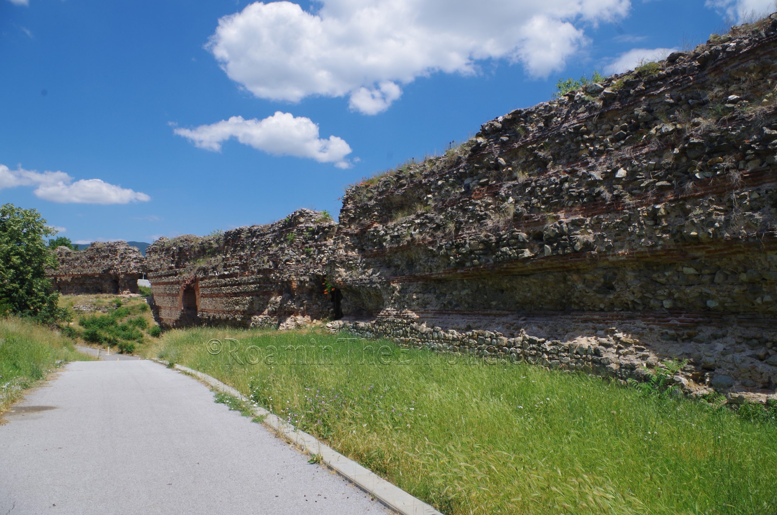
Approaching the walls from the north, one thing that is readily apparent is that there isn’t actually just one circuit of walls here, but rather two. One runs right along the edge of the road, while a second and more robust line of fortifications, with intermittent square towers, runs a few meters to the south. These southernmost fortifications, along with the rest of the primary fortifications of the city, probably date to the reign of Diocletian, immediately following the Gothic Wars which saw Gothic incursion into Thrace. There was perhaps an earlier circuit of walls dated to the late 2nd century CE, but no physical evidence of these has been found. The west, south, and eastern sides of the city have natural and constructed depressions that helped with the defensive capabilities of those sides of Diocletianopolis. The northern side had no such topographical advantages. After the Hun invasions of the 5th century CE, in which the northern gate was destroyed and later rebuilt, this smaller proteichisma wall was built along the northern side of the city to supplement the original 3rd century CE fortifications.
Just a few meters east of where Ivan Vazov Boulevard intersects with Hristo Botev Boulevard (roughly where one would end up if coming from the bus stop or railway station) is the north gate of Diocletianopolis. The two closely spaced towers are the biggest indication of the gate. The entrance is also preserved as a gap in both the wall circuits. The low level of preservation of the walls here makes it possibly the least impressive and certainly the mostly poorly preserved of the city’s main gates. Ivan Vazov Boulevard is one of two roads that crosses the walls and into the interior of the ancient city from the north. And one of just a few roads that cross the walls at all, which are mostly complete in their 2.3 kilometer circuit around the area of the ancient city.
The preservation of the main walls along the northwestern side is relatively low, about a meter at most. The form of both walls and the towers are very clear and well preserved, though. About 250 meters west/southwest of Ivan Vazov Boulevard, the walls cut to the south/southeast and a footpath continues along the exterior circuit. The walls along the west side of Diocletianopolis are preserved at a much greater height; as high as 13 meters in some places. The towers on the west side, though, are preserved at about the height of those on the north side, just about a meter or so.
The walls at the northwest don’t run exactly perpendicular relative to the northern walls, but rather they angle slightly to the east for about 200 meters until the area of the west gate. The west gate is often described as the best preserved of Diocletianopolis’ gates. The arch over the gate is intact and preserved to just over 13 meters, and the walls on either side are also fairly intact and mostly preserved to their original height. From the west gate, the walls then bow back out to the west at a slightly sharper angle. This section of the walls runs for about 165 meters before it meets back up with what would have been a straight perpendicular line of the walls from the northwest corner. So the effect is that the walls bow in toward the west gate before returning to the original axis. Then, the walls bow in again ever so slightly toward the southwestern corner. The walls at the southwestern part of the circuit, however, are not very well preserved.
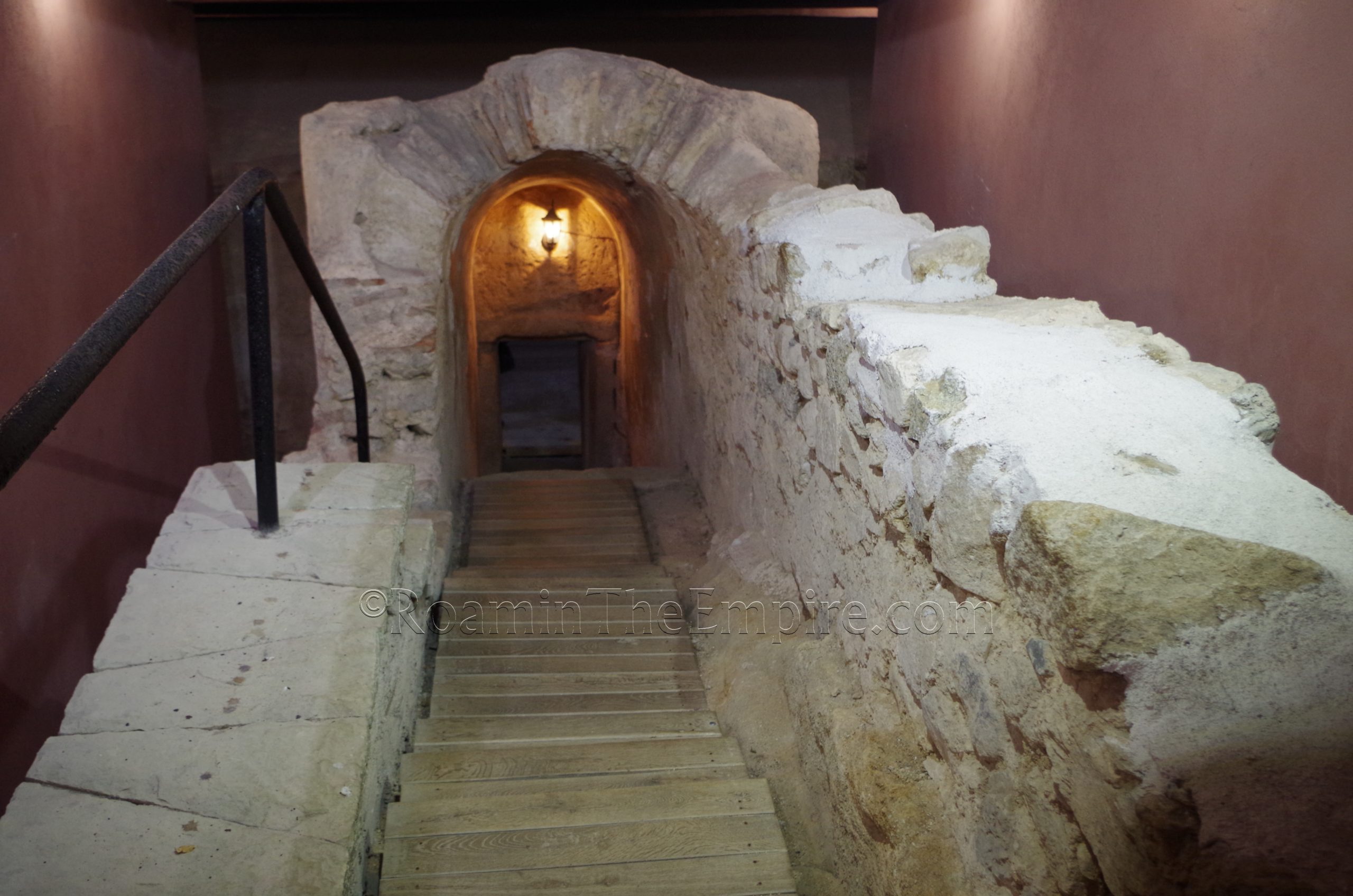
Once at the southwest corner of the walls, there is a marked path toward the south that leads off to the Roman Tomb. It’s about 325 meters of walking to the tomb, which is also accessible by vehicle via a road to the west. The tomb is open daily from 9:30 to 13:00 and 14:00 to 17:30. A single admission is 3 Lev, but a combination ticket that includes the archaeological museum and the baths is also available for 7 Lev.

The Roman tomb here is one of several that were found in the area (among 5 necropolis), officially identified as Tomb No. 3. This, however, is the largest of the tombs found and the only one that is open and accessible to the public. It was built in the second half of the 4th century CE. From the outside, the tomb is distinguishable as a mound, though this seems to be mostly a function of the small building constructed to serve as a shop and ticket counter at the entrance to the tomb, rather than as housing the tomb itself. Descending into the tomb, the entryway of the structure is pretty well preserved, though the originally steps are overlaid with modern wood.
A number of decorative elements of the tomb are preserved and visible, apparently the only tomb of Diocletianopolis with such features. Some wall paintings, though faded, are certainly distinguishable. Including some roses painted on the interior of one of the funerary niches, supposedly the earliest depiction of a rose in Bulgaria. Geometric mosaic flooring has also been preserved. There were apparently two phases of burial here, the first being cremation burials that made use of the niches. Later, there were also two inhumation burials that made use of the pair of beds that were constructed after the original construction of the tomb.

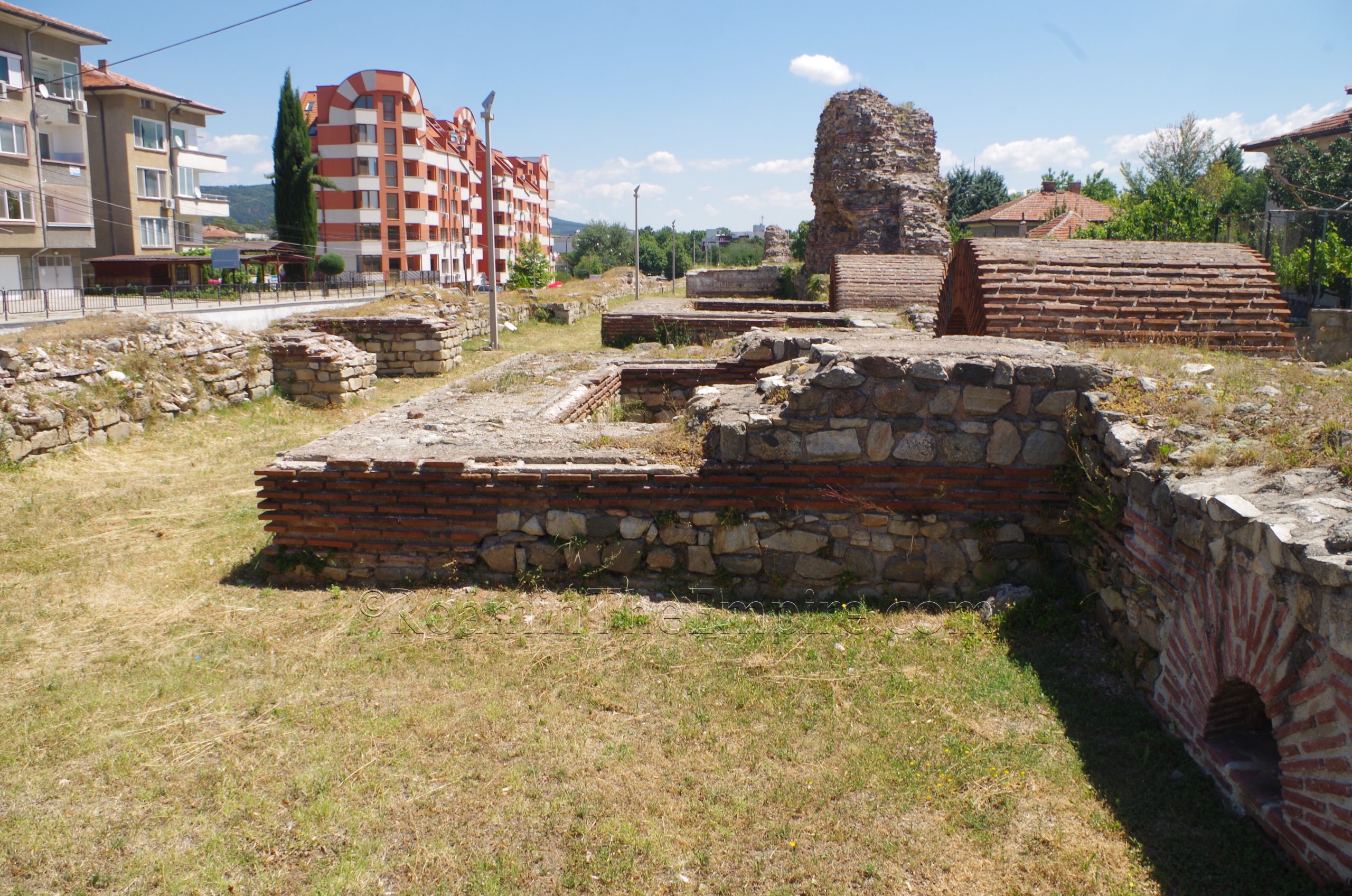
Heading back to the walls from the Roman Tomb, the southwestern section of the southern walls are preserved at a greater height than the north, but significantly lower than the northern segment of the western walls. There were actually two gates along the southern circuit of walls. The first is located where the walls dip to meet the depression in the landscape opposite the path to the Roman tomb. Nothing of the actual gate is visible other than a small gap in the walls. This first of two gates on the southern circuit of the walls is only about 40 meters from the southwest corner. And like the western gate, the walls on either side of it bow northward to meet it.
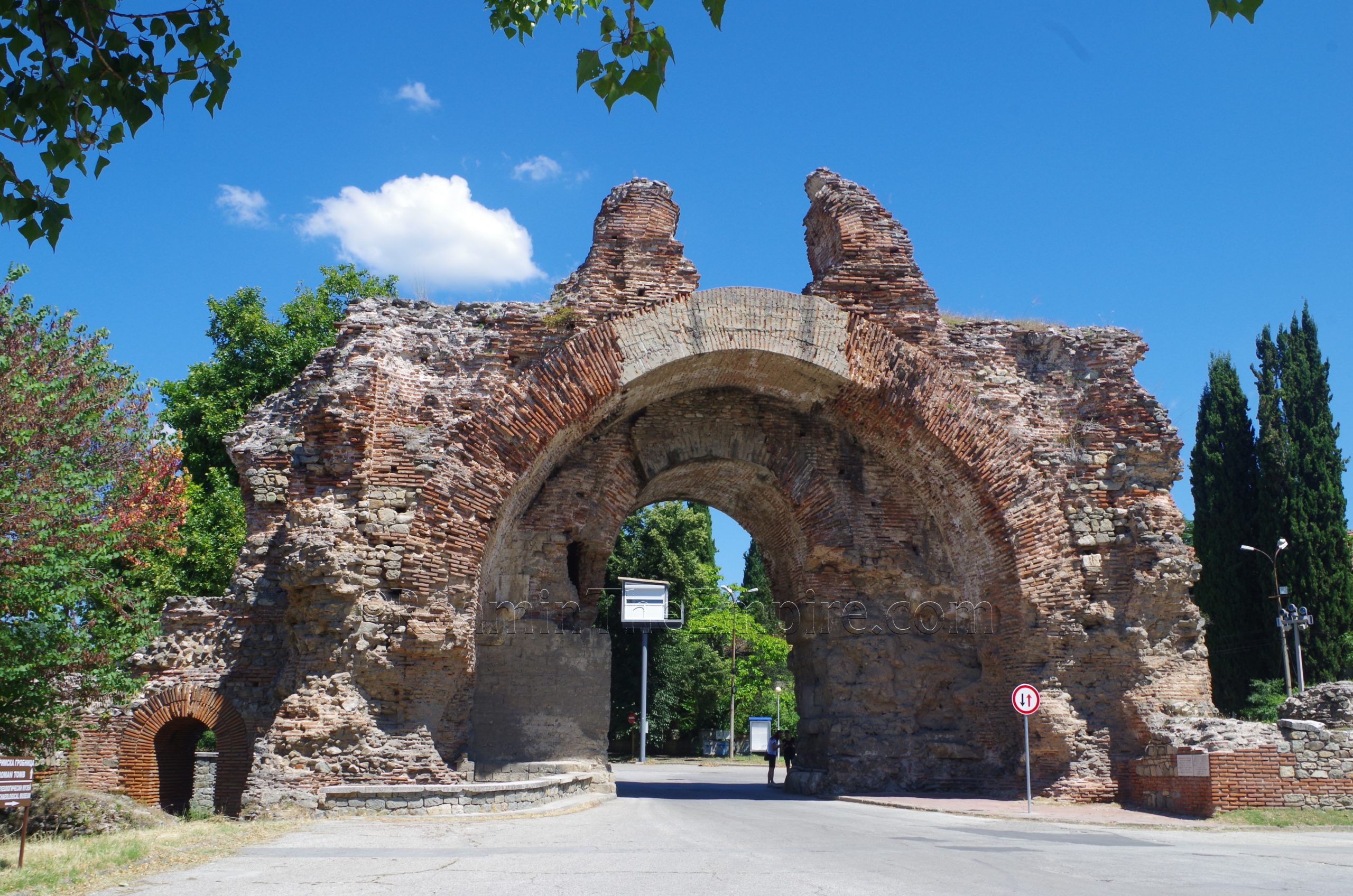
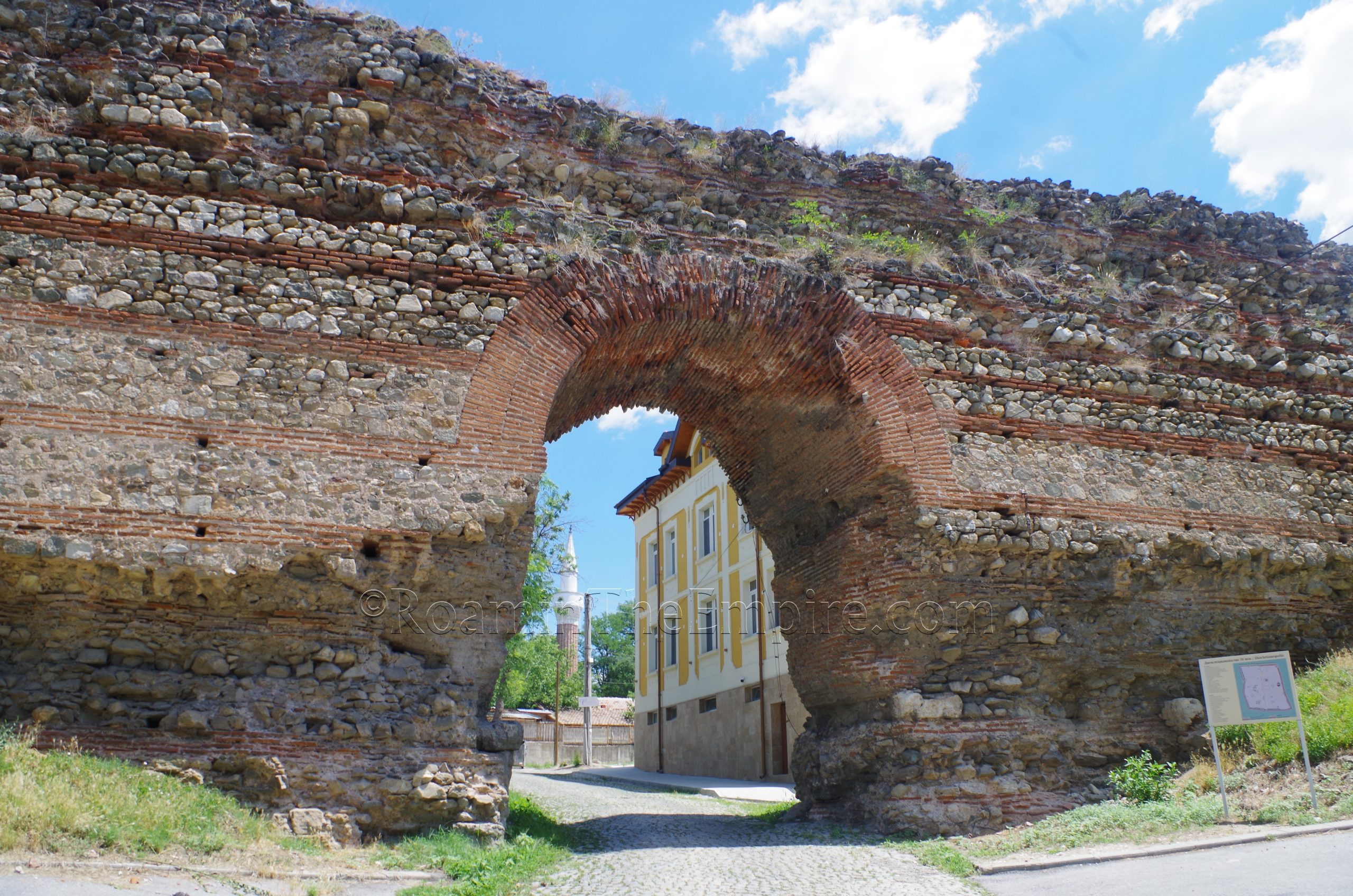
About 170 meters on from this first gate in the southern walls, is the second and primary southern gate. This gate, the so-called ‘Camel Gate’ is one of the most recognizable features of the ancient city. It gets its name from the two projections atop the gate, remnants of an upper arch, which now resemble the humps of a camel. The construction of this gate does not date to the original late 3rd century CE construction of the walls, but rather to a late 4th century phase of construction that was concerned with repairs to the existing wall and also included the construction of this new gate. Its structure is more elaborate than the other gates, certainly when compared to the mostly intact western gate. The presence of the additional arch atop the entrance seems to indicate some kind of defensive tower structure. The entry is much wider than the other gates and niches are present for the display of statues. The road emanating from this gate continued on toward Philippopolis (Plovdiv). There is a nearby sign with information in Bulgarian, Russian, English, and German.
Continued in Diocletianopolis, Thracia – Part II


Sources:
Ivanov, Alexander. Spectacle Buildings in Late Antiquity from Bulgaria. Bulgarian Academy of Sciences, November 23, 2022.
Manev, Alexander. The Fortification System of Diocletianopolis During Late Antiquity. Bulgarian Academy of Sciences, November 24, 2022.
Smith, William. Dictionary of Greek and Roman Geography. Walton & Murray, 1870.
One thought on “Diocletianopolis, Thracia – Part I”
Comments are closed.