


Continued From Aptera Part I
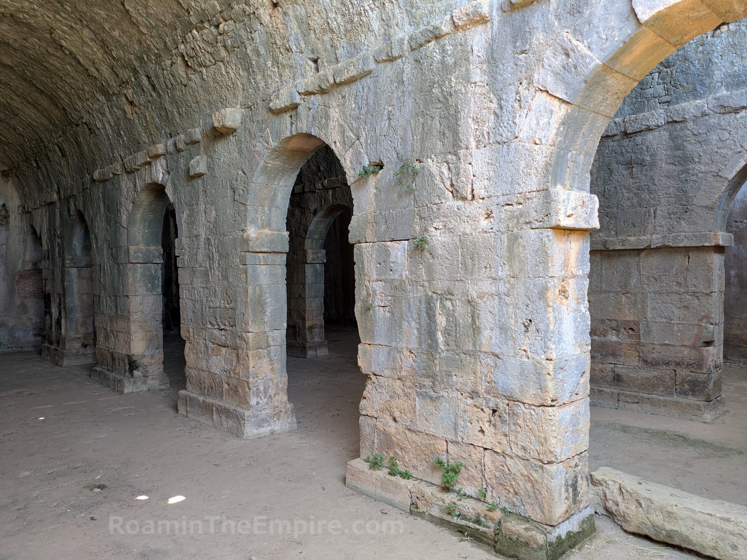
The cisterns that supplied the Baths I are located just a few meters from the south end of the bathing complex, though the remnants of that part of the baths are sparse. These covered cisterns are perhaps the main attraction of the site, with the vaulted roofs of the three chambers still mostly intact. The cisterns seem to date from perhaps as early as the 3rd century BCE originally, with later embellishments and repairs being made in the early Roman period. The capacity of these cisterns is estimated to have been about 2,900 cubic meters. Elements of the channel from which water was drawn are visible in the easternmost part of the cisterns.
The cisterns are partially constructed into the slope of a hill, and a stairway leads to a crest up above the cistern and a plateau on which the southern parts of the site are located. There is a small excavated area adjacent to the top of the path leading from the cisterns. A few well-defined walls as well as a small portable basin and column fragment are present, but there doesn’t seem to be any information as to the identification or dating of the material.
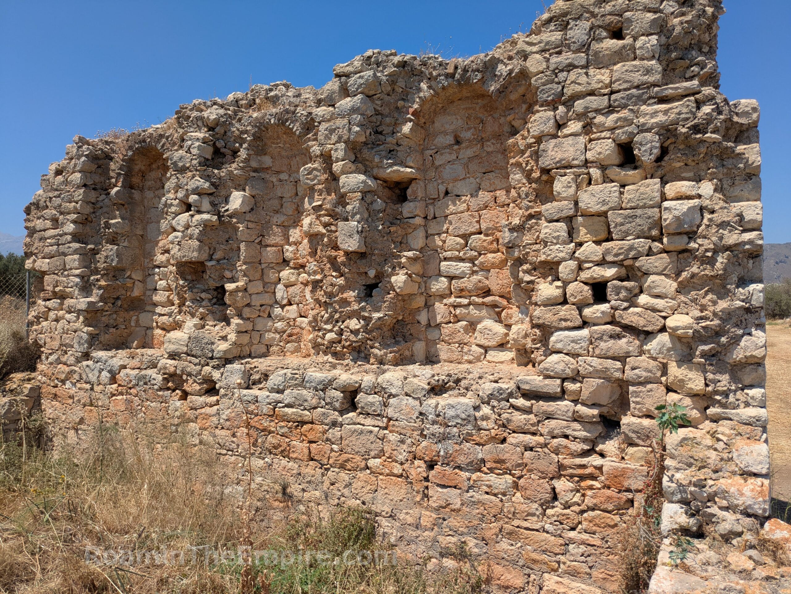
Sixty five meters to the southeast is a lone wall with some interior niches in the eastern face. The foundations of other walls are visible, but it is this west wall of a rectangular building that is preserved to a height of a couple meters. This building has been very generally identified as a Roman period public building. It has been posited that it could possibly have functioned as the bouleuterion.
To the west of the public building, more or less at the center of the archaeological site, is the large restored 12th century CE Monastery of St. John the Theologian. According to information on site, elements of ancient Aptera were employed in the construction. There are supposedly a few inscriptions built into the walls of the monastery, but several circuits around all the publicly accessible areas did not reveal any visible inscriptions. The monastery also hosts some informational exhibitions for the site as well as the site facilities such as the restroom. In the west part of the courtyard is a pile of stone ball projectiles that were found at the main gate of the site.
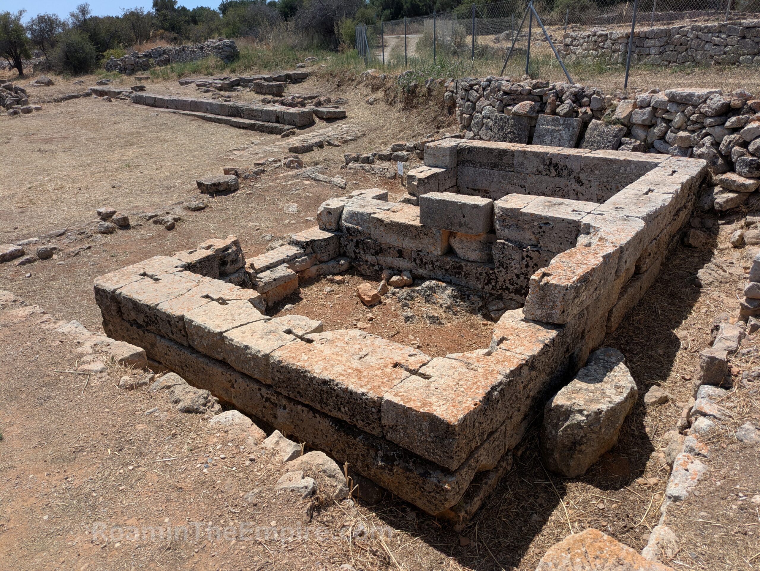
Almost immediately to the southwest of the monastery, near the entrance to the site is the so-called two room temple. A few courses of ashlar blocks are preserved for the small rectangular structure that is subdivided into two equal sized rooms. This temple is estimated to have been constructed in the 5th century BCE, making it the earliest structure preserved at Aptera. A sanctuary probably existed on the spot dating back to the foundation of the city in the 8th century BCE. The temple was entered into from the east and it is surmised that Artemis and Apollo may have been jointly worshiped here in the Classical period. It is in this area that a now lost wall of inscriptions recording resolutions of the boule was believed to have been located. Such a monument likely would have been placed adjacent to Aptera’s main sanctuary, which probably would have been dedicated to Artemis given her connection to the city.
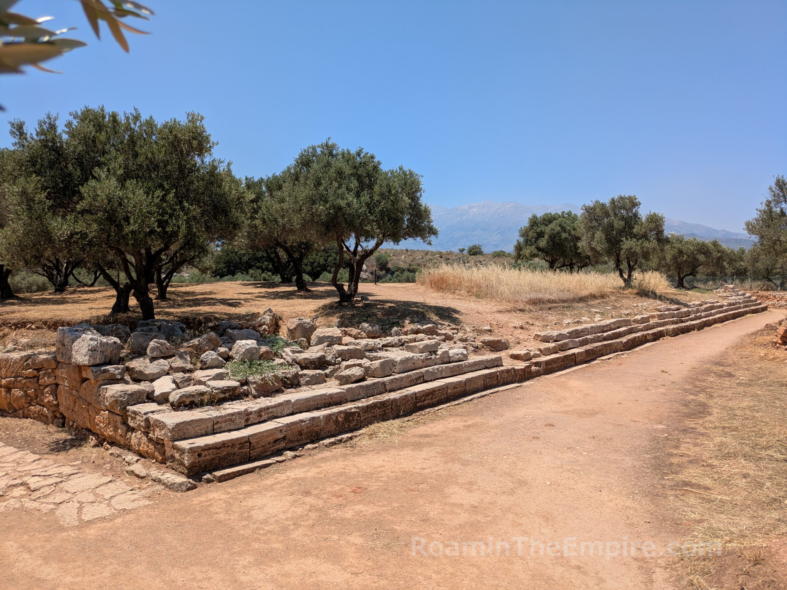
The remnants of a small enclosure wall are visible a meter or so to the east. The altar of the temple would have been located somewhere in this space between the enclosure wall and the temple. Adjacent to the southeast send of the enclosure wall is a flat, rectangular patch of stones. These are the remnants of a road which lead from this sanctuary toward the theater. Just beyond that are the stepped blocks of a stylobate that stretch for about 20 meters toward the east. The stylobate probably belonged to a stoa that ran along the south side of the sanctuary area.
The temple wraps up the main area of the site, but there is one more area to the south. It’s a bit of a strange situation because it’s outside the fenced area of the main part of the site and within a separate fenced section that is accessible by a path just to the east of the ticket booth. There isn’t a lot of signage to indicate that the theater is located about 125 meters down that path. When I first visited the site in 2014, the theater environs were still being excavated and could not be visited, but it was open in 2025.
Upon approaching the area of the theater, the path splits off in two directions. To the southeast, the path is partially paved with an ancient road. Along the southwestern path is a stepped stone structure. Only two steps are visible at the eastern extent, but a third becomes visible continuing along to the southwest, and finally at the southwestern extent, several more are preserved. This roughly 50 meter long structure is the so-called rectilinear theater. It was built in the first half of the 3rd century BCE, shortly after the main theater, and may have served in part as a retaining wall for the main theater. Originally it consisted of 11-13 rows of seating with four staircases (still discernable) dividing the seating into more or less equal sections and is estimated to have held 600-700 spectators. It is similar in form to older Minoan theaters, and may have served a religious function. The form is similar to other cult spaces related to chthonic deities, so it may have been used in that capacity and additionally been employed for other religious or civic uses.
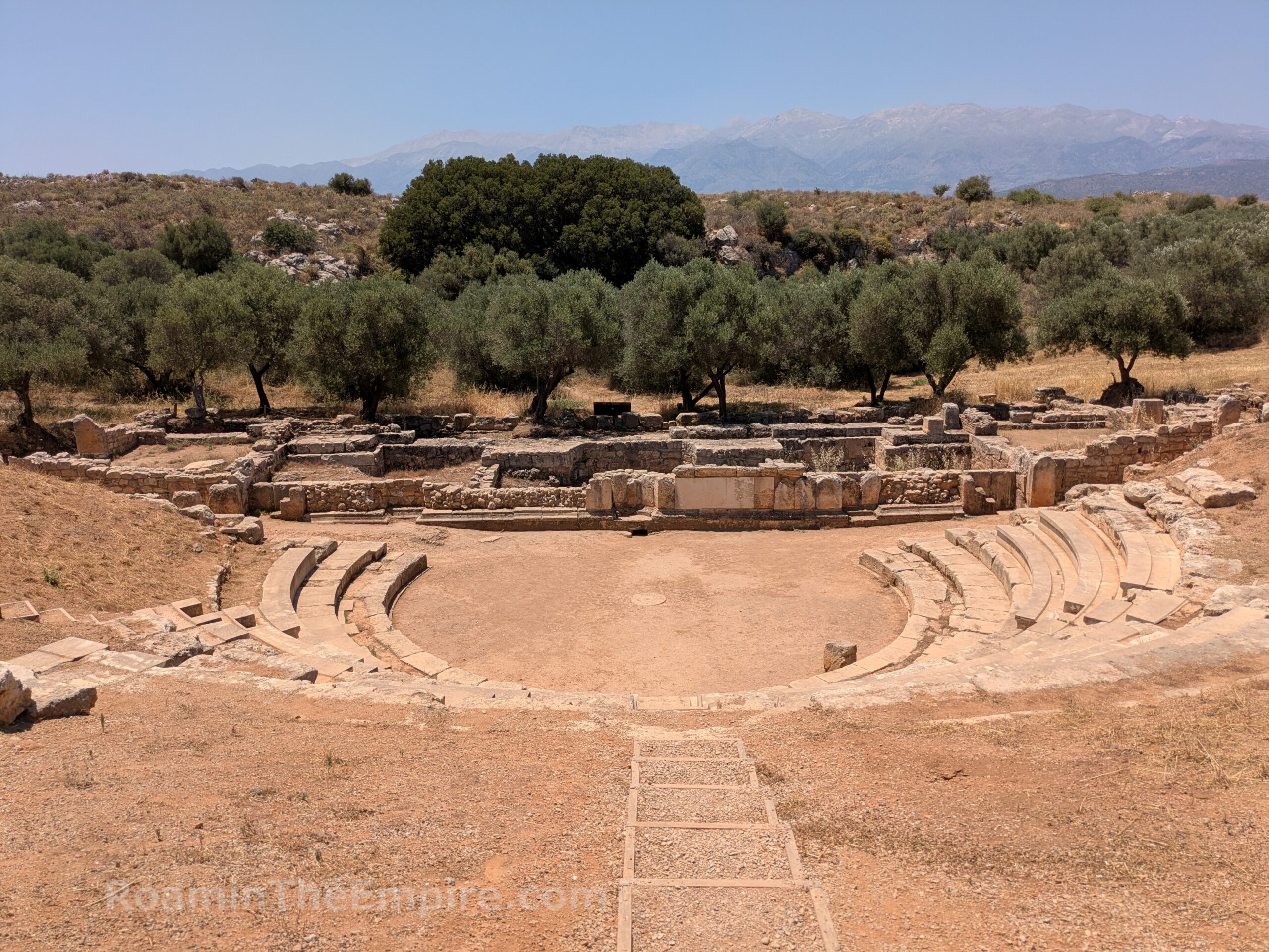
The actual theater can be accessed by either continuing along the path to the west, doubling back to the ancient road on the east, or going straight over the top of the rectilinear theater to the south, which leads to the top of the remaining cavea of the theater. It was originally constructed in the first half of the 3rd century BCE. During the 1st century CE it underwent a building phase that included the renovation and expansion of the cavea, the replacement of the stage buildings, and the lowering of the orchestra floor level. A third building phase of uncertain dating occurred after this during which the lower cavea and stage buildings were remodeled and other minor alterations were made, resulting in the form of the theater that exists today.
The theater of Aptera had 26 rows of seating in its third phase and final phase of construction, of which the remnants of 11 still remain. The freestanding structure of the theater was built well above what is now the highest level remaining of the supporting landscape of the seating area. The foundations of the scenae are relatively well preserved and mostly date to the Roman period, though remnants of the rear wall of the Hellenistic stage building can be seen uncovered at the south side of the later scenae. Robust retaining walls along the paradoi at both the east and west sides of the theater.
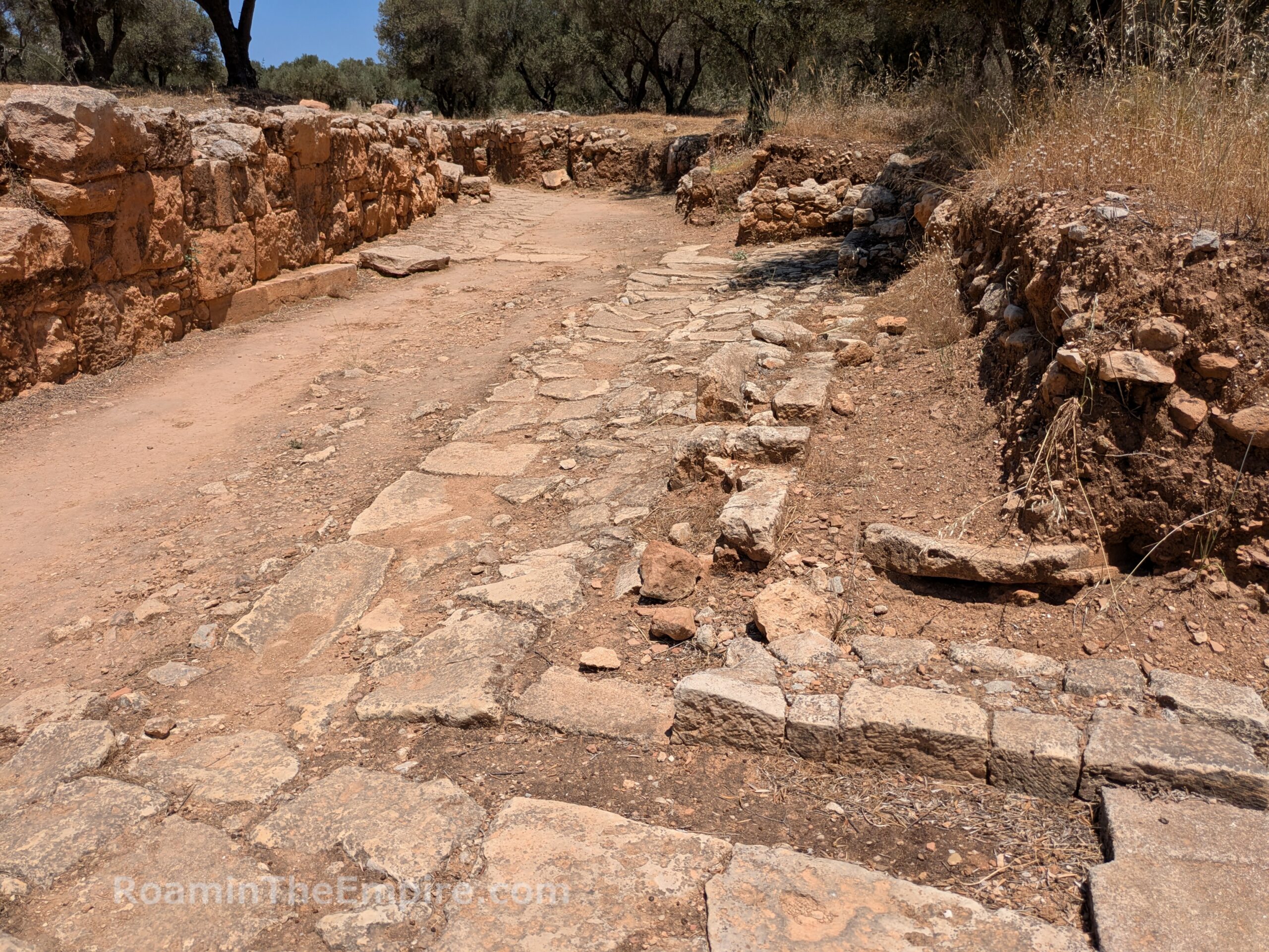
A road and a drainage channel dating to the Hellenistic period run up the slope and through the west parados of the theater. Outside of the east parados of the theater, another Hellenistic road runs along the ancient retaining wall along that side of the theater. This seems to be the same road that is visible near the two room temple. Just outside the east parados, along the east side of the Hellenistic road are some sparse foundations walls of a Hellenistic building that lined that side of the road. The function of the building is not known. The Hellenistic road continues along intermittently to the north for about 50 meters before intersecting with the area of the rectilinear theater.
The theater concludes the archaeological remains of Aptera within the archaeological park. In total, I spent about 2 hours inside the ticketed archaeological area. Most of the points of interest have basic identification signs in Greek and English. They looked fairly new for the most part. A few points of interest had more extensive information boards in both Greek and English as well as illustrations and diagrams to add context. Again there are further, more detailed information presentations in the monastery that discuss the history of the site and the monuments in a little more detail. I thought the admission price was objectively a little steep at 10 Euros, but honestly about par for what prices on Crete were when I visited in 2025.
The main road that leads from the modern village of Aptera to the site continues on to the northeast past the turnoff to the site. About 200 meters down this is a crumbling bit of wall in a small field on the north side of the road. It’s unclear what this wall belonged to, but it does bear some resemblance to the Baths II complex. At the top of the wall, some curving is perceptible, indicating it had a vaulted ceiling. A pile of larger fragments of walls sits on the north side of the more complete part of the wall that is preserved to a significant height. The area is somewhat fenced, it looks to be adjacent or part of someone’s animal enclosure. The brush along the road does a better job of preventing direct access than the fence does, though.
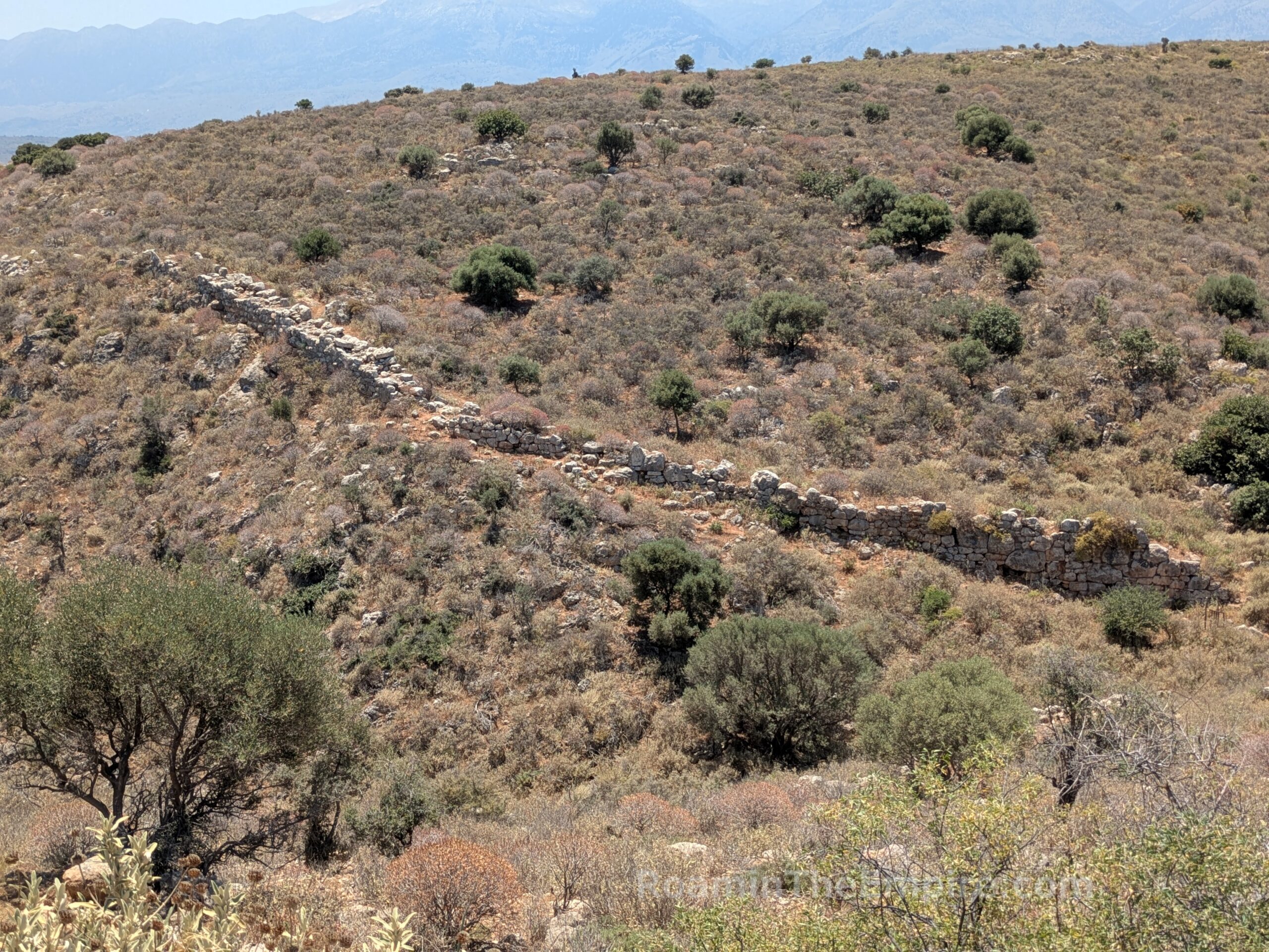
At the end of the road, another 500 meters or so farther, is the 19th century CE Koules Ottoman Fortress. Across a ravine to the south of the fortress on the opposite ridge are the remnants of the eastern fortification walls of Aptera. The fortifications of Aptera were constructed in the 4th century BCE and had a total circuit of about 3.5 kilometers. The walls actually start on the side of the same ridge as the fortress, and so also enclosed the ridge on which the fortress sits. A path about 40 meters past the parking lot area of the fortress leads through a gate and down into the ravine along the top of the remnants of the wall. The walls then climb back up the ridge opposite the fortress. The path continues along this leg of the fortifications. At the top of the ridge, they swing southward and continue on for around another 500 meters or so, at least. I didn’t walk the total remaining circuit in this part of the city, but they’re visible from satellite images.
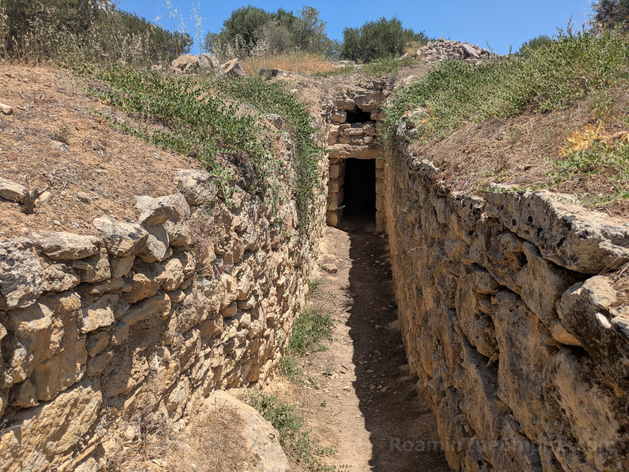
The fortification walls in addition to the west gate, necropolis, and Roman house add another half an hour or so on to the two hours in the archaeological park; depending on how much of the walls you explore. Also depending on whether you have a vehicle. It’s also worth noting that there are a few vestiges of the earlier settlement located about 4 kilometers away by vehicle. A vaulted tholos tomb dating to the 15th-14th century BCE is located along the road between modern Aptera and Stilos. An unlocked gate and informational side alongside the road, opposite a small parking area, indicate the location. It is an otherwise unsupervised site and there is direct access to the interior of the tomb. The tomb is in very good condition and well taken care of with a mostly intact roof. A little farther along the road are the remnants of the Minoan settlement, which include a kiln as well as some Archaic period buildings. I was unable to get through the fence to this site, though, and can’t comment on accessibility or preservation.


Sources:
Ninious-Kinteli, Vanna. Aptera. Ministry of Culture 25th Ephorate of Prehistoric and Classical Antiquities,
Pausanias. Hellados Periegesis, 4.20.8, 9.34.3.
Pliny the Elder. Historia Naturalis, 4.59.
Polybius. Historia, 4.55.3.
Smith, William. Dictionary of Greek and Roman Geography. Walton & Murray, 1870.
Strabo. Geographica, 10.4.13.
Stillwell, Richard, William L. MacDonald, and Marian Holland. McAllister. The Princeton Encyclopedia of Classical Sites. Princeton, NJ: Princeton U Press, 1976.
Tzanakaki, Katerina. Aptera, a City of Crete. Hellenic Ministry of Culture and Sports, 2019.