


For this week’s post, I’m going with another round up of some miscellaneous sites in Sardinia. This route can generally be described as the northern part of central Sardinia, roughly the northern part of the Oristano region and the Nuoro region. To see most, if not all, of the sites, a personal vehicle is pretty essential.
The first stop on this itinerary is the Punic/Roman settlement of Cornus. Cornus seems to have been founded near the end of the 6th century BCE, probably as part of the Carthaginian consolidation of the agricultural hinterland of Tharros, which is about 25 kilometers away. Cornus doesn’t really appear in the historical record save for an episode in the Second Punic War. A Sardinian-Punic magistrate of Cornus named Hampsicora, spurred by the victories of Hannibal in Italy, led a revolt of the Sardinian coastal cities, many of whom were still sympathetic to the Carthaginians, against Rome in 215 BCE. After securing the support of many of the indigenous Sardinians in the interior of the island, Hampsicora sent for support from Carthage. Before the Carthaginians arrived, the Roman consul Titus Manlius Torquatus set out for Cornus, near where a small army commanded by Hampsicora’s son, Hiostus, had camped. The ensuing battle ended in favor of the Romans, but the arrival of the Carthaginian army at Tharros prevented Torquatus from attacking Cornus, and instead Torquatus withdrew to Caralis. A subsequent battle and Roman victory near Decimum put an end to the revolt.
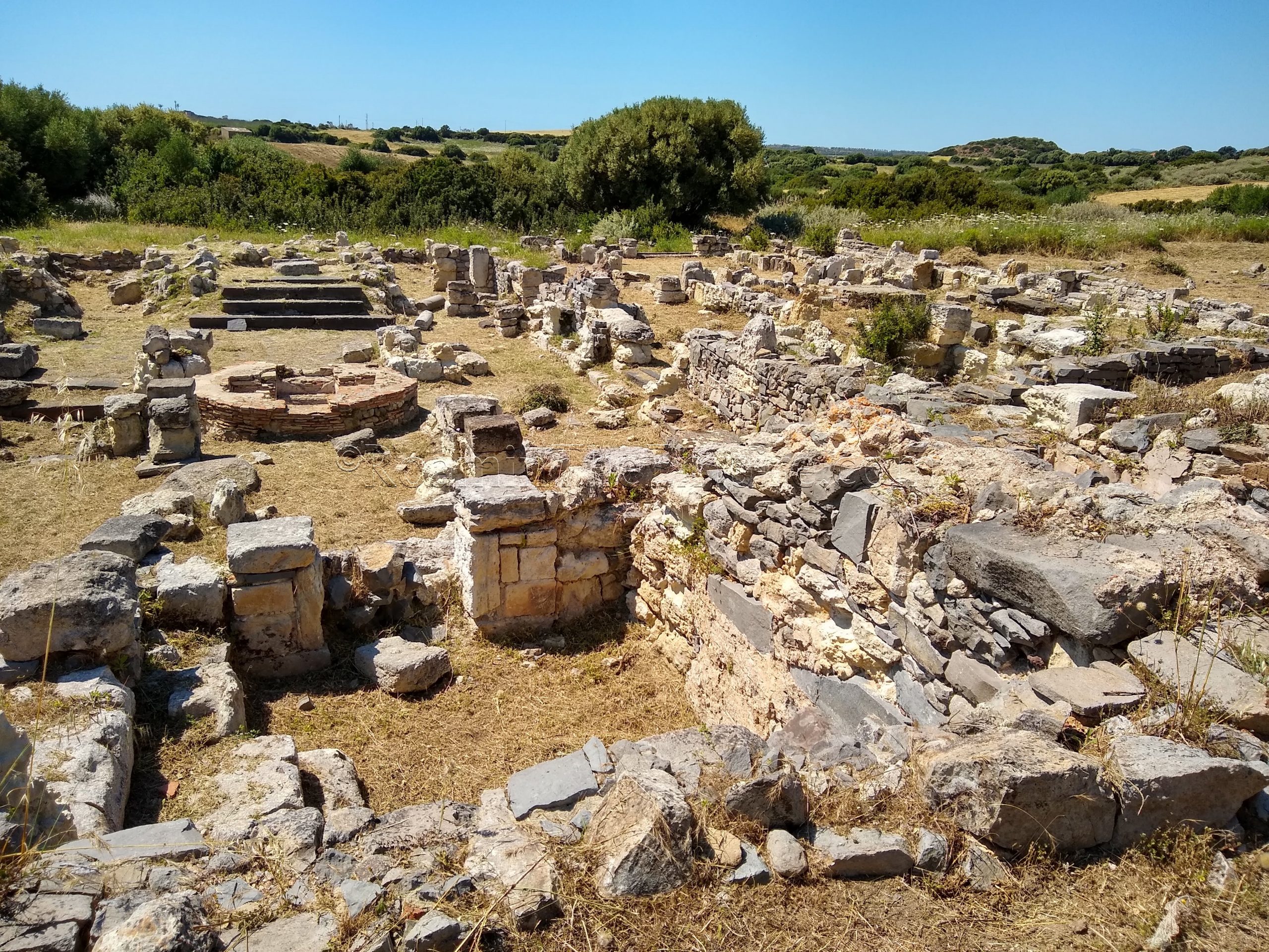
The original location of Cornus is atop a hill to the southeast of the town of S’Archittu. Not much is excavated at that location and there doesn’t seem to be any real access to the area. Some elements of a northern neighborhood of the Roman era settlement remain, however, at the Rovine di Cornus – Columbaris (Basiliche di Cornus). The archaeological area does not seem to have any regular opening hours; I just happened to show up at a time when they were holding some sort of special opening, I think (afternoon of the 1st Sunday in June). Otherwise, the site is fenced off and gated, so while one could view the site through the fences, there is no access. Though the area was the location of a bathing complex in the 3rd century CE, a series of three Paleochristian basilicas were constructed in the 4th and 5th century CE. The focus of the site is the basilicas, and there doesn’t seem to be any visible traces of the baths.
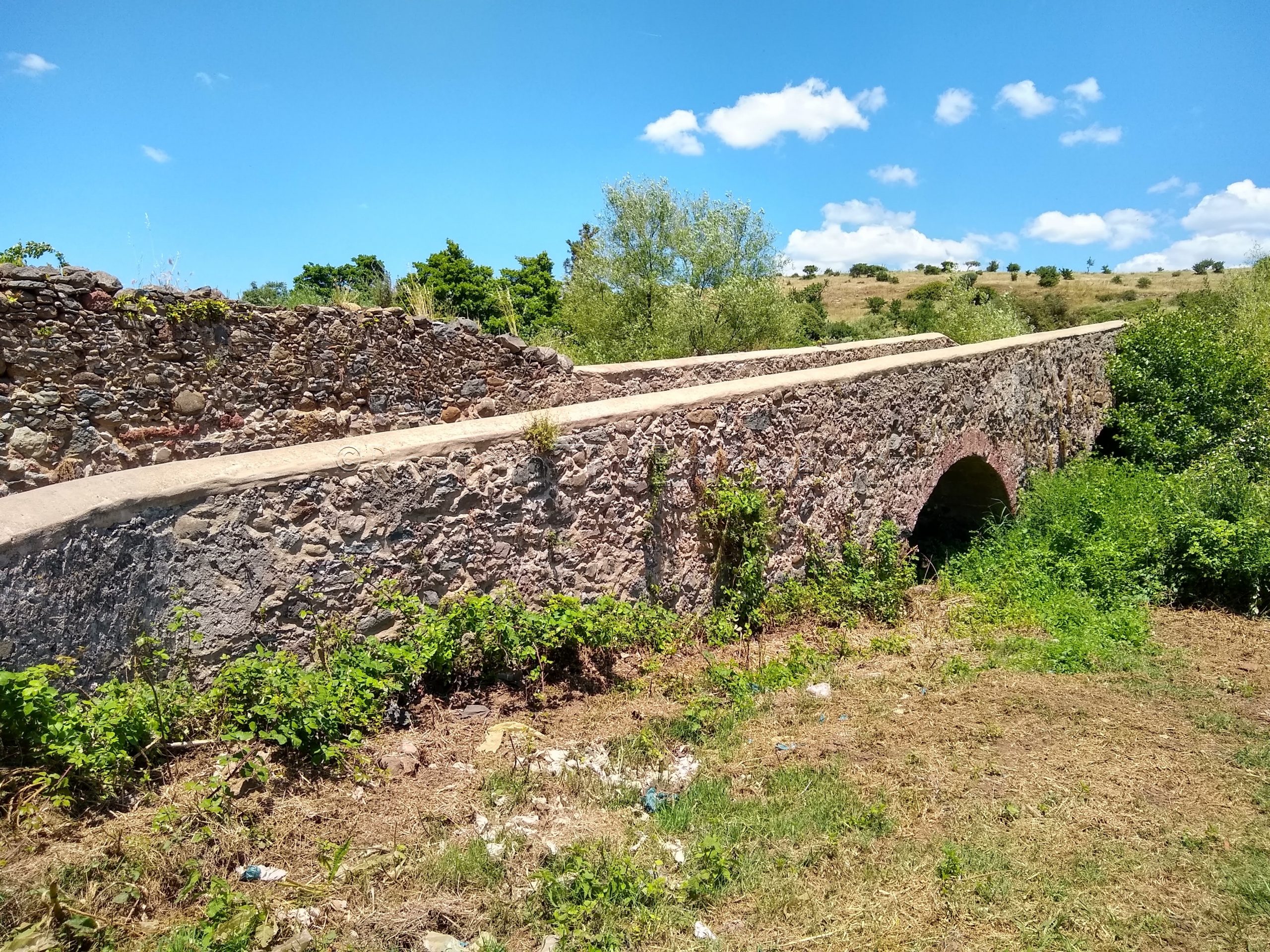
Not far from Cornus, a few minutes south of S’Archittu, is the Ponte Romanu de su Riu Ozzana, a Roman bridge over the Ozzana River. Incidentally, at the turnoff to the dirt road that leads to the bridge, in front of the Villaggio le Dune resort, is the Stele di Amsicora, a small monument to the Sardinian leader who led the rebellion against the Romans (see above). Down the dirt road is the bridge. Unfortunately, not much can be seen aside from the actual surface of the bridge (which is visibly dirt at this point). The areas on either side are fenced off, preventing one from descending to the area below from right around the bridge (it was quite overgrown). I’ve read that the best way to actually see the structure of the bridge is to hike the river gorge from the beach area, where the private land surrounding it does not prevent access. There isn’t much to see if you don’t do that, though.
Roughly 25 kilometers away, near the town of Bonarcado, is the Ponte Etzu. The actual dating of the construction of the bridge is somewhat unknown. The Ponte Etzu is sometimes claimed to be of Roman origin, but likely has a later construction date. Between the 7th and 10th centuries CE seems to be the most likely dating for the bridge. It does, admittedly, look later, but it is certainly possible that elements of it date to the Roman period, or that there was a more ancient bridge at that location at one point.
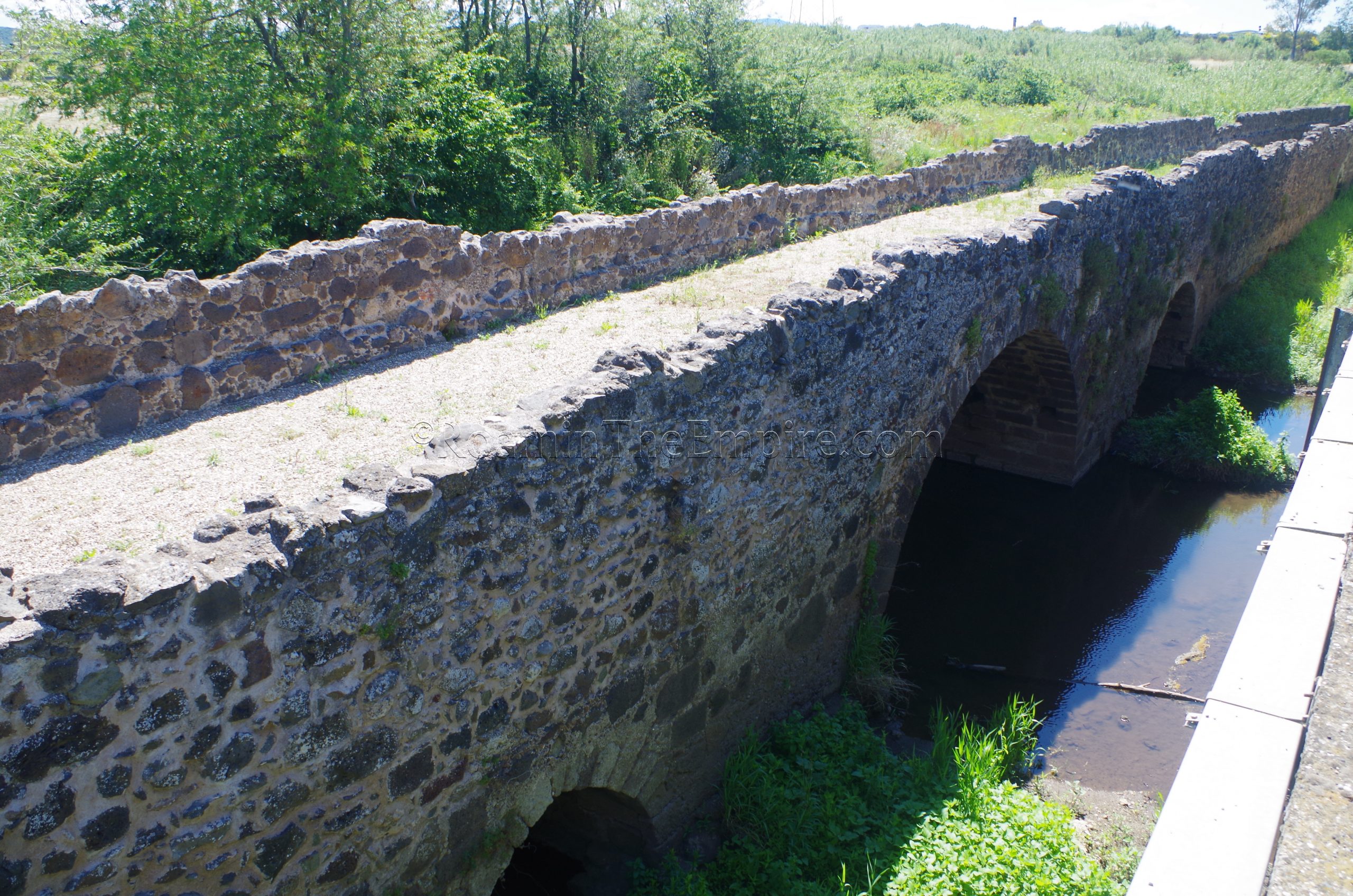
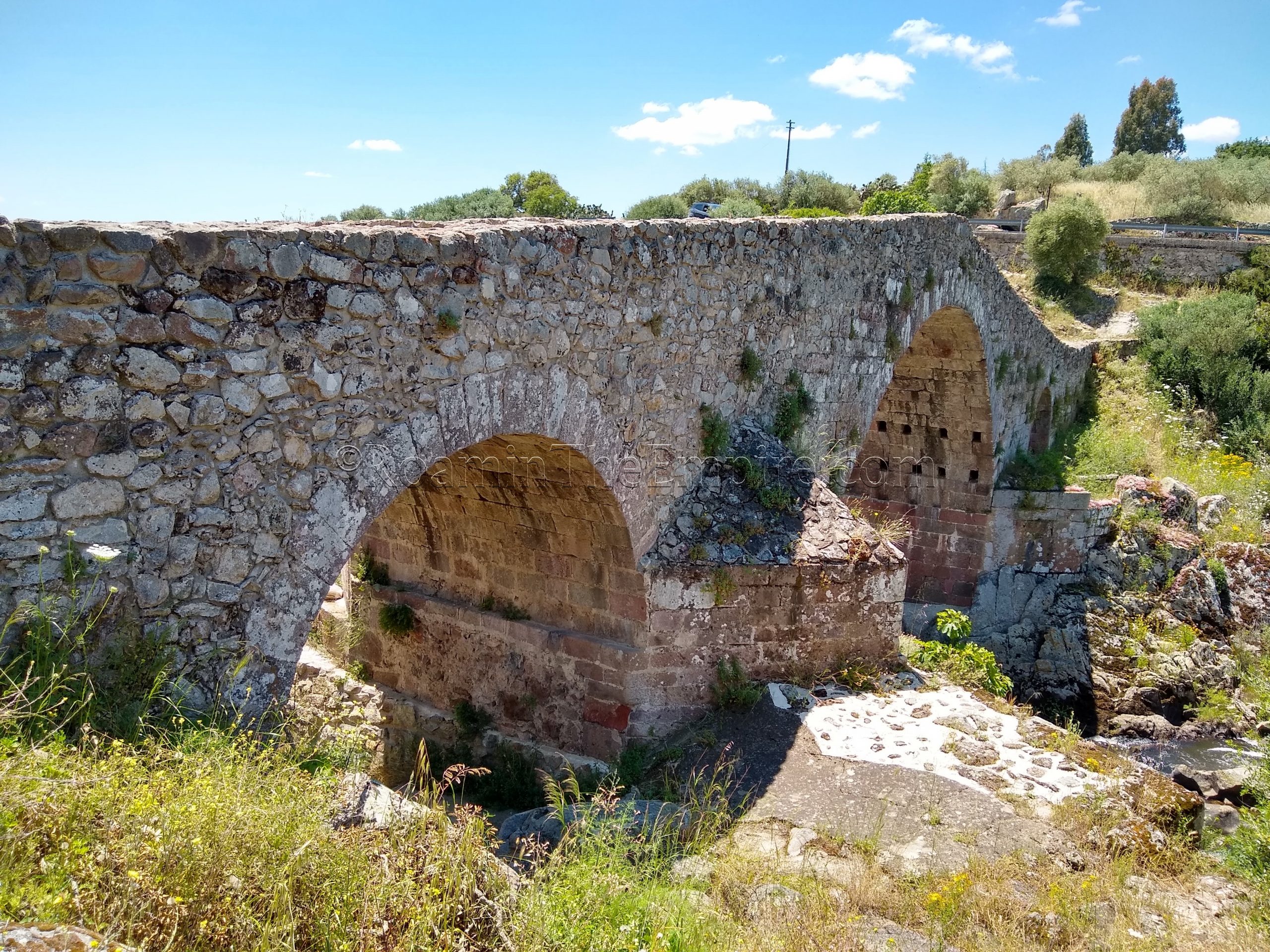
A much better and more accessible example of a Roman bridge than the previous two stands about 13 kilometers to the south, down the SP15, outside the town of Tramatza. Just off the E25, the main north-south route through the island, outside the southern edge of Tramatza, the Ponte Romano spans the Riu di Mare Foghe. Built in the late 1st century BCE or early 1st century CE, the ancient bridge carried traffic (including auto traffic) over the river until the 1970’s. In antiquity, it was part of a route between Cornus and Forum Traiani. The modern bridge and Roman bridge are now separated by just a few meters, which allows for pretty good views of the bridge from the west. The Ponte Roman is about 205 meters long and can today be traversed on foot. There were heavy restorations in the middle ages (the paving surface is significantly replaced) and in the 19th century. There is a small sign on site identifying the bridge and its time period, but no info beyond that.
Just a quick 10 minute drive up the E25 is the Parco Archeologico Naturalistico di Santa Cristina. The archaeological park opens at 8:30 and remains open until sunset, usually about 19:30 in the summer. Admission is 5 Euros, and guided visits are available on the half hour. The Santa Cristina Archaeological Park is primarily a Nuragic site, which is something certainly worth checking out on its own when visiting Sardinia. The Nuragic culture is a huge part of the historical and archaeological fabric of the island. The park is essentially divided into three parts. On the eastern side is the Pozzo Sacro di Santa Cristina; the sacred Nuragic well. The well dates to probably around the 12th century BCE and was the center of a sanctuary related to a water cult. Some ancillary buildings surround the well, which is in turn surrounded by an elliptical enclosure wall. The well itself is essentially a stairwell that descends into an underground chamber with a water source. During the equinoxes, the sun aligns with the opening to shine directly onto the water.
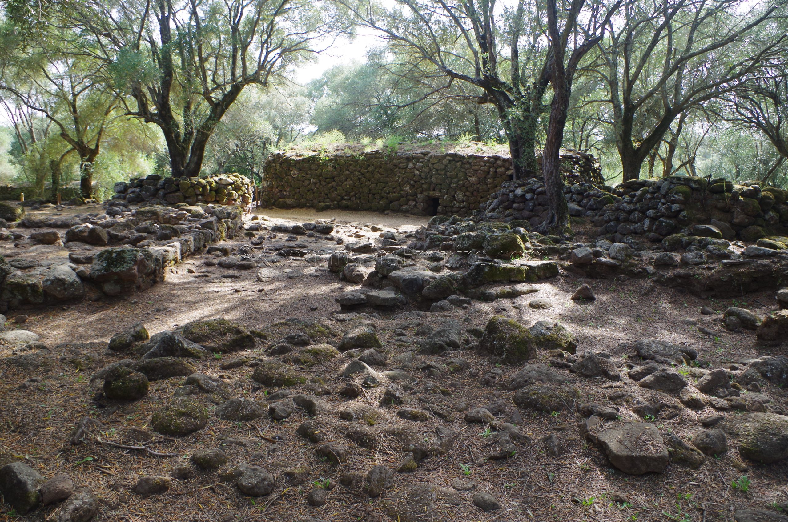
In the middle area is the Christian Village that gives its name to the entire site. The small village, centered on the 12th century CE Santa Cristina church, employs blocks spoliated from the Nuragic site in some of the buildings. The west side of the park is the site of the Nuragic village and the Nuraghe Santa Cristina, which one can climb up via the internal staircase. The Nuragic village seems to have been constructed between the 16th and 13th centuries BCE. Quite a bit of evidence exists that Nuragic sites continued to be used well into the Punic and Roman periods of occupation on the island, either through continued use by the indigenous people of the island, or re-purposed by the Phoenician/Carthaginians and Romans. Typically this evidence comes in the form of ceramics and other small objects found at the site. At the Santa Cristina site, though, an elongated hut to the north of the Nuraghe seems to have been constructed during the Roman period.
The Santa Cristina site, though not primarily Roman, is well worth the stop not only to see some good examples of pre-Phoenician/Punic Sardinian culture (a well-preserved well and Nuraghe at the same site), but to see how the usage of the site evolved over time. There are a few informational signs on-site with translations into several languages. Visiting took me a little under an hour to see everything here.
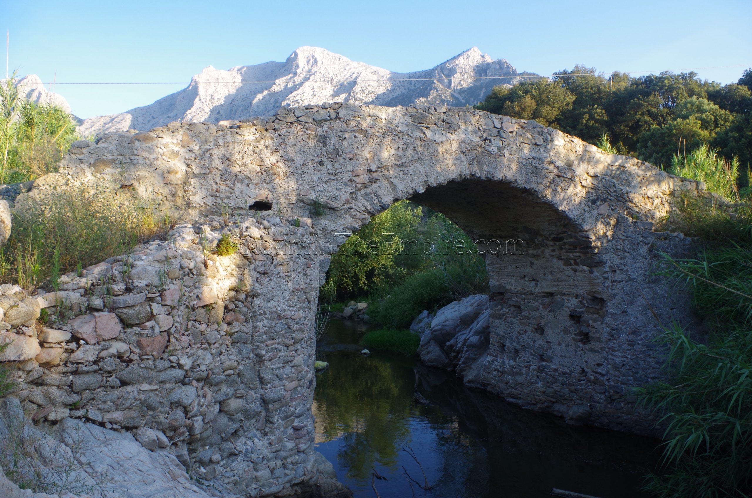
The next site is a bit of an outlier at about 80 kilometers to the east, past Nuoro near the town Oliena. In a rural area northeast of Oliena is the Ponte Romano di Pappaloppe. There doesn’t seem to be a whole lot of information on the bridge itself, but it is certainly of Roman origin.. The bridge has been poorly blocked off with some large rocks to attempt to deter traffic, but no less than half a dozen vehicles navigated around the rocks to traverse the bridge, which had a significant oil slick at its apex from all the traffic. Apparently the regular bridge upstream has been closed or severely limited to traffic for a few years, and this is the next closest crossing in the area. It’s quite a bit out of the otherwise pretty compact loop, but if you have reason to be out that way, it’s definitely worth the stop as the setting is quite picturesque. There is an archaeological museum in nearby Nuoro as well, though I was not able to visit it.
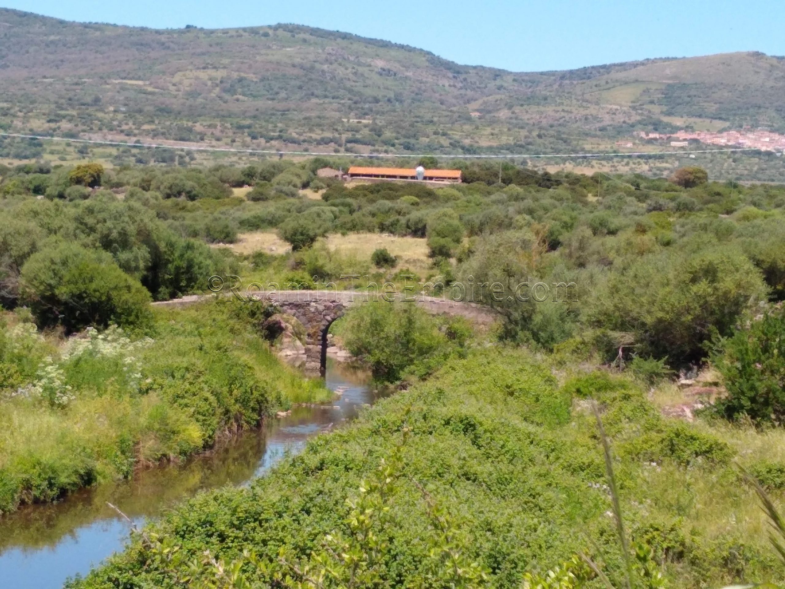
Heading back west about 44 kilometers is another bridge, this one in the vicinity of the town of Illorai. South of Illorai, just off the SS128bis, the Pont’Etzu spans the Tirso River (called the Thyrsus in antiquity). The sign noting the presence of the bridge designates it as a Roman bridge, but the actual origin may be later. The three arched bridge in its current form likely dates to about the 14th century CE and was the result of a reconstruction following the destruction of an earlier incarnation. The was almost certainly a Roman bridge at the location, and the 14th century CE bridge likely used existing elements and building materials from the Roman era bridge. The foundations of the piers, in particular, have a distinctly Roman look to them. The bridge is still in great condition and traversable on foot; and I wouldn’t be surprised if still sees some local auto traffic.
The last few stops on this itinerary are three bridges in the vicinity of Macomer, of which I had varying degrees of success finding/seeing. On a small road to the southeast of the town of Birori is a small three-arched Roman bridge crossing the Rio Murtazzolu. The bridge is visible from the road, particularly the modern bridge over the river. Unfortunately, I couldn’t find any access to get closer to the bridge. There are supposed to be trails out to the bridge from the modern road, but everything was quite overgrown; dry brush at least waist high. To double the disappointment, I was having issues with my camera that day and had to rely solely on my phone, which was less than ideal for zooming in on something nearly 150 meters away.
The next bridge is a short drive northwest to Macomer (Macopissa in antiquity), on the fringes of the north side of town. A Roman era bridge that spans the Rio S’Adde is attested to and visible on satellite imagery outside of town on the north, but I could not find any way to access it. The bridge is located in the center of an undeveloped area bounded by roads and railroad tracks, but, after driving around, I couldn’t locate any point that would offer access to the area by vehicle or by foot. Like the previous bridge, any place that did seem to offer halfway decent access on satellite imagery was quite overgrown. Perhaps later in the summer or at another time of year when the vegetation isn’t so thick, it might be more accessible.
The last stop is yet another bridge that, while definitely existing, was inaccessible. About 10 kilometers northwest of Macomer is the Ponte Romano Oinu, a Roman bridge over the Oinu River. Once again, though this bridge is clearly there, I could not find any sort of access to it. This one is even supposed to be part of a hiking area, the Ponte Sul Rio Mannu, but the trails that supposedly exist were overgrown to the point that I couldn’t even find them. Like the Birori bridge, the Ponte Romano Oinu is quite close to the modern road, only 120 meters from the SP44, but unlike the Birori bridge, the bridge was not visible from the modern road bridge. Quite a bit of foliage grows on the banks of the river, and anything even 20 meters from the bridge was pretty well obscured. Again, perhaps at a different time of year this bridge is more accessible, but, in early June I had no luck finding a means of getting to it.
The total route, including the bridge east of Nuoro and excluding the bridges with no access near Macomer, is about 200 kilometers. Given that most of the stops are pretty quick, this is an itinerary that is absolutely manageable in a single day. For the ambitious and/or early starters, a half a day would probably be pretty feasible.


.")


.")
.")
Sources:
Dyson, Stephen L. and Robert J. Rowland Jr. Archaeology and History in Sardinia from the Stone Age to the Middle Ages: Shepherds, Sailors, & Conquerors. Philadelphia: University of Pennsylvania Museum of Archaeology and Anthropology, 2007.
Livy. Ab Urbe Condita, 23.40.
Stillwell, Richard, William L. MacDonald, and Marian Holland. McAllister. The Princeton Encyclopedia of Classical Sites. Princeton, NJ: Princeton U Press, 1976.