


Most Recent Visit: June 2018.
Perhaps one of the most recognizable vestiges of the Roman era in France, and maybe even in the whole of the Mediterranean world, is the towering Pont du Gard aqueduct bridge. The Pont du Gard is just one point in the roughly 50 kilometer route of an aqueduct that carried water from the Fontaine d’Eure spring near Ucetia (modern Uzès) to Nemausus (modern Nîmes). Though the distance between the source and terminus of the aqueduct is only about 20 kilometers as the crow flies, the unfavorable topography between the two points necessitated a wide swing to the west that more than doubles the distance the aqueduct runs between the two points. Over that 50 kilometer course of the aqueduct, the elevation change is just 17 meters.
The exact period of construction for the aqueduct is still a matter of some debate, though it has been narrowed, generally, to the 1st century CE. Some research favors an early 1st century date that coincides with improvements to Nemausus during the reign of Augustus. A second theory suggests it may have been designed by Agrippa during the reign of Augustus, but not constructed until the mid-1st century, under the reign of Augustus. Finally, some analysis puts the construction at the very end of the 1st century CE, coinciding with the first years of the reign of Trajan, during which another large building program was active in Nemausus.

The aqueduct is estimated to have delivered about 40,000 cubic meters of water to Nemausus each day during its approximately 3 centuries of use. A high level of calcium carbonate in the water, leeched from the limestone content of the Garrigues d’Uzès through which the waters filter before surfacing at the spring, resulted in a frequent buildup of sediment in the channel of the aqueduct. This made regular maintenance of the aqueduct particularly important. The aqueduct supplied Nemausus until at least the 4th century CE, after which a lack of maintenance likely led to a decline. Parts of the aqueduct may have been in use as late as the 6th century CE, though.
Getting There: A couple of the points discussed in this post are in more rural areas, and as such a personal vehicle is probably a good bet. The Pont du Gard is technically accessible by public bus from Nîmes and Avignon via the B21 and A15 lines, respectively. The bus times and schedule change frequently and seasonally, so it is best to check the company’s website for updated times: B21 schedule, A15 schedule. Uzès is also accessible by bus on both those lines, and the source of the aqueduct is within walking distance of the center of town. With a personal vehicle, however, all the points discussed here are able to be easily visited in a day, with time to spare, where relying on public transport would add a significant amount of time.
Fontaine d’Eure
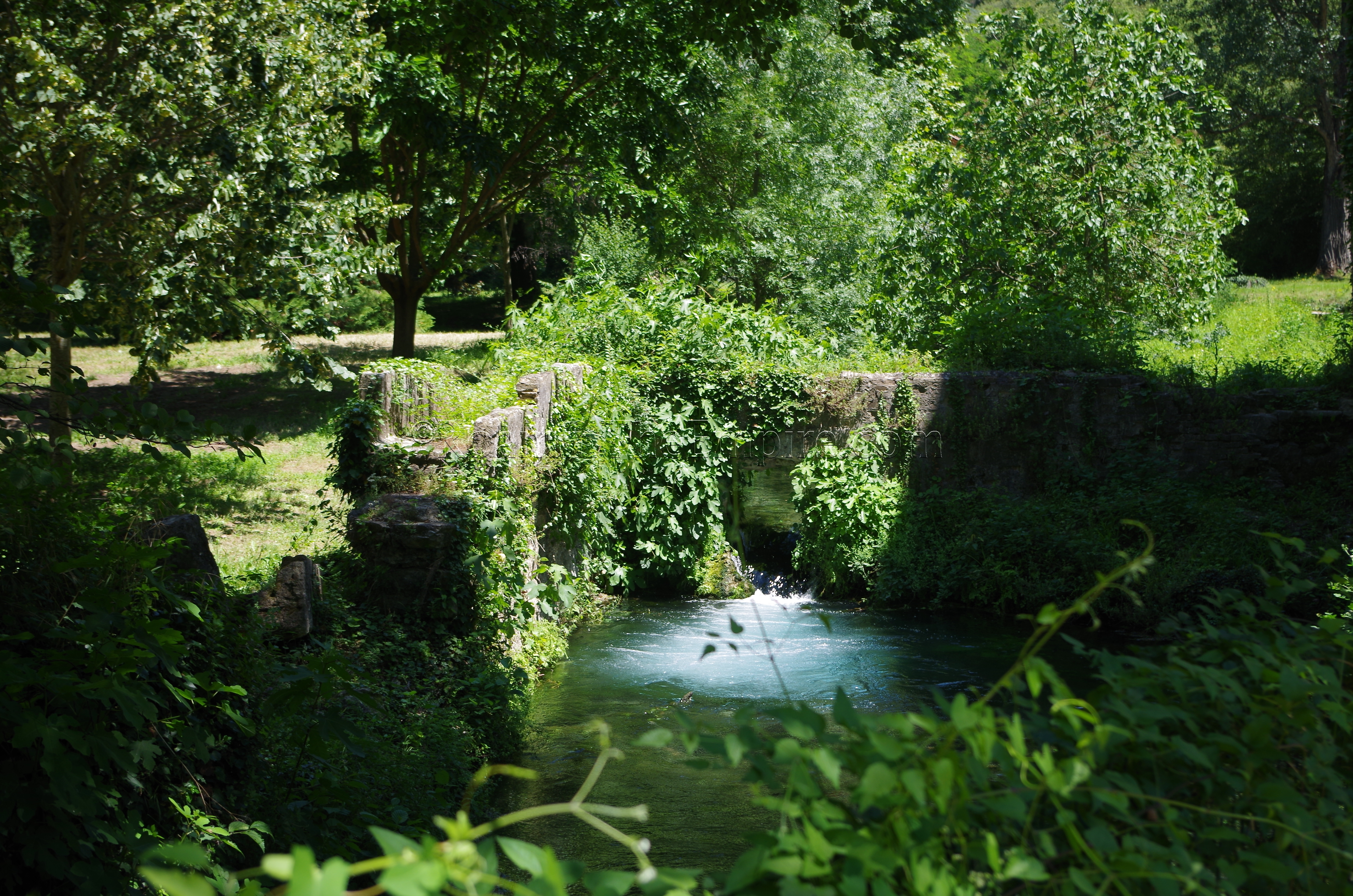
The source of the Nemausus aqueduct is the Fontaine d’Eure spring, located just to the east of the town of Uzès (Ucetia in antiquity), just a kilometer northeast of the city center. It’s certainly walkable from the city center, and there is a small parking lot nearby that is accessible from the D982 just outside of town. The actual point that serves as the source of the spring seems to be a matter of some debate. The primary source I considered places the source of the spring right next to the parking lot, where the modern pump house is located that makes contemporary use of the water supply. This is the location where a dedication to the nymphs of the spring was found. A construction about 600 meters to the south is sometimes identified as the source of the spring, but this seems to be a retaining basin for the aqueduct. It is this point that is possibly the actual starting point for the aqueduct as construction, though.
There are a few points between the Fontaine d’Eure spring and the Pont du Gard at which some small constructions from the aqueduct can be seen, but which I was not able to confirm. Some of the information I had was a little vague, and time constraints (I ended up spending more time than I planned at the Pont du Gard so that I could take the tour of the third level water channel) kept me from searching too diligently. Bornègre and Vers-Pont-du-Gard are apparently points at which these can be seen.

Pont du Gard
The Pont du Gard is only about a 20 minute drive from the Fontaine d’Eure. There is parking on both the left and right banks (the north and south side of the monument, respectively) of the Gardon River. The right bank parking is a little closer to the aqueduct bridge, but the left bank is the primary entrance point and is where the museum is located. Parking is ticketed, but it is included in the price of admission to the site. The Pont du Gard has varied opening hours over the course of the year, though the opening time is fixed at 9:00. It closes as early as 18:00 in the winter and as late as 23:00 at the peak of summer. It’s best to consult the website here for the exact opening times. Admission to the site is 9.50 Euro, though reduced evening tickets can be bought for 5 Euros in July and August. There is also an additional 6 Euro fee for a guided tour of the third level, in which you can walk through the water channel from one side to the other (well worth it) a few times a day, which are also posted on the hours of operation page.
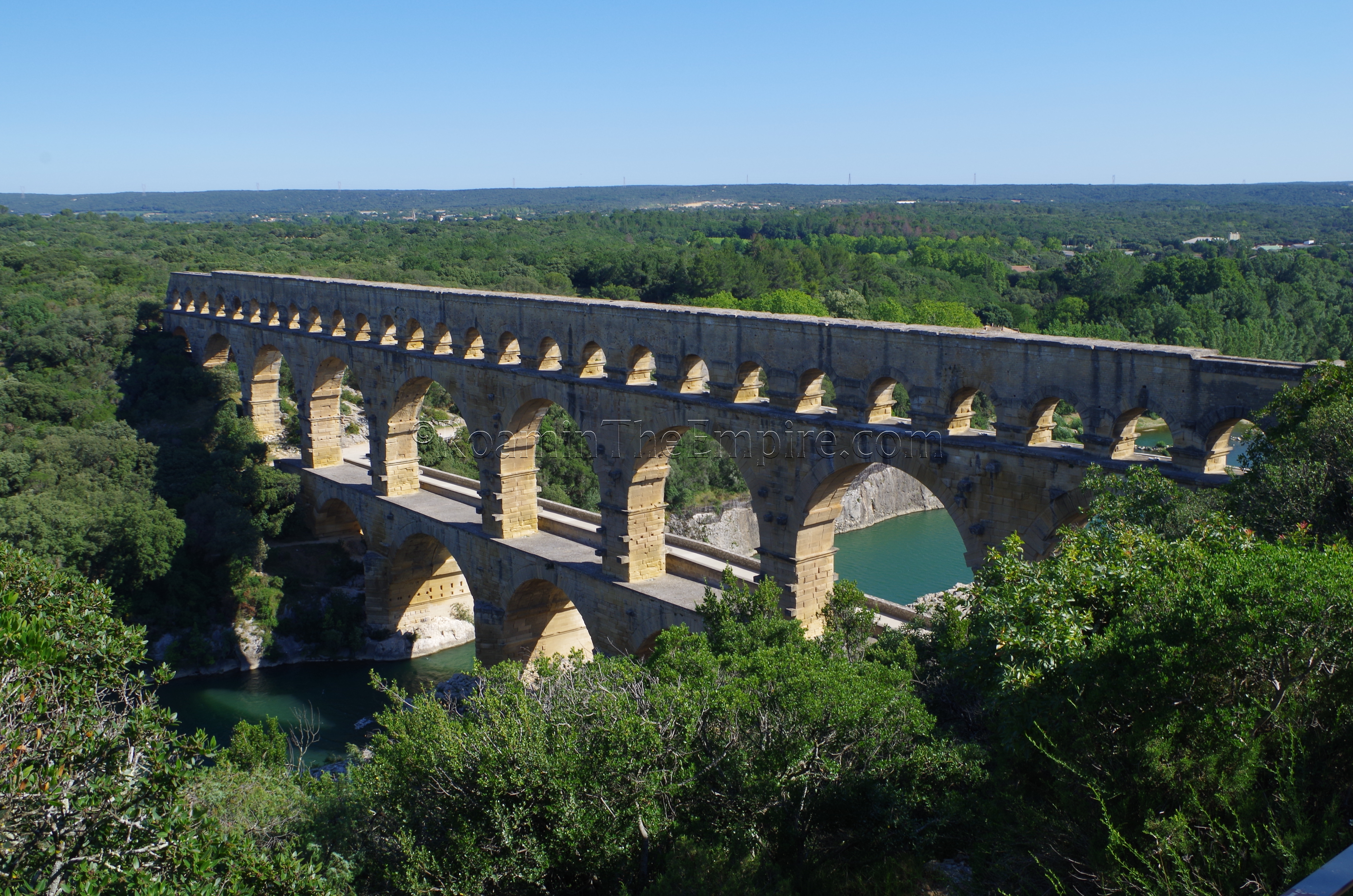
The Pont du Gard aqueduct bridge carried the Nemausus aqueduct for 360 meters (275 meters of which still remain) over the Gardon River at a height of nearly 49 meters. Three tiers of arches support the bridge, which was constructed without the use of mortar; except for the water channel, which was lined with it. The survival of the Pont du Gard owes in part to its use as a bridge over the Gardon in later periods. The road at the first tier was not originally part of the construction, but was a bridge added later, in the 18th century. Mason marks and graffiti from this construction and subsequent restorations of the bridge and aqueduct are plentiful and visible from the walkway.
The water channel of the aqueduct is generally closed off to the public, but a guided tour can be purchased that allows access and the ability to walk from the north side to the south side of the monument through the water channel. Not only is it interesting to be able to walk through the channel (some of which is still covered), but there are a few points where the channel wall is low and affords spectacular views of the surrounding area. It’s well worth the extra charge and possibly changing your schedule to fit the one of the few daily meeting times (which is what I ended up doing).
The on-site museum is more of information center than a museum. That is not to take away from it, as it is quite an interesting set up and explains a lot about this aqueduct specifically, as well as water usage and distribution in the Roman world in general. It is, however, largely devoid of artifacts, though there are some casts and reproductions of objects related to water and the aqueduct. It’s certainly worth the visit, particularly for the visitor that desires a little more context. Entrance is included with admission to the Pont du Gard and is open while the monument is open.
Pont du Gard Area
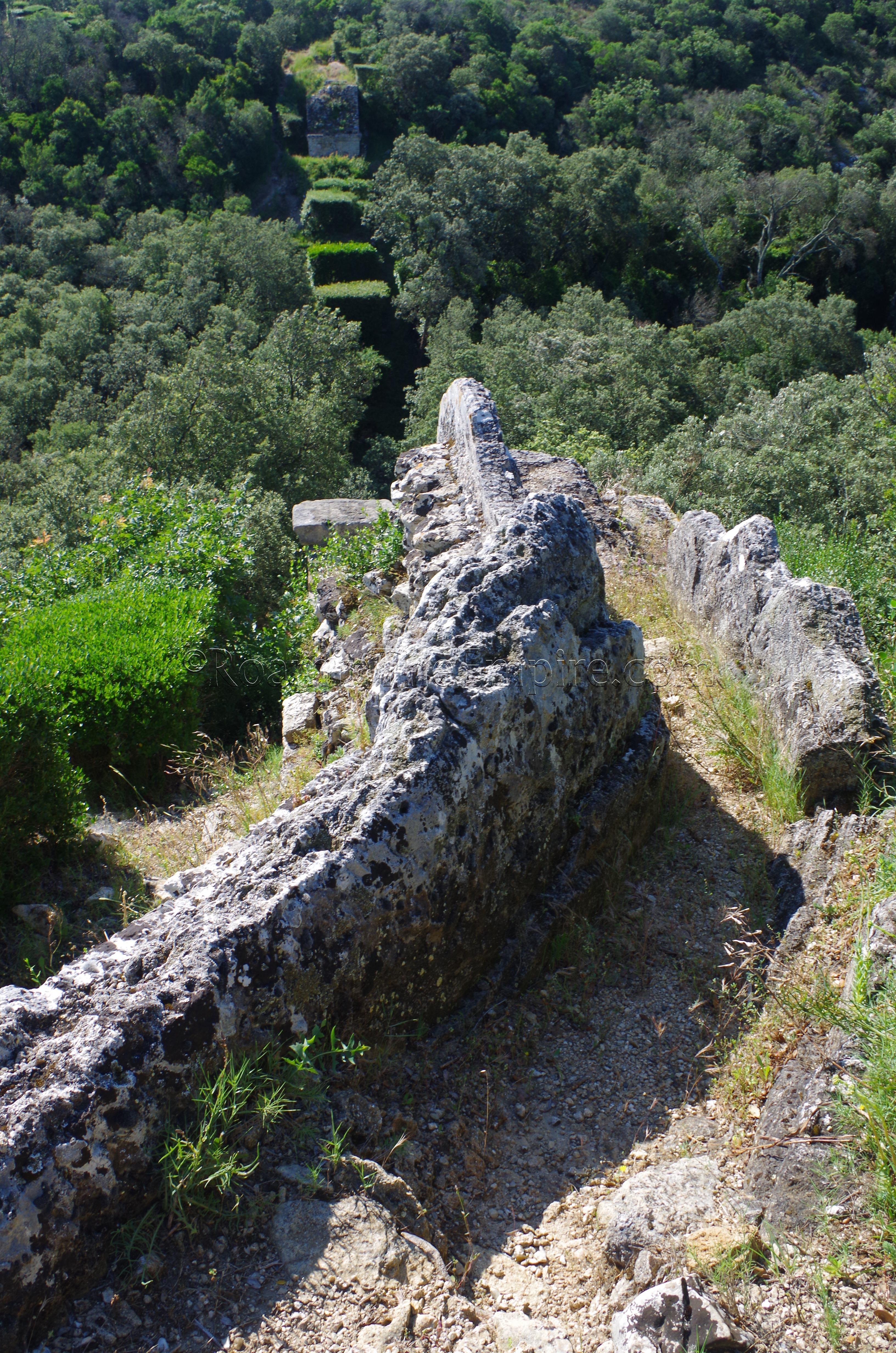
There are also some vestiges of the aqueduct in the immediate vicinity of the Pont du Gard. To the south of the bridge, the course of the aqueduct can be pretty clearly seen for a significant distance. The tunnel just to the south of the Pont du Gard is not Roman in origin, but rather a 19th century construction that served to channel water for transport across the aqueduct bridge during that period. The Roman water channel diverts off to the right of the tunnel and can be picked up again on the far side of the tunnel. The path of the channel, with significant remains can be followed a few minutes’ walk to the Pont de Valmale, a smaller bridge that spans a depression along the route. The arch has collapsed, leaving the center missing, and the piers are heavily reinforced to prevent further deterioration.
Past the Pont de Valmale, the aqueduct channel can continue to be followed along a path that runs adjacent (not the large path/road that the bridge effectively spans) to the channel leading out of the Pont de Valmale to the northeast. The remnants of the channel become scant in some places, but continuing along the trail and keeping aware of the smaller remains. Along the way, there is a nice view of the Pont du Gard. About a 10 minute walk from the Pont de Valmale, the trail ends in the northern abutment of the Pont de Combe Roussière. The Pont de Combe Roussière was a 25 meter bridge that spanned about 100 meters over a valley. Most of the bridge has since disappeared, except for the northern and southern abutments, of which the latter can be seen from the north side. There are a few more bridges that can be seen further south, but the Pont de Combe Roussière is where I stopped my hike southward.
Similarly, the aqueduct course may be followed through the park on the north side of the Pont du Gard as well. Following the path of the aqueduct channel leading north out of the Pont du Gard, the remnants are scarce, but distinctly present to start with. After a short walk, though, the remains of the aqueduct become quite prominent as the land raises and then drops, necessitating the channel to be built on a raised wall for a significant distance. This course of the aqueduct can easily be followed for about 700 meters, with some of the channel support being arched. Eventually this course of the aqueduct curves around and intersects with the D981. The course can be picked up on the north side of the D981 as the visible remains of the aqueduct continue on for quite a distance to the town of Vers-Pont-du-Gard.
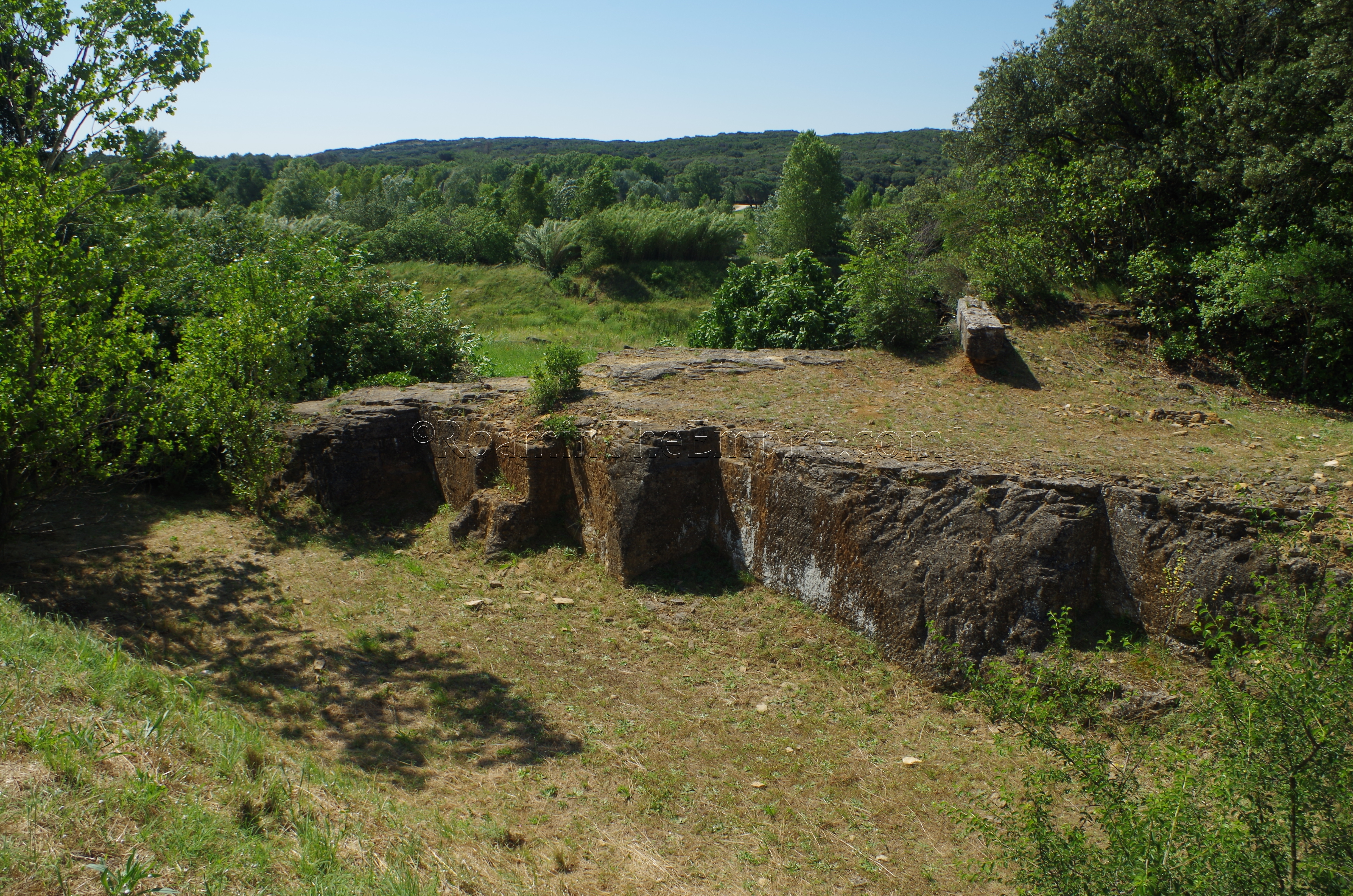
Just off the east side of the D981 as it approaches the left bank parking area are the remains of the Estel quarry. Though it is overgrown and mostly fenced off, there is a small path through some brush at which one can overlook some parts of the quarry. Located about 600 meters away from the Pont du Gard, this quarry was established for the construction of the Pont du Gard and the aqueduct structures adjacent to it. It is estimated that about 120,000 cubic meters of stone were quarried here (about 21,000 cubic meters of it used on the Pont du Gard) until it fell into disuse following completion of the aqueduct.
Sernhac Tunnels
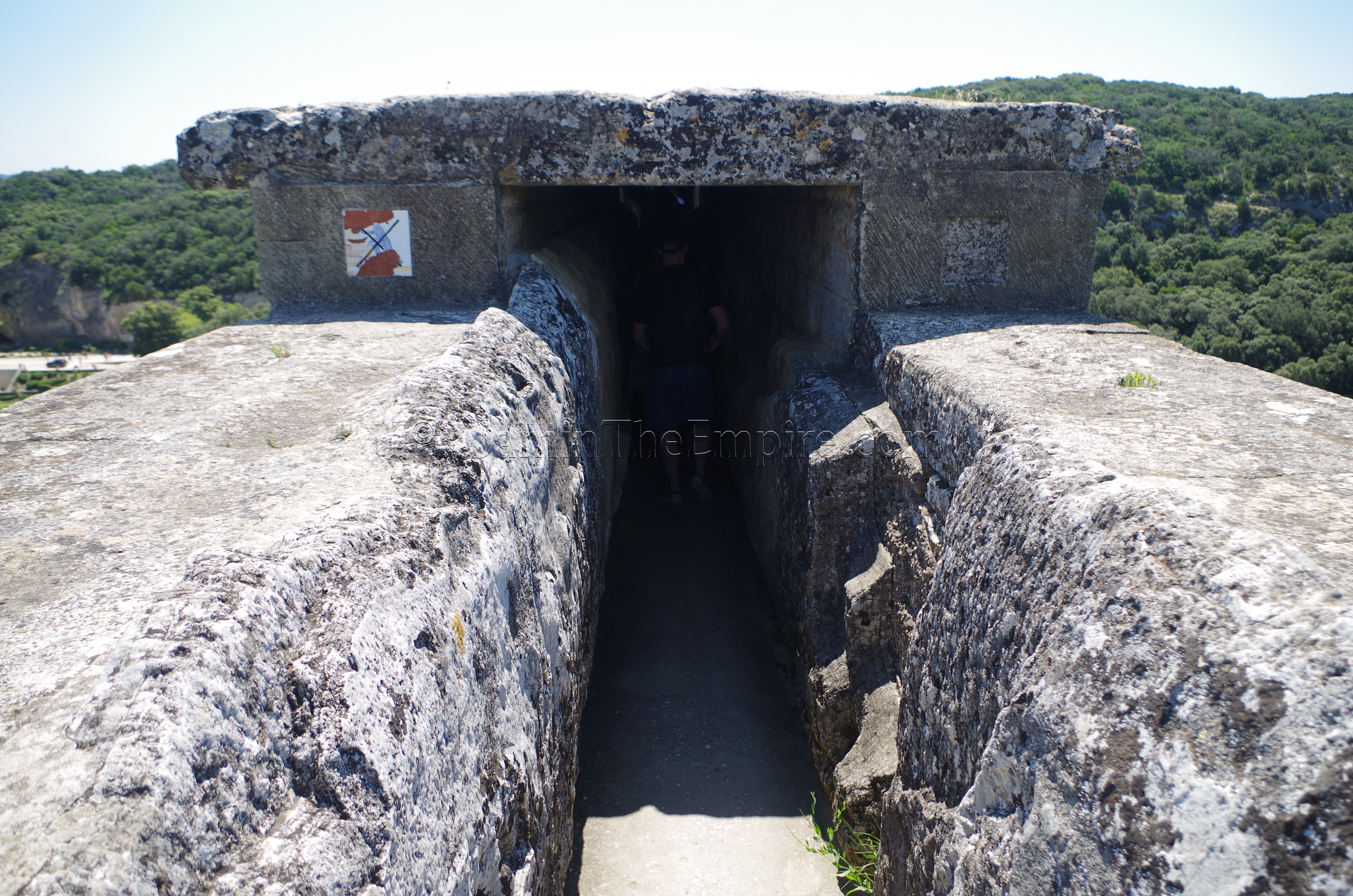
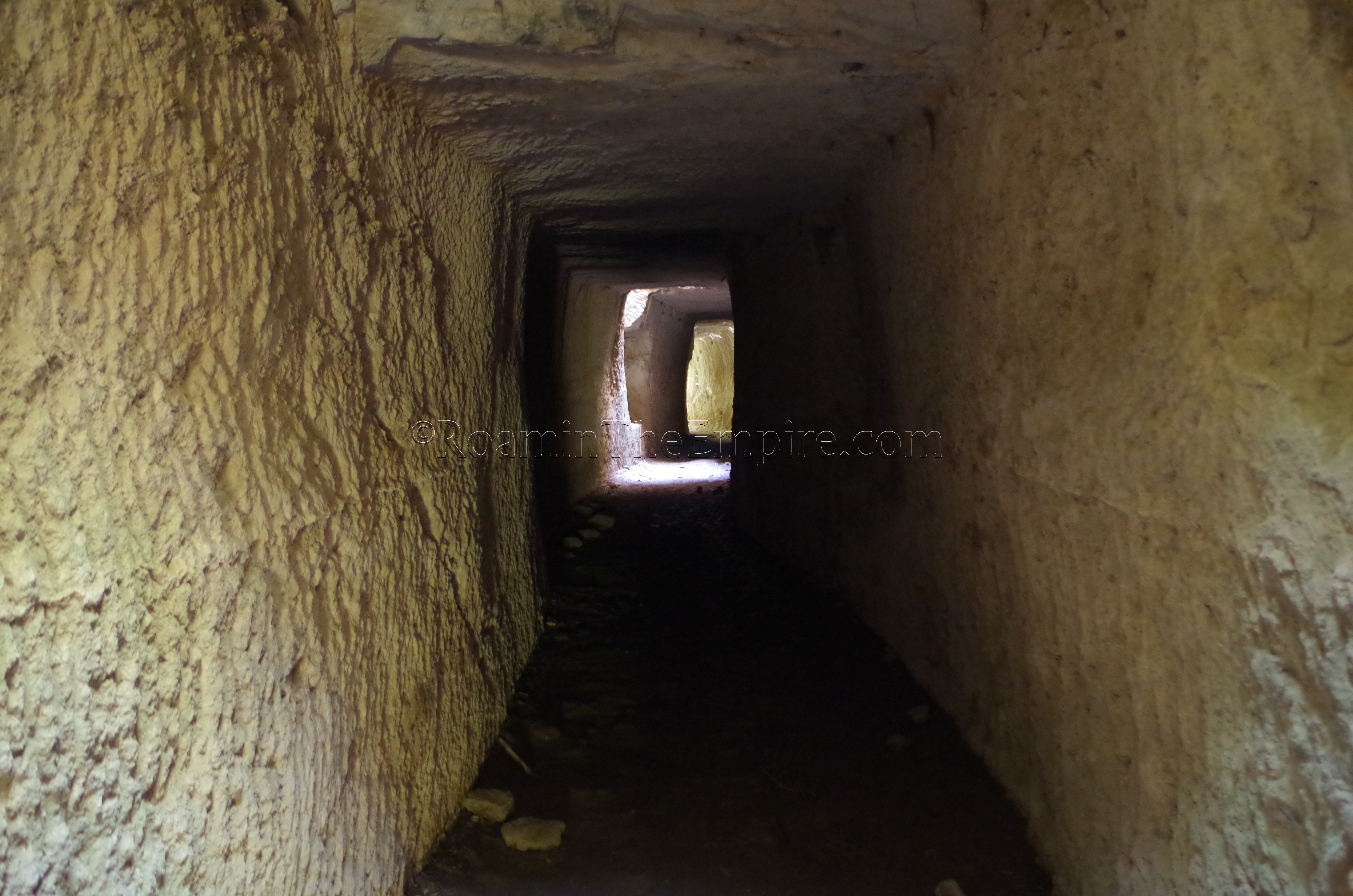
The last stop I visited along the course of the aqueduct was the tunnels near Sernhac, south of the Pont du Gard. There is some signage from town leading to the tunnels, but it is not consistent or easy to find. Fortunately, the aptly named Chemin de l’Aqueduc leads to the parking area. There is a small dirt parking lot, and the tunnels are located just to the northwest and southwest of the parking lot. Both tunnels are large enough to walk into and through. The north tunnel, called La Perrotte, stretches 66 meters, and the south tunnel, called Les Cantarelles, stretches for 60 meters. Both tunnels also have putei, shafts sunk down from the surface to the channel and have cuts in the rock for the channel leading into and out of the tunnels. The area was already a quarry prior to the construction of the tunnel, and there is evidence of this in the rock adjacent to the tunnels. It was also evidently a quarry in later periods, which has apparently damaged the tunnels in some capacity as well.
The terminus of the aqueduct in Nemausus (Nîmes) is also visible in the form of the castellum aquae, addressed in the post on that settlement. The whole of the route is easily doable in a single day, and with the right time management, even the remains that I was not able to visit can probably be found and seen. The Nemausus aqueduct is relatively unique in that both the start and finish are preserved and easily accessible, and so much of the route can be seen as well. Particularly in that areas of both a grand aqueduct bridge and subterranean tunnels can be seen, allowing the visitor to see the primary elements that would have made up Roman aqueducts.


Sources:
Bromwich, James. The Roman Remains of Southern France: A Guidebook. London: Routledge, 1996.
King, Anthony. Roman Gaul and Germany. University of California Press, 1990.
Ortloff, Charles. “The Pont du Garde Aqueduct and Nemausus (Nimes) Castellum: Insight into Roman Hydraulic Engineering Practice.” Journal of Archaeological Science, Vol.20, 2018, pp. 808-817.