


Most Recent Visit: June 2018.
Valentia
In antiquity, the French city of Valence was preceded by the Roman settlement of Valentia. Valentia was located at the second most important crossroads in the region, behind Lugdunum, where the Via Agrippa running between Lugdunum and Arelate intersected with a road running to the east toward Italy via the Drôme Valley. The settlement was in the territory of the Segovellauni tribe, and seems to have received a colony under either Caesar or Augustus. The history of settlement prior to that, though, is unclear, and it may have developed from a Roman military camp, rather than a Gallic settlement. Further, Valentia does not seem to have featured much in the history of the Roman period.
The remains from Roman Valentia are also fairly scant, with no major vestiges of the Roman settlement being visible. There is, however, a large art and archaeology museum with a sizable collection of Roman artifacts in the city. During the construction of this museum, some remains of the odeon of the ancient city were found and the position of this odeon is reflected in the flooring of the museum near the entrance.
The Musée de Valence is located in the historic center of the city at 4 Rue Saint-Didier. It is open Tuesday to Friday from 10:00 to 12:00 and From 14:00 to 18:00. On the third Thursday of the month, it is open until 21:00. The museum is closed on Mondays and Tuesdays. Admission is 6.00 Euro.
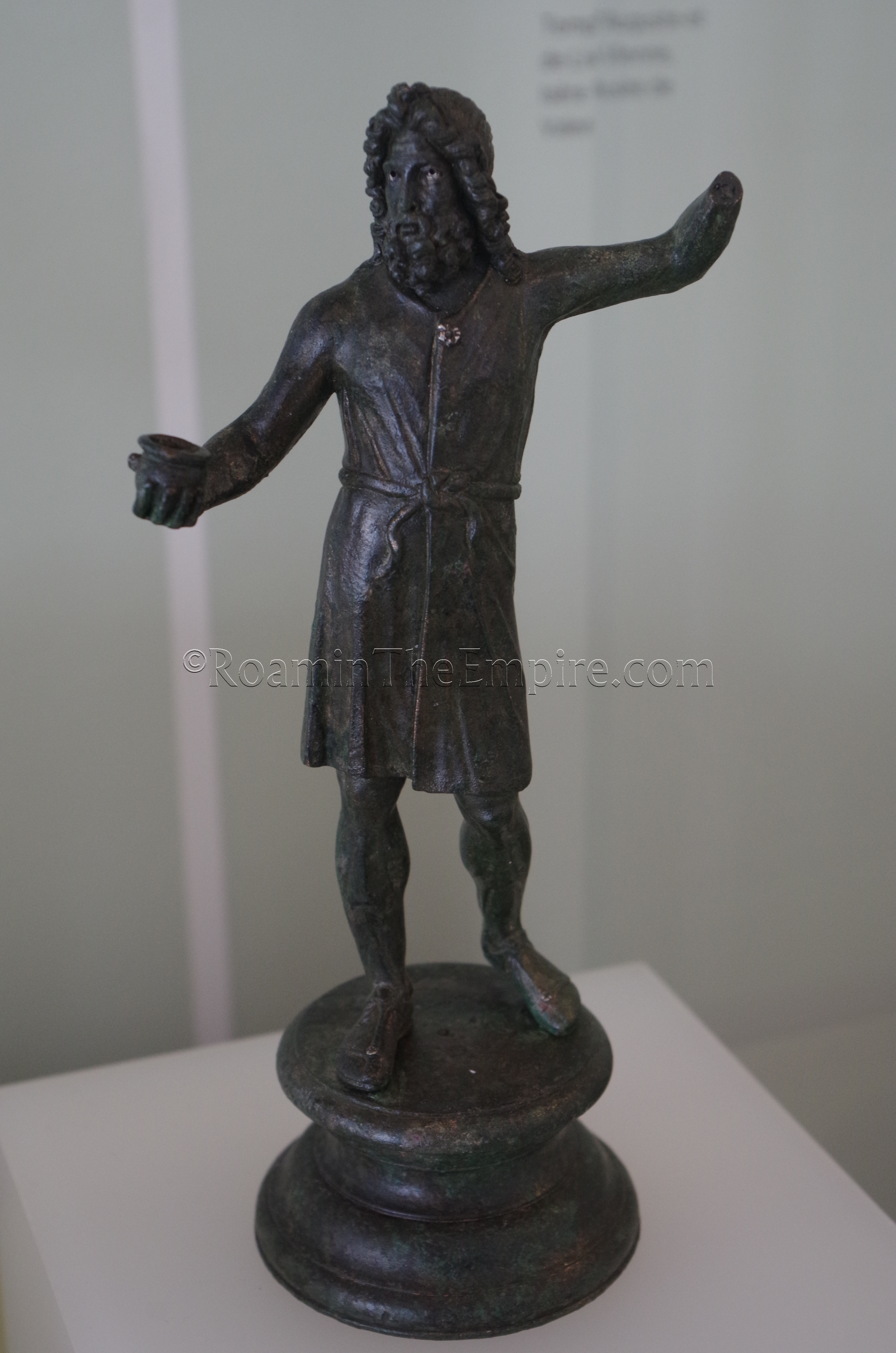
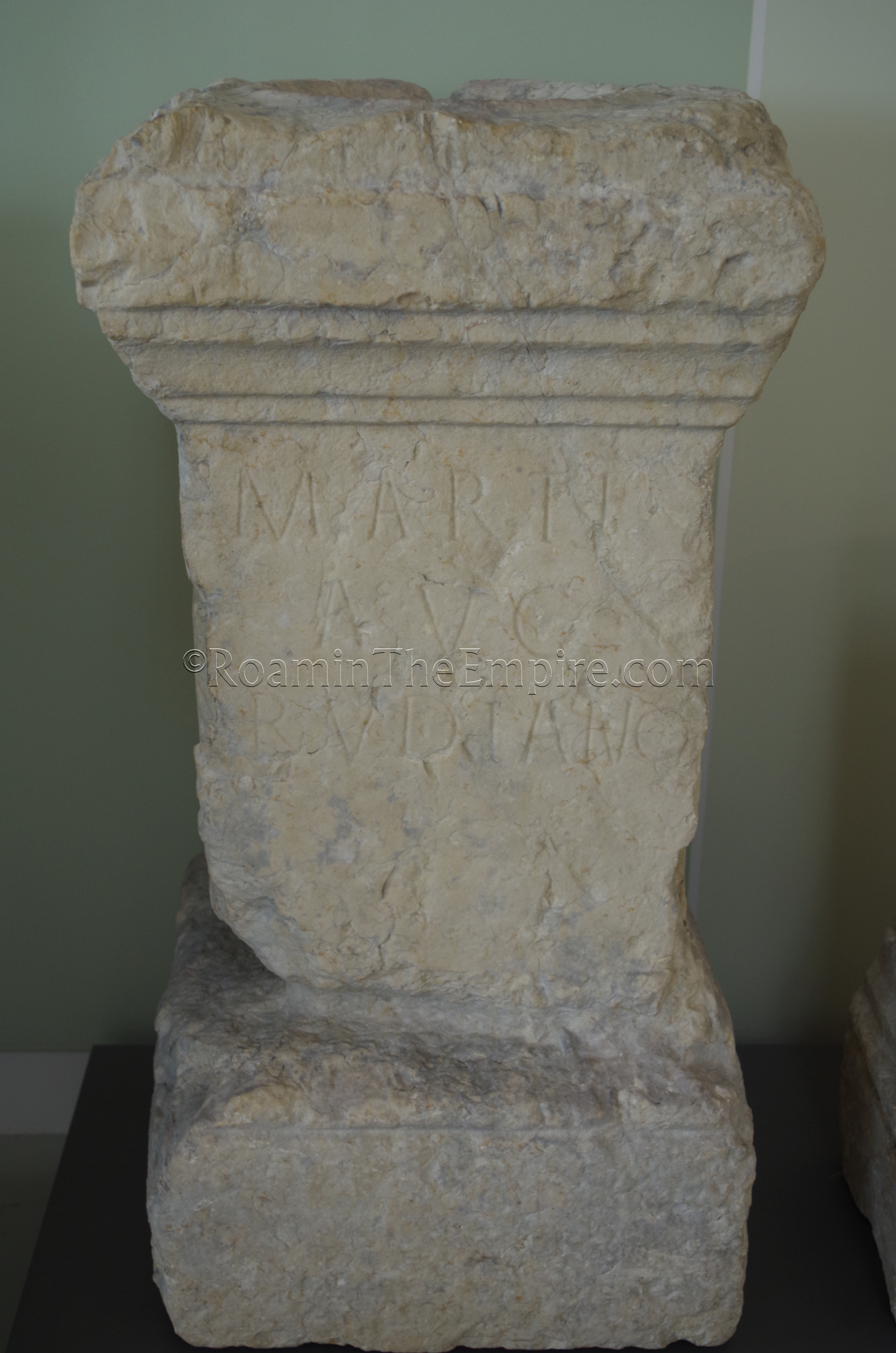
The collection at the Musée de Valence is not purely archaeological, there is a large art collection housed in the museum, but there is a significant amount of space devoted to archaeological artifacts, many of them coming from finds within the city. A fair amount of the archaeological finds consist of the typical objects found in similar museums; small bronze statuettes, funerary inscriptions, ceramics, small household objects, and statuary fragments. There are some nicer alters and artifacts relating to Gallo-Roman religion as well, and additionally some dedicatory and honorific inscriptions not related to funerary practices or religion.
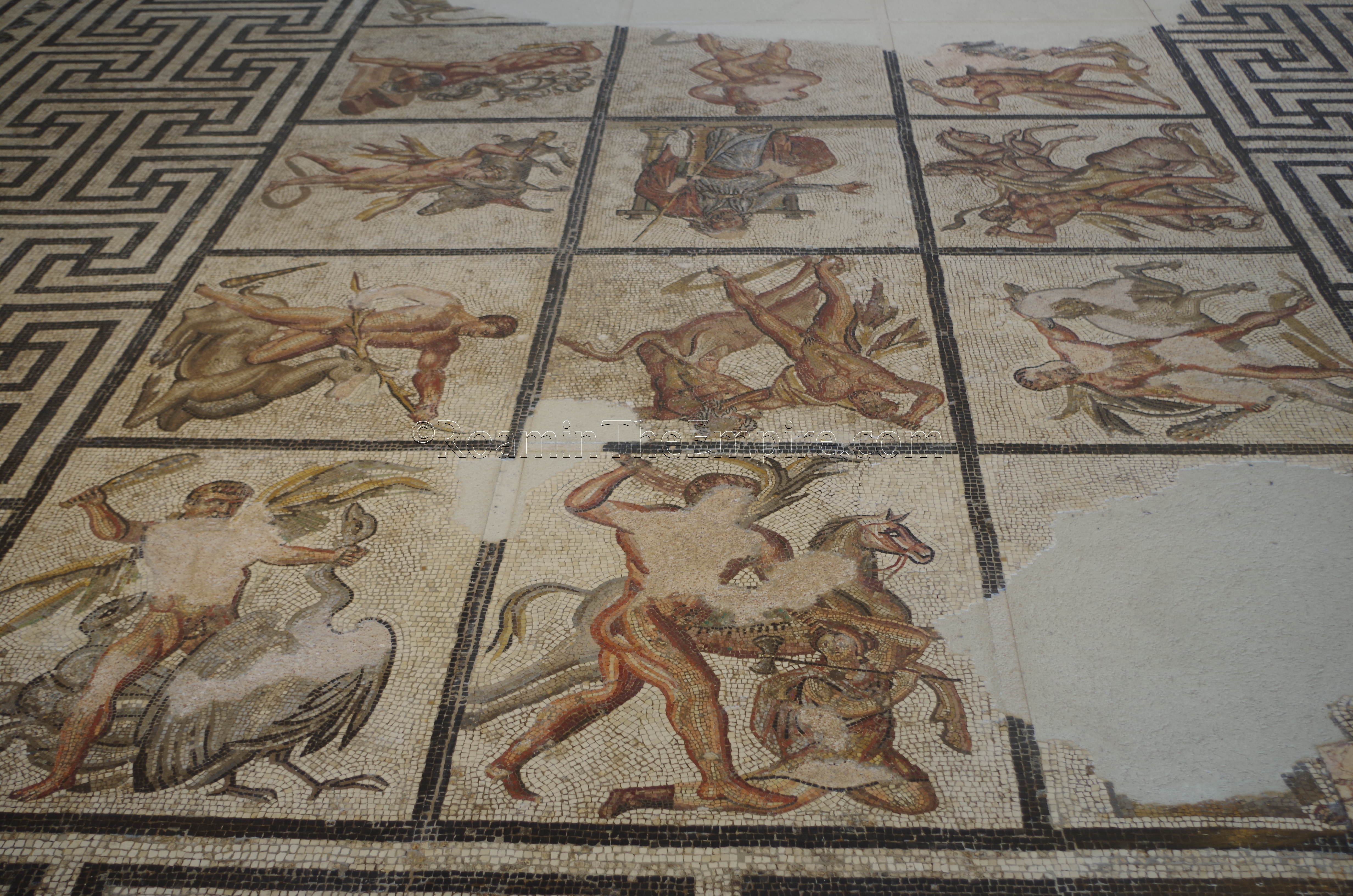
The biggest draw for the museum, though, are the mosaics. In addition to a number of smaller or geometric mosaics (including one ‘inscribed’ with the name of its creator), there are two large figural mosaics; one depicting Orpheus and the animals, and the other depicting the 12 labors of Hercules. The level of completion of the mosaics is pretty impressive, though both have significant portions missing. Perhaps the one drawback is that the angles of viewing for the mosaics are not the greatest. There are elevated areas near the mosaic room, but, they are not optimally used to give better overall views of both the mosaics; rather, they must primarily be viewed from ground level, which doesn’t do quite as much justice to them given their size. There is a little bit of an overview for the Orpheus mosaic, though. Regardless, they are quite impressive and one of the main reasons I made the stop at the museum.
The mosaics really do make the stop at the museum worthwhile, even given the less than ideal presentation. The museum as a whole is quite nicely put together and has a very modern feel. There are informational signs with most objects, though, as one might expect, they are almost exclusively in French. It took me not quite an hour to get through the archaeological collection of the museum, and perhaps a little longer to see some of the other art in the museum.
Valentia is a relatively significant city in the region, and as such, it is well connected to other cities in the area by rail and bus connection. The train station is less than a 10 minute walk away from the museum. I had a vehicle, and navigation to the museum is fairly easy. There is a large underground parking structure just a few blocks away at Esplanade du Champ de Mars, which makes visiting even with a person vehicle pretty easy.
Le Pouzin Bridge
Between Valentia and Arausio about 90 kilometers to the south, roughly along the route of the Via Agrippa, which ran along the east side of the Rhône, there are two remaining Roman bridges that span tributaries emptying from the west into the Rhône. Though they are both on the wrong bank of the Rhône to have served the main route of the Via Agrippa, they were probably associated with the parallel road on the west bank. This stretch of territory along the Rhône also roughly corresponded to the eastern edge of the territory of the Helvii, discussed in the previous post on Alba Augusta Helviorum.
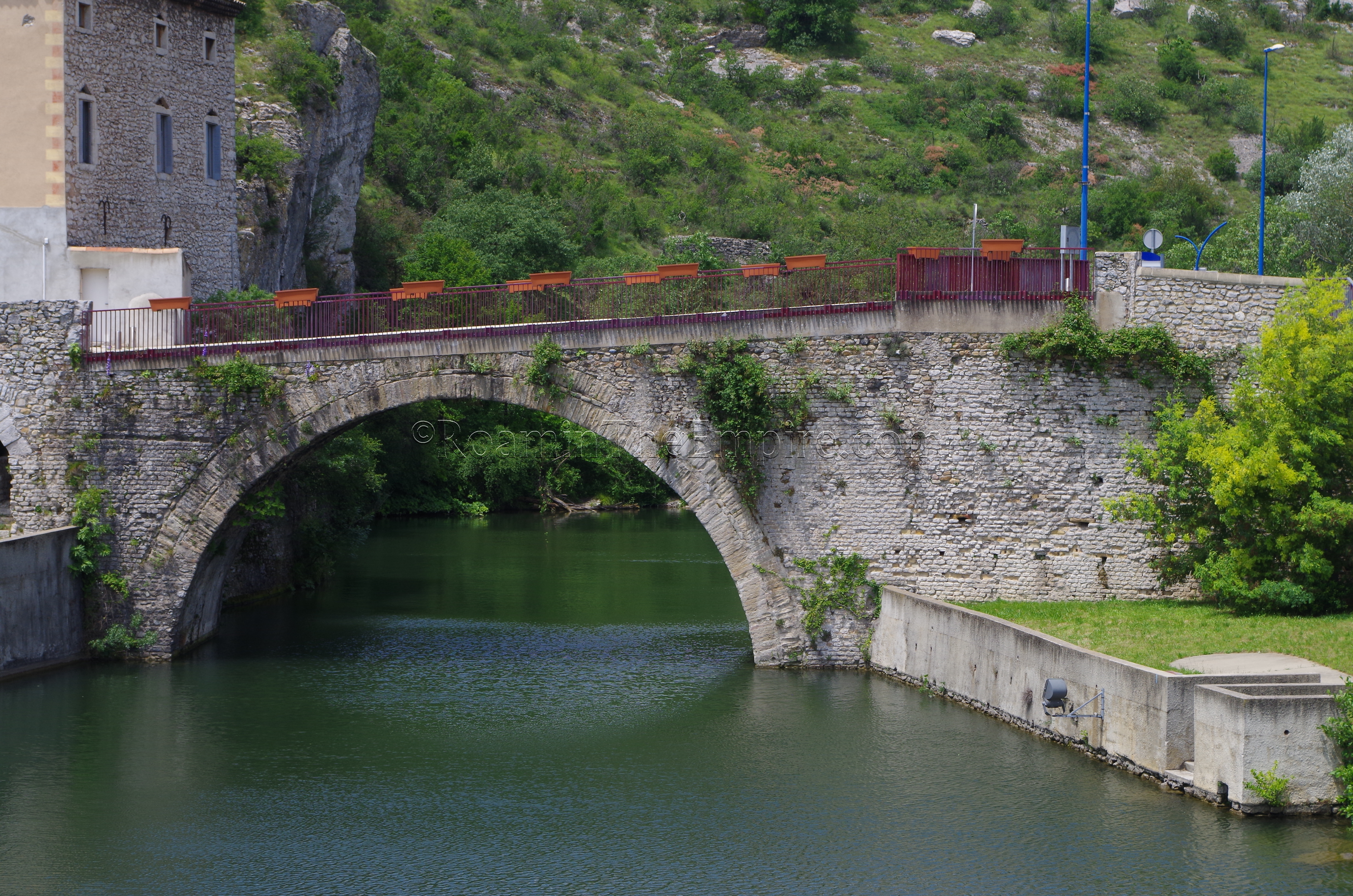
The first of these two bridges is located in the small town of Le Pouzin, about 30 kilometers southwest of Valence, and bridges the Ouvèze River. There does not seem to be much information about a Roman settlement at the location, though it wouldn’t be unheard of for some kind of settlement to spring up around a river bridging. The bridge, though, seems to be the only remaining standing archaeological vestiges of Roman presence in the immediate area (though artifacts have been found in the vicinity). Repairs from the post-Roman eras of the bridge’s use are evident, but the lower portions of the bridge best preserve the Roman constructions. The foundation piers of the bridge exhibited the most evident Roman work, but the level of the Ouvèze is higher than in the Roman period, and the piers are now submerged. The second arch on the west side of the river does not appear to be of Roman construction. The bridge is open to pedestrian traffic.
Getting to Le Pouzin from Valence is possible via the TGV bus line 73 that runs from Valence to Aubenas. The bus leaves from a few stops in Valence, including the main train station, and takes about 40 minutes to get to Le Pouzin, dropping off just a few minutes from the bridge. There are several stops daily, but the schedule varies depending on the day; the schedule can be found here. Driving is perhaps the more convenient option, and there is small parking lot about 100 meters south/southeast of the bridge off Avenue Marcel Nicolas.
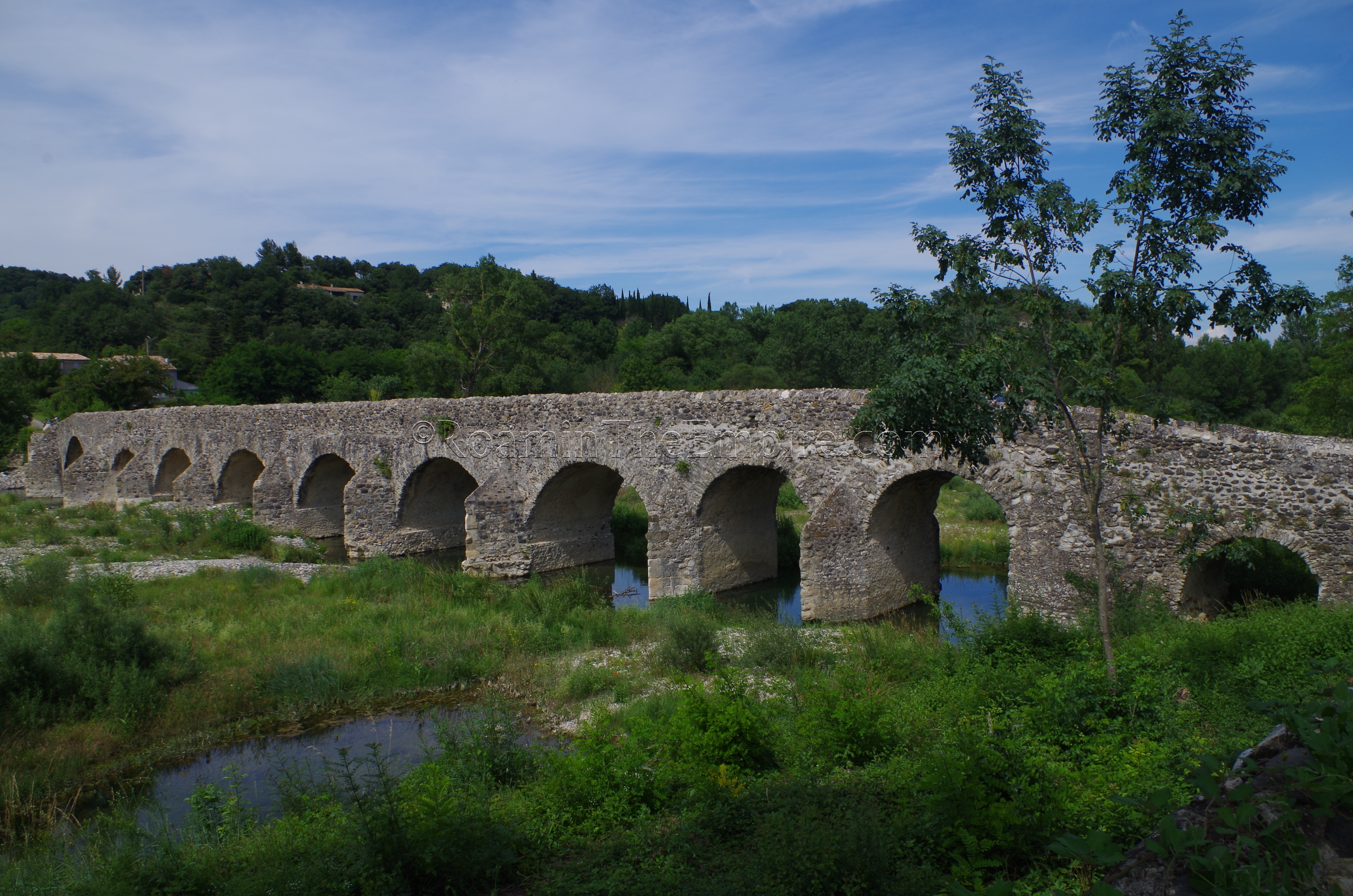
Viviers Bridge
Further south, on the northwest outskirts of Viviers is the second of the two bridges. This bridge, which spans the Escoutay River, is much longer than that at Le Pouzin, measuring about 100 meters in length and consisting of 11 arches, though it is theorized it may have originally consisted of 12 or 13 arches. Some of the existing arches seem to be reconstructed to some degree, though piers mostly appear to be of Roman construction. Like the Le Pouzin bridge, the bridge at Viviers is closed to auto traffic, but is still used by pedestrians.
From Montélimar, the nearest city with a train station, there is a bus line that runs through Viviers. The line 20 bus runs from the Montélimar train station to Pont St. Esprit, with a few stops in Viviers. The most practical stop in Viviers would probably be the La Poste stop, which in turn is about a 1.5 kilometer walk to the bridge. The bus runs to and from Viviers several times a day and the schedule can be found here. The area of the bridge is not very busy, and there is some on-street parking near the bridge if taking a private vehicle.
Bourg-Saint-Andéol Mithraic Relief
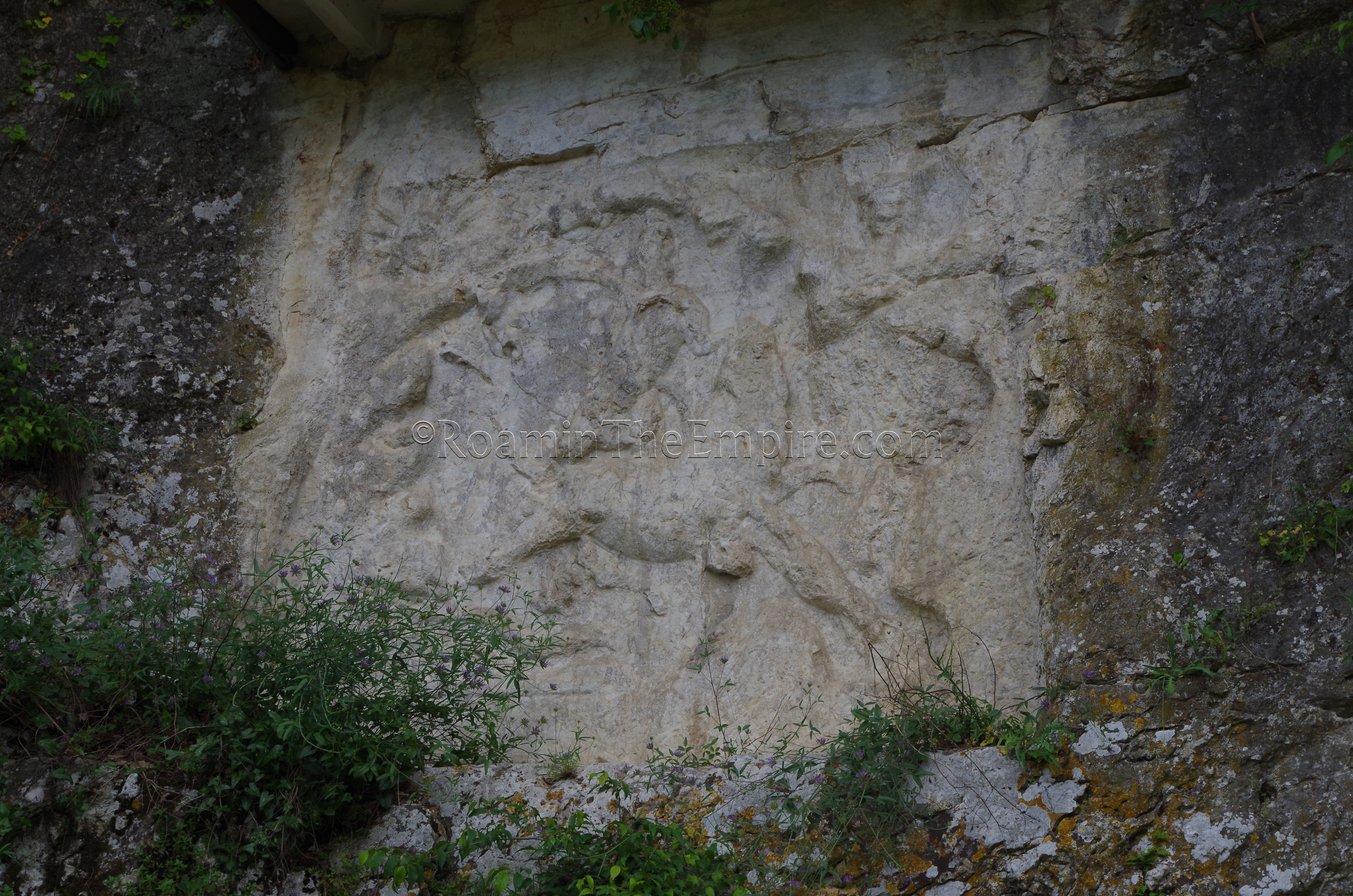
At the southern end of the Helvii territory along the Rhône is the modern town of Bourg-Saint-Andéol. In antiquity the settlement here was called Bergoiata, a name that seems to have originated during with the Gallic-era town here. Not much is known about the history of the settlement, as it seems to have been a relatively minor stop along the Via Agrippa. The modern name, however, does derive from the martyrdom of Saint Andeolus at Bergoiata by Septimius Severus in 208 CE. Other than that, bit, the settlement doesn’t feature at all in the historical record, and little remains of the Roman era settlement. What does remain though, is quite unique; a Mithraic tauroctony bas-relief carved into the living stone of a cliff face.
Located just a few minutes’ walk from the center of town, the relief is located in a park along the Ruisseau de Sardagne stream, which empties into the Rhône less than a kilometer upstream from the relief. The relief, the only known Mithraic tauroctony carved into living stone in all of France, sits about 2 meters above ground level on the cliff face on the west side of the park. Though now protected somewhat from the elements by a small awning installed over it, centuries of weathering and human interference have certainly taken their toll on the relief, and many of the details are unrecognizable. The general form of the formulaic tauroctony scene is pretty recognizable, even with all the damage. So too are the rays of Sol’s crown in the upper left hand corner of the relief. Luna too was featured in the carving, but her presence in the upper right hand corner of the relief is much harder to make out. On the lower left hand corner is a dedicatory inscription, apparently very difficult to read under the best of circumstances, but inconveniently covered by unkempt foliage when I visited. The inscription notes the dedication of the relief, perhaps by a numen of the Augustales named Titus Aurelius or by Greek traders, according to different interpretations of the inscription.
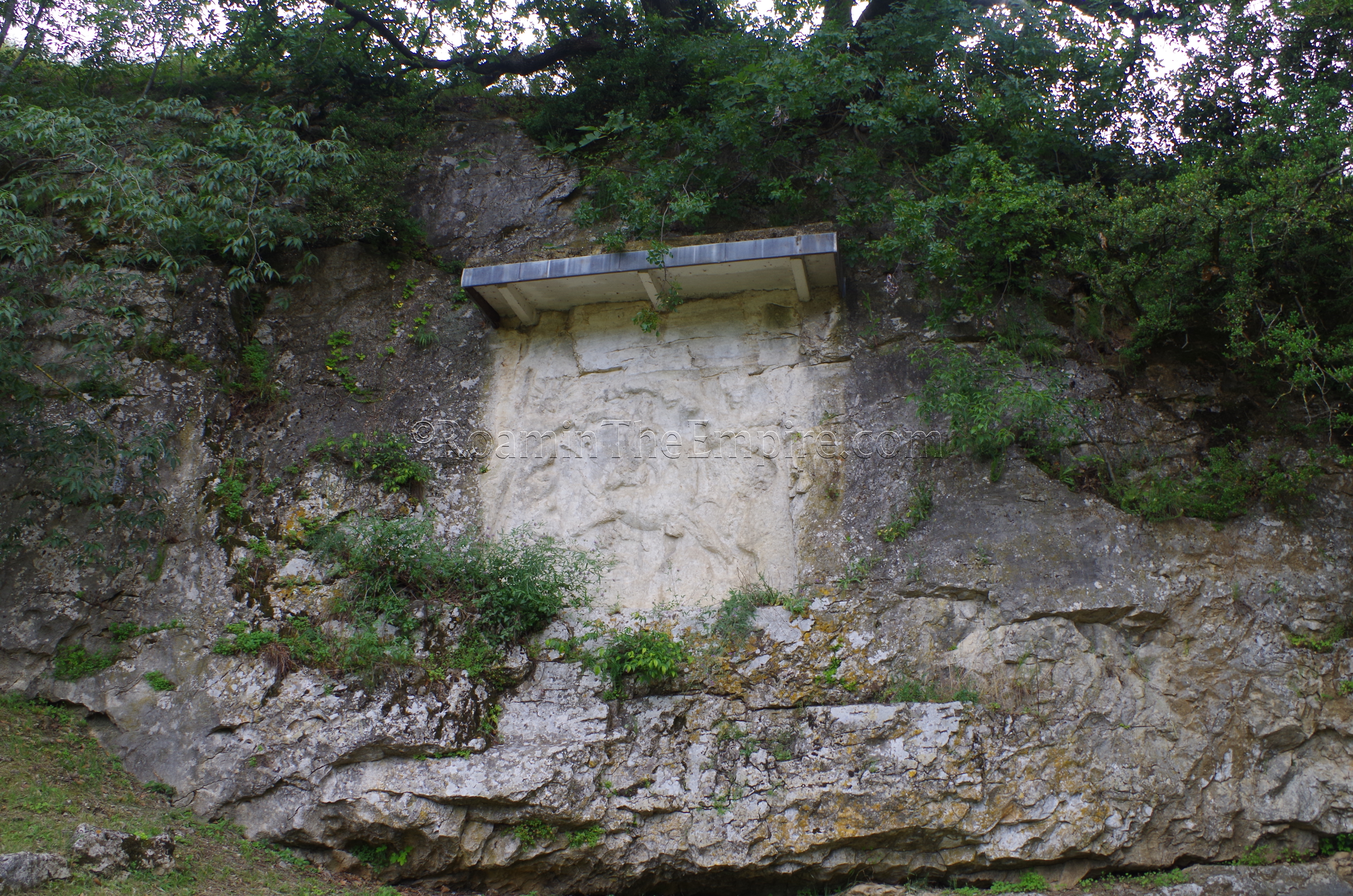
The relief was part of a larger temple complex, probably set in a cave that is no longer extant. The relief itself seems to have been in danger of being destroyed in the late 19th century during the construction of the rail line that runs above it, and which may have contributed to the loss of the cave as well. The carving of the relief into living rock would have had particular meaning to the cult, as the Mithraic tradition included the petrogenesis (birth from rock) of the god. The dating for the relief doesn’t seem to be very secure, but is generally regarded as being from the 3rd century CE. A small informational plaque (in French) explains a little about the relief and features an illustration of the relief in a better state of preservation.
While a train tracks run right above the park in which the relief is located, there is no train station in Bourg-Saint-Andéol. The closest train station is a few kilometers away, across the Rhône in Pierrelatte. The two towns are not especially well connected by public transport, but there is a bus, Le Sept Line 29, which runs a few times a day between the two towns, and the schedule can be found here. Using a private vehicle is really the most efficient way to visit the relief at Bourg-Saint-Andéol. There is a suitable public parking lot (with one hour of free parking) located at Place du Champ de Mars, which is also where the tourist office is. From there, it’s less than a half a kilometer’s walk south along Avenue Marc Pardelle to the park with the relief.


Sources:
Blanc, André. “Ponts Gallo-Romains et Trés Anciens de L’Ardéche et de la Drôme.” Gallia, Vol. 24, No. 1, 1966, pp. 77-99.
Bromwich, James. The Roman Remains of Southern France: A Guidebook. London: Routledge, 1996.
Stillwell, Richard, William L. MacDonald, and Marian Holland. McAllister. The Princeton Encyclopedia of Classical Sites. Princeton, NJ: Princeton U Press, 1976.