


Tibula
The exact location of the city of Tibula, the northern terminus of the Tibula Sulcis road, is a matter of some debate. The generally accepted area is somewhere along the north coast of Sardinia. One theorized location is in the vicinity of present-day Castelsardo, just up the coast from Turris Libysonis. The other most theorized location is on the Errebantium Promontorium, near the modern town of Santa Teresa Gallura at the northernmost point of the Sardinian mainland. Ptolomy’s work seems to put Tibula at the location near Castelsardo, closer to Turris Libysonis than Errebantium Promontorium. He does note, though, that the Tibulati people, inhabit the northernmost area of the island. If Tibula indeed derives its name from the Tibulati, the location would more logically correspond to the Errebantium Promontorium location.
The modern consensus seems to favor Tibula’s location as being on the Errebantium Promontorium, as well, despite the placement by Ptolomy. The Antonine Itinerary would also seem to favor the more northern location as well. The itinerary notes four roads originating/terminating in Tibula. Unfortunately, neither the proposed location at Castelsardo nor the location at Santa Teresa Gallura have revealed significant archaeological finds that would prove either way which location was indeed the spot of Tibula in antiquity. Though there aren’t archaeological remains of Tibula itself at Santa Teresa Gallura, the vicinity of the settlement offers some interesting stops nonetheless.
The nearby Capo Testa promontory was a significant quarrying source for granite in the Roman period. The specific variety of granite in the region is known by several names including Rosa Gallura, Gallura Granite, Rosa Beta, or Sardinian pink granite. It is believed that granite quarried at Capo Testa was even used for the construction of monuments in Rome itself. The first century CE seems to have been the height of use of these quarries. Two of the columns re-used in the Basilica di San Clemente in Rome are apparently sourced from the Capo Testa quarries. There is some suggestions that elements of the Pantheon are also constructed from Capo Testa granite. Quarrying continued at Capo Testa through the medieval period, with stone used in Pisa’s cathedral and tower also being sourced from Capo Testa in the 12th century CE.
Getting There: Santa Teresa Gallura does not have a train station, and as such, other than a personal vehicle, the main way to get there from elsewhere on the island is by bus. There is a bus that runs from the center of Olbia to Santa Teresa Gallura and back a few times a day. The bus line is 601 and the schedule can be found here. The price is 4.30 Euro each way and the trip runs between 2 and 2.5 hours each direction. There is also ferry service between Santa Teresa Gallura and Bonifacio, Corsica. From Santa Teresa Gallura, it’s about a 4 kilometer walk to the area of interest, Capo Testa. Alternatively, Capo Testa is popular for beachgoers, and in the summer there are buses that run several times a day from Santa Teresa Gallura. The schedule for that bus can be found here. The price is 3.50 Euro for a round trip.
Though no actual remains of Tibula have been found, several points of interest can be found on the nearby Capo Testa. It is worth noting that the promontory (and this area of the coast in general) is a very popular beach location during the summer. As such, arriving from mid-morning on can be troublesome both in terms of traffic and parking, should one arrive with a private vehicle. Since I drove from Olbia, which was over an hour away (getting stuck behind a truck is a real possibility), I got there around 8:30 and there was plenty of parking available near Spiaggia Zia Culumba and not a whole lot of people there yet. That changed drastically through the day, though. Since parking can be an issue, I found a parking spot when I first got there and just walked the rest of the time to avoid having to bother with parking.
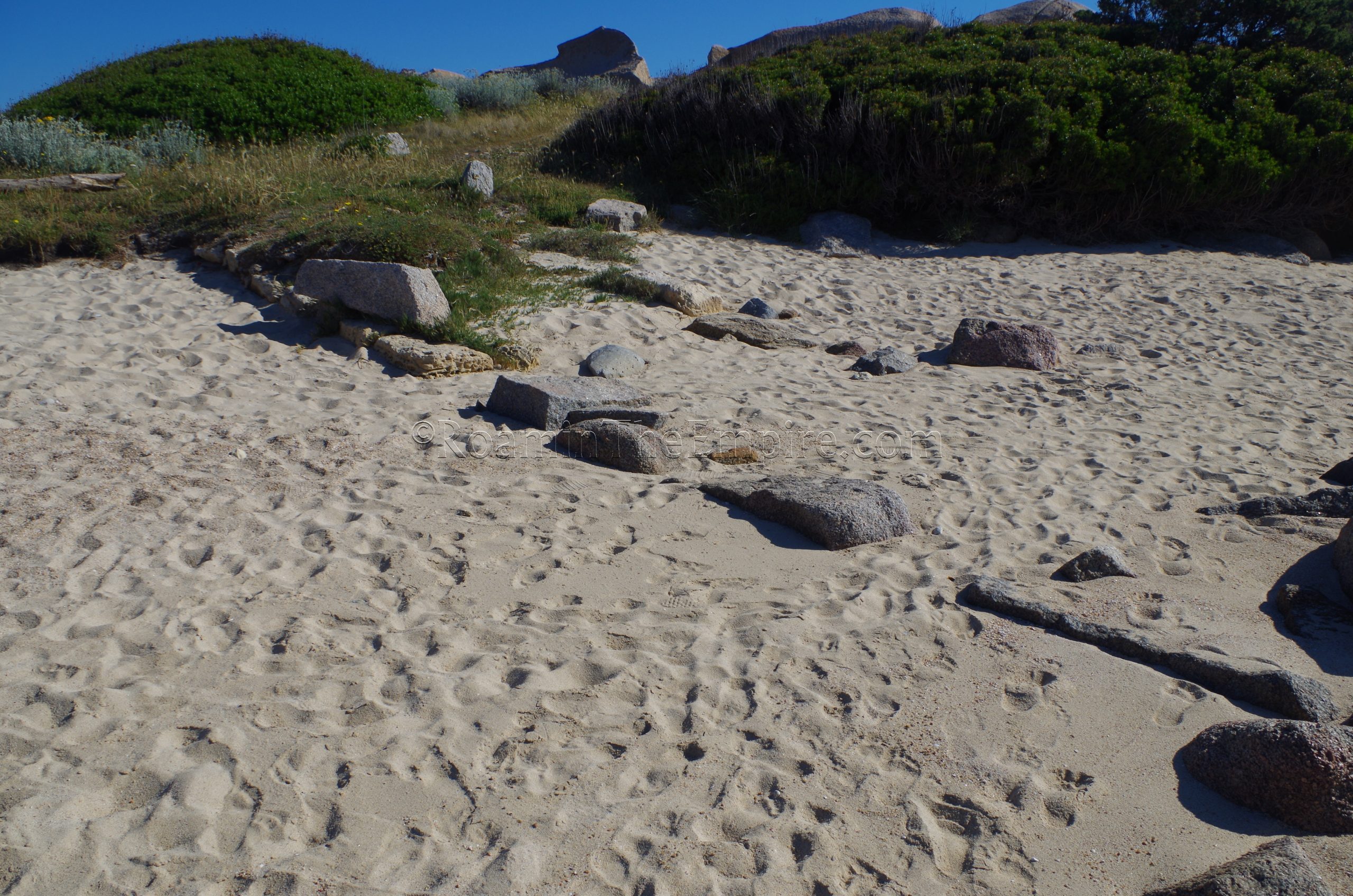
At the start of the narrow bridge of land that connects Capo Testa with the rest of Sardinia, there was apparently a necropolis in the Roman age. This area is bounded by the Rena di Ponente beach and the Via Capotest. Unfortunately, I couldn’t find any remains of any Roman funerary activity in the area. There also is apparently the remains of a Roman tomb along the very southeastern corner of Capo Testa, at the location of the Scogliera della Funtanaccia. Again, I couldn’t find anything in the way of a Roman funerary monument or any evidence of activity. Granted, aside from the trail that led down to the water, the area was pretty heavily covered in undergrowth, so anything that wasn’t of significant size could pretty easily be overlooked.
Valle della Luna Quarry
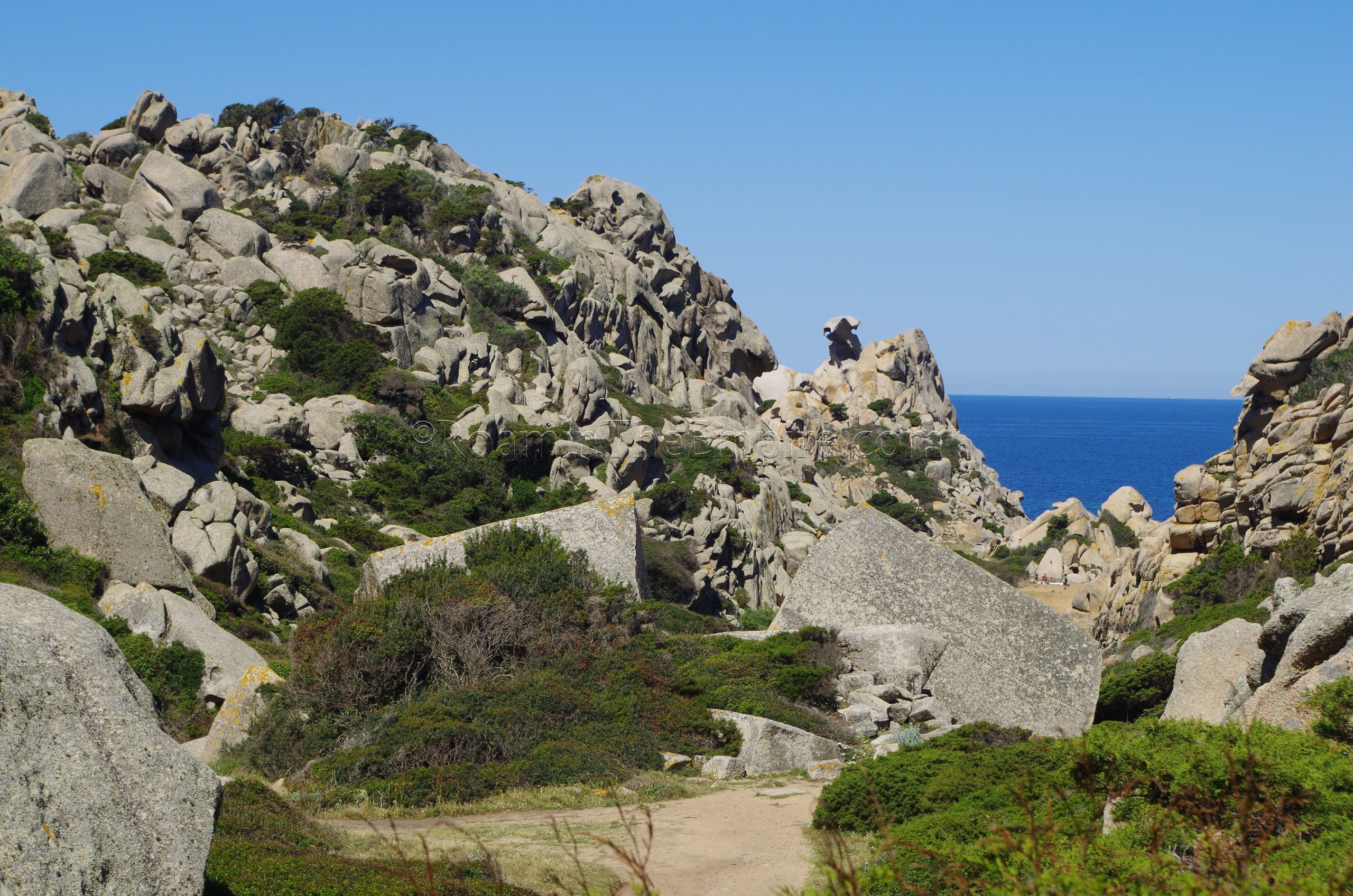
From there, I continued on paths around to the west side of the promontory, which is only about a 10 or 15 minute walk to the next destination, the Valle della Luna. Alternatively, there is also access to the Valle della Luna via a trailhead and some parking on the main road that runs the length of Capo Testa, the Via Cala Spinosa, at the Parcheggio per Valle della Luna. From either direction, one has to descend in and out of the Valle della Luna, though it seemed much more gradual from the south. From the parking area on Via Cala Spinosa, it is not an insignificant hike; and anyone with mobility issues would probably have a pretty tough time. It’s not long, but the last stretch is fairly steep and rocky.
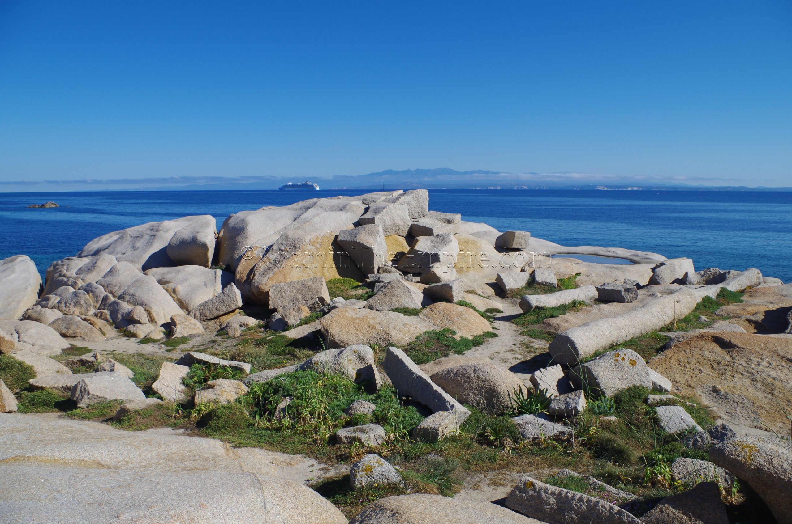
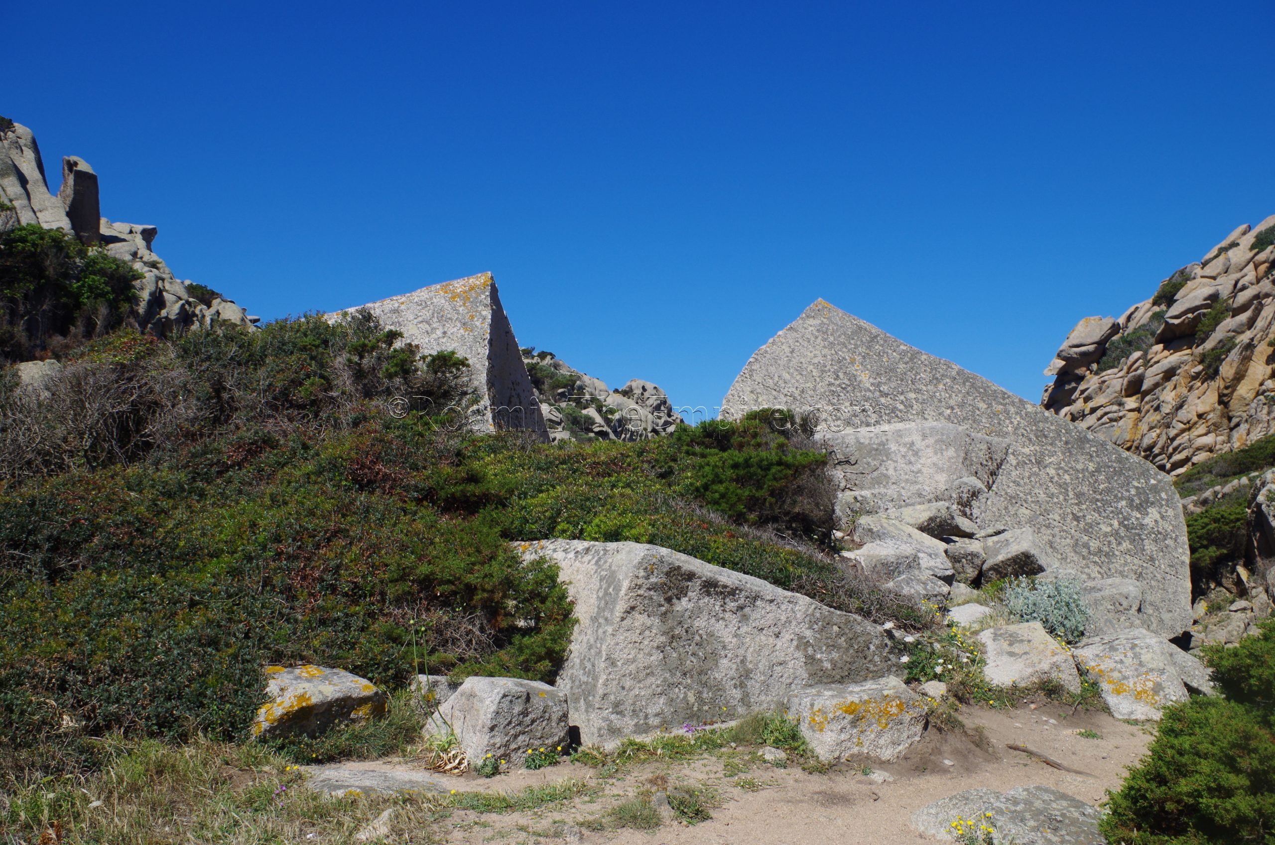
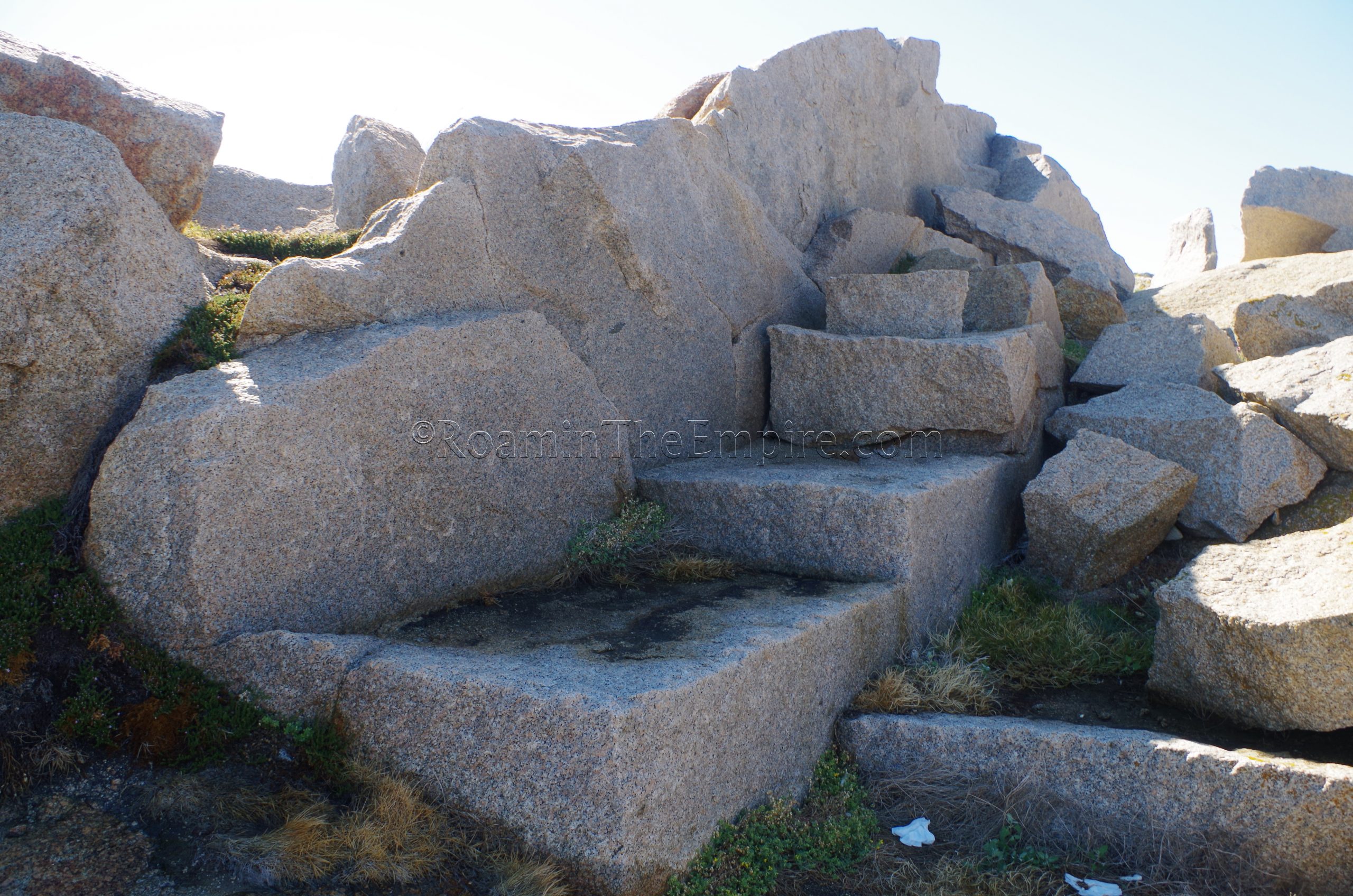
At the foot of Monte La Turri, just past the point where the trail from Via Cala Spinosa reaches the floor of the valley, near the Funtana di La Turri (a small water source) is the Antica Cava Romana, the remains of Roman quarrying activity. Rather than the typical type of quarrying out of the living rock, this area’s activity (or at least what remains of it) seems to mainly center on a very large boulder that was in the process of being broken into useable blocks. While there are quite a few small blocks already quarried off the boulder, it is still pretty significantly sized. The large section has been split in a few parts that are roughly still in-situ where they fell, with the quarrying marks visible along the seams of the break. One of the large sections of the boulder also has the telltale dotted line makings indicating a future cut to be made in breaking down the boulder.
There was one point to the east of the boulder and pile of blocks that looked like there might have been a quarrying point from the living rock. There were also a few large worked boulders a little way up the slope of Monte La Turri that were visible. There didn’t appear to be any obvious signs of quarrying on the face of the mountain that would maybe indicate some point at which these large chunks of rock were initially quarried off. There weren’t any really apparent paths up that side of the mountain, but it would have been interesting to see if there was any activity farther up. There is some question as to whether the quarrying at Valle della Luna is indeed Roman, or whether it dates to a later period, particularly given the location so far inland.

Mureddaggia Quarry
The easiest way to get to the next quarrying area is to hike up the trail toward Via Cala Spinosa. About 200 meters north, down Via Cala Spinosa, is a path down to the Spiaggia di Cala Spinosa. The entrance to the beach is a little misleading, as it is right at the same point of entrance to the adjacent restaurant, the Sea Lounge, and is not very clearly marked. To the right of the boardwalk to the restaurant, though, is a dirt path down to the beach. The path is rather steep and rough, so exercise caution. One must then walk to the far (northeast) end of the beach, at which there is a path leading up into a rocky area. The path continues on along the water’s edge and eventually onto some dirt trails, continuing in a northeastern direction. At the point where the path veers off to the southeast is where the access point to a rocky inlet is located. Approach from the southeast is hampered by private roads and paths that are blocked off or gated at some points, so the approach from the Spiaggia di Cala Spinosa is easiest.
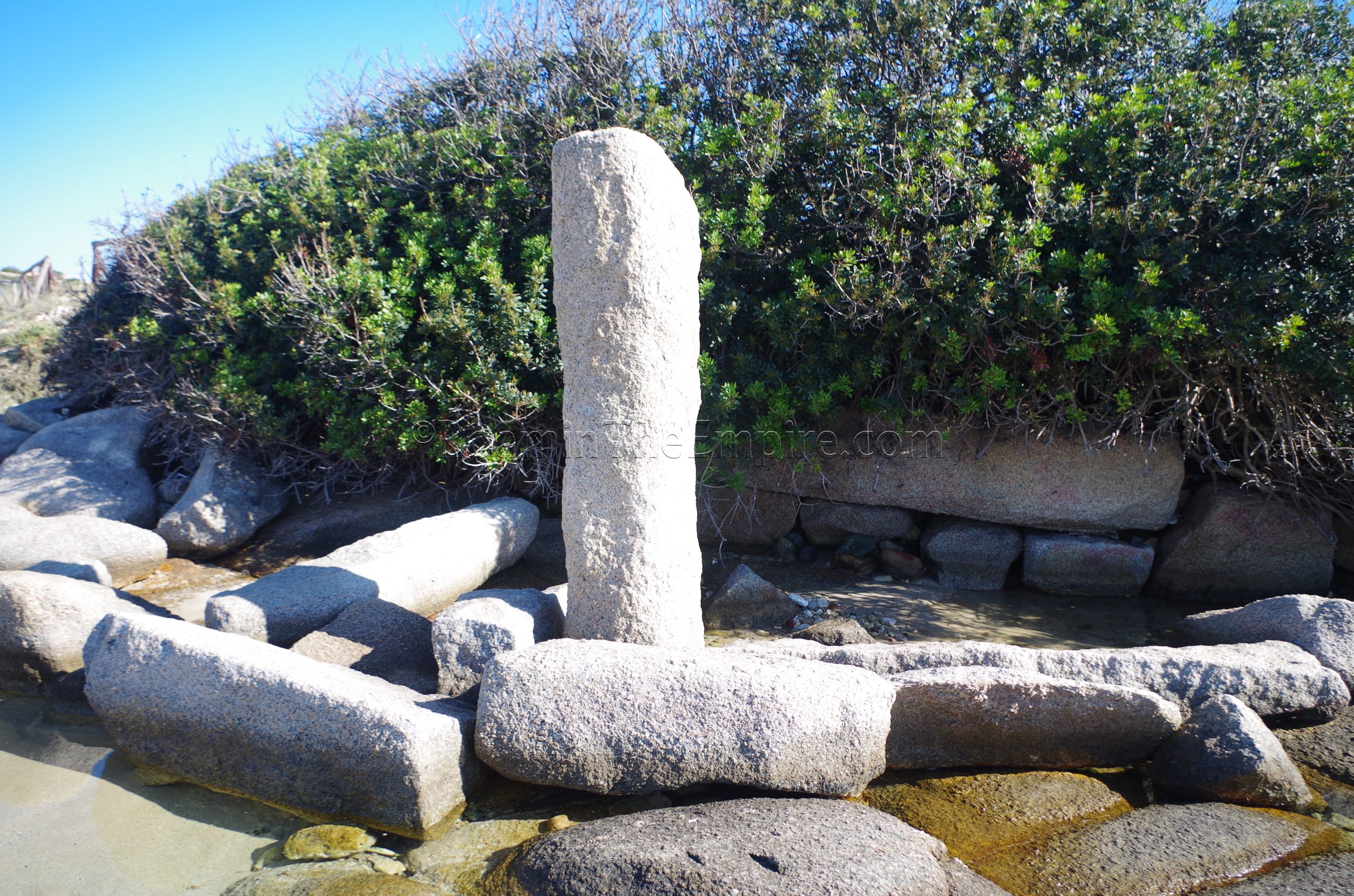
The most apparent evidence of quarrying at Mureddaggia is on the west side of this cove. Orthogonal cuts in the rock as well as tool marks on the granite here are pretty clearly visible at, and just below, the elevation where one enters the cove from the trail. Below the cuts in the living rock, closer to the water level are loose chunks of rock, and among these, rounded pieces of columns. The size of the granite deposits at Capo Testa apparently made them especially good quarries for columns, allowing for the fabrication of large columns out of a single piece of granite.
Capicciolu Quarry
The final archaeological point to visit on Capo Testa is in the northeast part of the promontory, at the Capicciolu Quarry. This is perhaps the easiest of the quarries to visit; there’s no hiking required and there is probably the largest dedicated free parking area (read, not just the sparse shoulder of the road) on the promontory. The easiest access is via the Spiaggia Zia Culumba. The entry off Via Cala Spinosa is on the south end of the beach and the quarrying activity and trail to Punta Acuta starts on the north end of the beach.
The quarrying remains are basically spread out along the coast from the north side of Spiaggia Zia Culumba to the north east point of the land here. At the north end of the beach, a worn and possibly unfinished Roman column has been stood upright on the beach. There are a few segments of columns and cut blocks laying around on the beach as well. It’s difficult to follow the coastline exactly from this point, so it’s easier to head back to where the slightly inland path starts and take that about 100 meters up the coast to the Punta Acuta beach. There are a few remains of blocks and some scattered quarrying points on the left (north) side of trail between the two beaches. On this beach, the remains of a Roman port structure for loading up the quarried granite can be seen.
On the north side of the Punta Acuta beach is where the quarrying activity gets pretty intensive and prolific. There are cuts in the living rock, including step quarrying points. Several columns, including a few of significant size (4 meters or so in height) as well as unfinished blocks are present. Some unfinished stone remnants bear the hash marks of planned, but never made, cuts. The waste material of the quarrying is also abound, with irregularly shaped fragments that bear the marks of quarrying, but clearly weren’t intended to actually be used in anything. The rocky outcropping that makes up the northeastern most point of the promontory has evidence of the quarrying throughout. Ceramic evidence (or rather lack of earlier ceramic evidence) suggests that quarrying began at the Capicciolu Quarry in the early 2nd century CE.
I spent a total of about 3 hours on the Capo Testo promontory and was able to comfortably see everything on foot. I can cover uneven ground and uphill hikes at a pretty decent clip, so the moderate difficulty of access to the first two quarries could certainly add some time for those that are perhaps not as comfortable with those obstacles. If beaches are your thing, it would also make a pretty good day trip in conjunction with that as well. I’ve grown to be really fascinated by Roman quarries, and the presence of the large block at the Valle della Luna quarry and the columns at the Cala Spinosa and Punta Acuta quarries are particularly interesting aspects of the Capo Testo quarries. There’s really no information on-site, and the quarries aren’t even advertised by any kind of signage; you definitely have to know ahead of time they’re there.


Sources:
Bouchier, Edmund Spenser. Sardinia in Ancient Times. Oxford: B. H. Blackwell, 1917.
Careddu, N., and S. Grillo. “Rosa Beta Granite (Sardinian Pink Granite): a Heritage Stone of International Significance from Italy.” Global Heritage Stone: Towards International Recognition of Building and Ornamental Stones, GSL Special Publications, 2015, pp. 155–172.
Ptolomy. Geographica, III.3.
Waelkens, Marc, Norman Herz, and Luc Moens (editors). Ancient Stones: Quarrying, Trade and Provenance. Leuven: Leuven University Press, 1992.
Wilson, Roger J. A.. “Ancient Granite Quarries on the Bocche di Bonifacio.” Classical Marble: Geochemistry, Technology, Trade, Springer Science and Business Media, 1988, pp. 103-112.