


Quick Info:
Address:
C/ Puig i Cadafalch s/n
17130 Empúries-l’Escala
Hours:
Everyday 10:00-17:00/18:00/20:00
Admission: 5 Euro
Continued From Emporiae Part I (The Museum)
The Roman portion of Emporiae lies to the west of the Greek Neapolis, on a ridge overlooking the Greek settlement, at the location of the encampment of Cato during the campaign against the Iberians in 195 BCE. Several times larger than the Neapolis, only a fraction of the Roman city has been excavated.
In 197 BCE, the area of Emporion was incorporated into the newly formed Roman province of Hispania Citerior. Over the course of the 2nd century BCE, the Greek settlement underwent large construction projects while the Roman settlement remained primarily a military encampment, though took on the form of a more permanent fort, the remains of which have been found beneath the forum. A somewhat disorganized settlement also seems to have sprung up around the fort.
The centering of administrative power for Hispania Citerior in Tarraco and the silting of the sheltered harbor by the Clodianus River (Fluvià River) apparently lead to a decline in trade for Emporion, reducing the overall importance of the city, which had once been an important trading hub. A loss of Iberian trading partners following Roman campaigns against the Iberian tribes might also have contributed to this. Around the turn of the 2nd and 1st centuries BCE, the Roman military encampment transitioned to a civil settlement. The fort was demolished and the settlement around it was razed with the foundations being used for the new, planned settlement.

Throughout the 1st century BCE, the Greek and Roman portions of the city developed separately, with the Greek portion remaining largely autonomous. It is this separation that eventually gave rise to the plural Latin name for the site; Emporiae, reflecting the Greek and Roman separation. At some point during the 1st century BCE, possibly as early as time of Caesar, but certainly by the reign of Augustus, the Roman settlement was given municipium. Emporiae doesn’t seem to have featured in the Spanish campaigns of the Roman civil wars over the course of the 1st century BCE, at least to the point of mention in the sources, but was a location for the settlement of veterans at that time.
In the waning years of the 1st century BCE, the citizens of the Greek town were given citizenship in the municipium of the Roman city and the two settlements were united both administratively and physically, with the walls between the Greek and Roman portions being torn down. Following the Cantabrian Wars from 29-19 BCE, the whole of the Iberian Peninsula was brought under Roman control, and the administration of Hispania was reorganized with Emporiae being incorporated into Hispania Tarraconensis. Among the patrons of the city during this time were Augustus himself, one of his grandsons, and several senators and governors of Hispania.

Following the reign of Augustus, the life of Emporiae seems to be largely unremarkable. The Greek Neapolis appears to have declined somewhat, becoming more of a secondary, industrial area associated with port functions. For instance, in the 1st century CE, a fish salting factory was built in a central location of the Neapolis. By the middle of the 3rd century CE, the entirety of the Roman and Greek portions of the city seem to have been largely abandoned, and the population appears to have shifted to the area of Sant Martí d’Empúries, the location of the original Greek Palaiapolis.
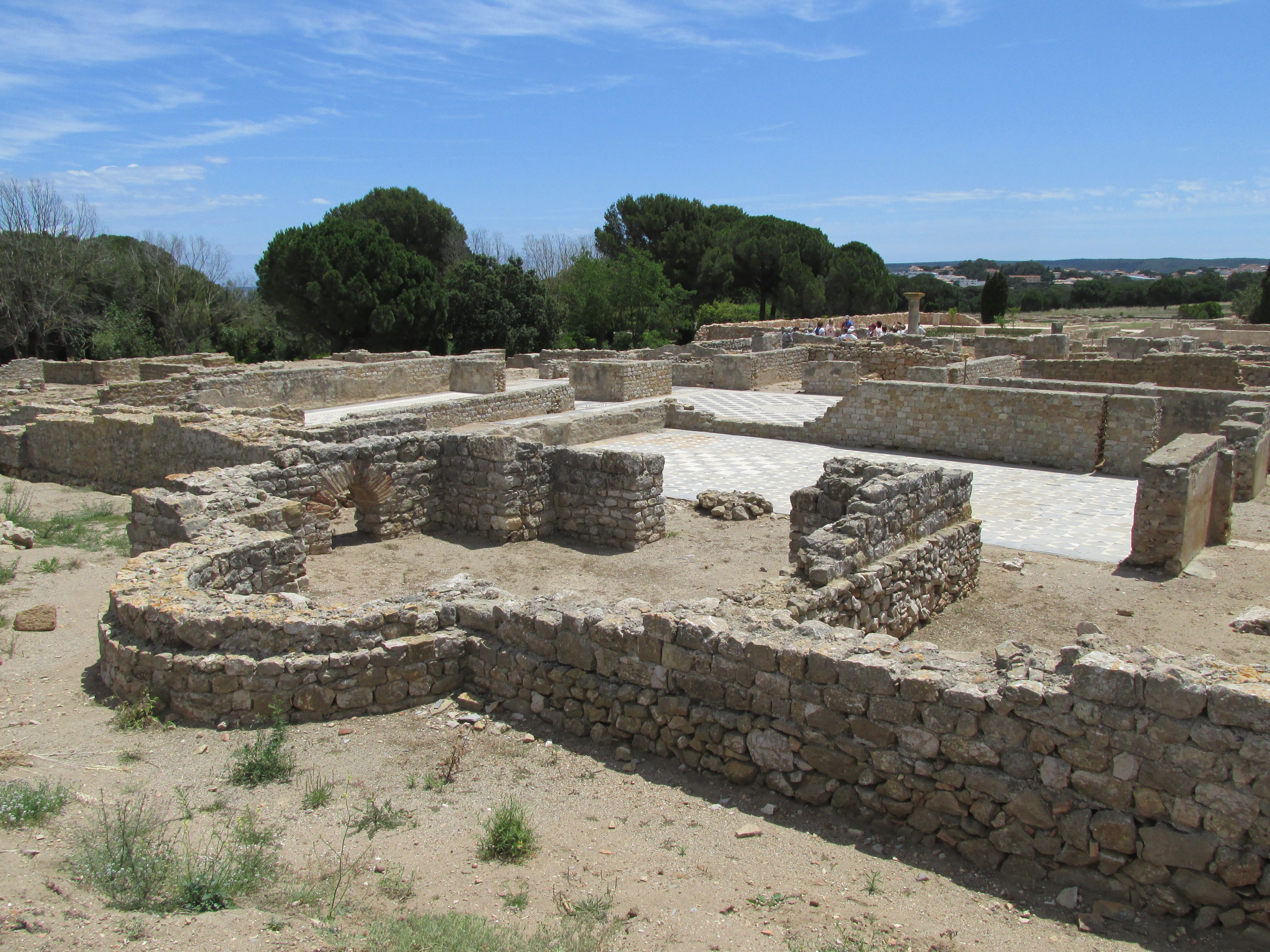
Unlike the Greek Neapolis, only a small portion of the Roman settlement is excavated; no more than 25%. The largest excavated portion of the settlement is a series of three large domūs in the northeast section of the Roman settlement (as it pertains to the remains in the archaeological park, at least; the Roman settlement extended at least another 350 meters NNW from that area).

The northernmost and largest of the three is Domus 1, of which the earliest building phase can be traced to the 1st century BCE with successive building phases extending into the 1st century CE. The size and location of the domus would seem to indicate that the unknown family owning it likely had high standing in the social structure of Emporiae.

In addition to the frequently used atrium style core of the dwelling (the oldest portion of the domus), Domus 1 also features a large peristyle to the south of the atrium, and a large garden area in the rear of the property. Several of the rooms, particularly in the northern portion of Domus 1, have in situ mosaics present, though that area of the property is largely closed off, and many of the mosaics can only be viewed from a distance, or from the higher ground overlooking the domus from the north.

To the south of Domus 1 are Domus 2a and Domus 2b. The former is a relatively small atrium style dwelling that occupies a space of roughly 25×25 meters in the northwest corner of an area that is otherwise occupied by the larger Domus 2b. Though smaller than Domus 1, Domus 2b also includes a peristyle and gardens in addition to its atrium area, as well as at least 3 triclinia and a very small bath area. Like Domus 1, both Domus 2a and 2b were originally constructed in the 1st century BC with later additions and improvements dating into the 1st century AD.

Caldarium of the public bathing complex.
Across Cardo A, to the west of the Domus 2a and Domus 2b complex, is Insula 30, which contains a public bathing complex dating to the 1st-2nd century CE in the north of the block, with tabernae occupying the southern portion of the block. The city baths consist of the typical ameneties expected at a Roman bathing complex. The water supply for the complex, however, seems to have been fed by a 27 meter deep well with a wheeled mechanical system used to draw the water up for the baths.Recent excavations in the southern portion of Insula 30 have revealed the presence of a Republican-era house below the tabernae.

Adjacent to Insula 30, toward the southwest, is the forum area. The forum was originally the location of the military camp prior to the founding of the Roman settlement. Most of the buildings in the forum have origins in the 1st century BCE, but the entire forum area was renovated during the Augustan area. A porticoed ambulacrum rings the forum square along the east, south, and west edges; with a reconstructed section in the southwest corner.

The basilica is also located on the east side of the forum square. In the southeastern corner is the curia, the basement of which has been preserved and is (mostly) visible through some scuffed and dirty windows in the floor level. A series of exterior facing tabernae are situated around the forum on the south and west sides.

The northern edge of the forum is dominated by a religious precinct in which a series of shrines and temples, including one dedicated to Augustus, and the Capitolium are located. Ringing this religious precinct is a double portico and cryptoporticus.

An entrance in the south of the forum area leads onto a section of the cardo maximus that stretches for about 165 meters leading to the south gate of the settlement. A short distance outside of the forum, the cardo maximus is lined on either side by a series of small tabernae stalls. To the east of the cardo maximus, adjacent to the southeast corner of the forum, is another insula containing small residential dwelling and commercial enterprises.

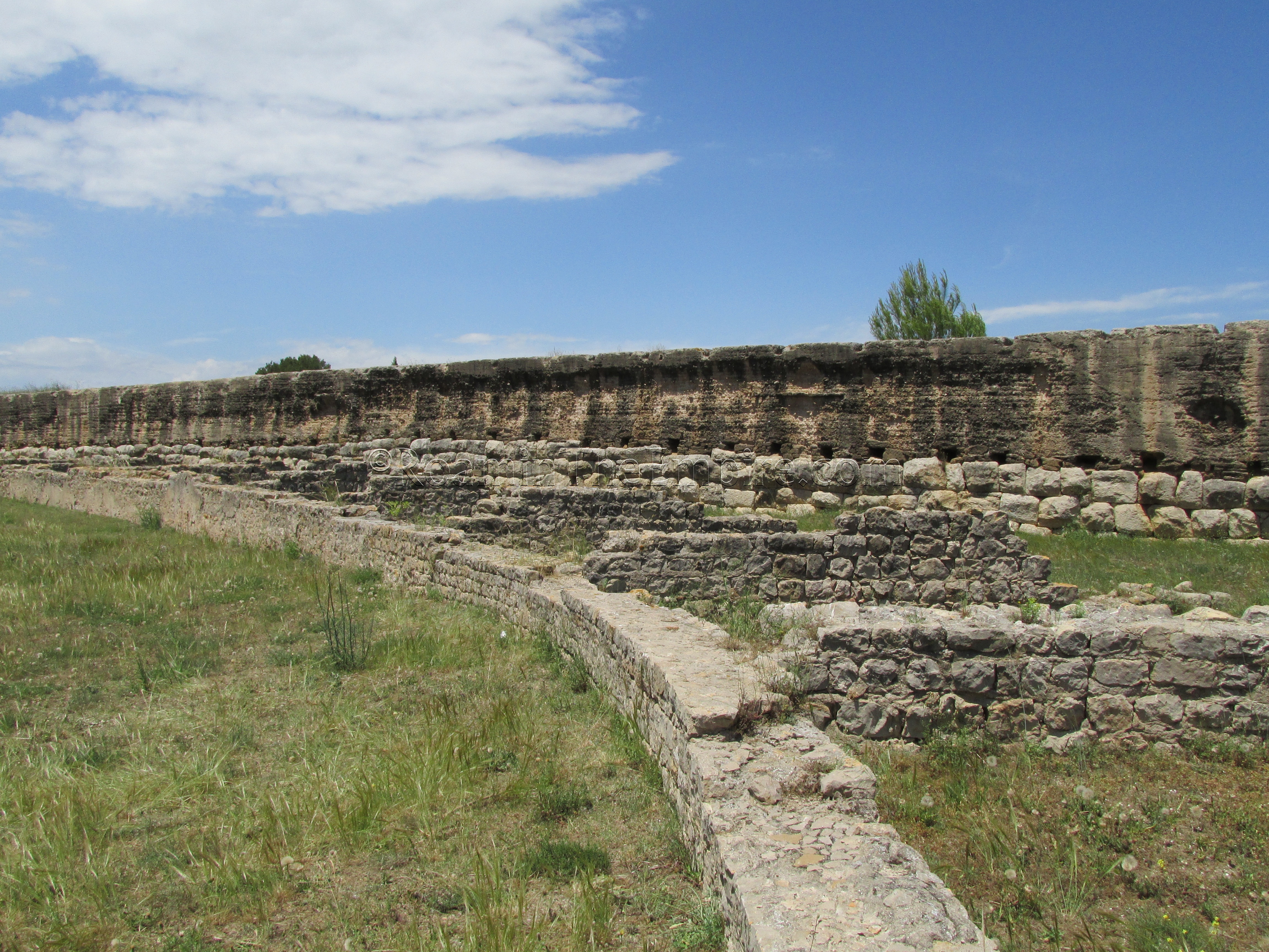
Much of the southern wall of the settlement, dating to the 1st century BCE, is intact. The east-west dimension of the city walls were about 300 meters, while the north-south walls ran for about 700 meters. No paving stones remain on the cardo maximus, but the stones of the threshold of the southern gate bear the wear marks of cart wheels. The wall is constructed of a base of calcareous ashlar stones with opus caementicium on top. On the exterior of the southern gate, on the east side of the entrance, a phallic symbol is carved into one of the ashlars of the wall facing.
Exiting the southern gate, the amphitheater is located to the west. The amphitheater was constructed in the 1st century AD of stone walls and supports, some of which remain, with wood seating. The amphitheater could hold about 3,300 people.

To the east of Emporiae’s amphitheater is the palaestra, which measured about 111 x 68 meters and was surrounded by a porticoed gallery. Like the amphitheater, the palaestra was built in the 1st century AD.
Continued In Emporiae Part III (The Greek Settlement)
Sources:


Carr, Raymond. Spain: A History. New York: Oxford UP, 2000.
Cottrell, Leonard. Hannibal: Enemy of Rome. Boston: Da Capo Press, 1991.
Curchin, Leonard A. Roman Spain: Conquest and Assimilation. New York: Routledge, 1991.
Empúries Archaeological Site materials and placards.
Kaiser, Alan. “Ethnic Identity and Urban Fabric: The Case of the Greeks at Empúries, Spain.” Journal of Mediterranean Archaeology 13.2 (2001): 189-203.
Livy, The History of Rome, 34.8-10.
Mierse, William E. Temples and Towns in Roman Iberia: The Social and Architectural Dynamics of Sanctuary Designs from the Third Century B.C. to the Third Century A.D. Berkeley, CA: U of California, 1999.
Polybius, Histories, 3.76.
Strabo, Geography, 3.4.8.